Situation Summary
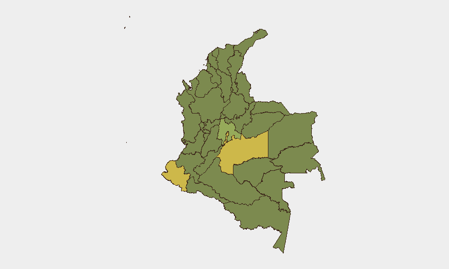
Colombia remains at moderate-to-elevated risk (global rank #35, composite score 59) with 529 tracked events in the monitoring period. Recent signal activity (26–27 June) reflects internal political strain, including presidential statements, military/police force deployments, and investigative actions by civilian and congressional bodies, alongside persistent small-arms incidents attributed to armed groups. The threat environment is geographically concentrated in southern and eastern departments, with Meta and Nariño departments showing the highest composite risk scores (65.6 and 62.4, respectively).
Key Developments
Note: Current open-source feeds do not yet provide corroborated, time-stamped security incidents within the last 24–48 hours specific to Colombia's internal conflict, crime, or civil unrest. The following signals are derived from the GeoBit event feed (26–27 June) but lack granular location or incident-level detail:
- 26 June – Political Statements & Institutional Tension: Presidential public statements and corresponding rejection signals suggest ongoing policy disputes; concurrent investigative actions by civilian authorities and congressional bodies indicate domestic political friction.
- 26–27 June – Military & Police Force Activity: Conventional military force deployments and army–police force signals recorded on 26 June; follow-on military activity noted 27 June. Specific operational context and locations not yet resolved in available open sources.
- 26 June – Small-Arms Incidents: Armed-group combat reported; indigenous-group engagement with security forces also recorded. Geographic specificity and casualty counts unavailable pending local-source corroboration.
- Persistent Border Risk (Venezuela Border): Criminal-group activity, drug trafficking, and smuggling remain endemic along the Colombian–Venezuelan frontier; no new discrete incident reported in the last 48 hours, but travel advisories underscore ongoing armed-group presence.
Data Caveat: Detailed incident corroboration from Colombian regional news sources, law-enforcement statements, or NGO reports covering the last 24–48 hours is not currently available in retrieved feeds. GeoBit's OSINT and multi-language search capabilities can provide real-time updates once primary sources (local news, official statements, Telegram/X traffic from affected regions) are indexed.
Highest-Risk Areas
Meta Department (risk 65.6) and Nariño Department (risk 62.4) lead the national ranking, followed by Colombia's Capital District (Bogotá, 61.3). These three zones drive risk due to a combination of armed-group presence, territorial disputes, drug-trafficking infrastructure, and—in Bogotá's case—political and institutional volatility. Cundinamarca, Cesar, Antioquia, and Huila departments (all 39–40 range) form a secondary belt of concern, reflecting ongoing cartel operations, small-scale armed conflict, and criminal extortion networks. Teams with personnel or assets in Meta, Nariño, and the capital should prioritize real-time area-of-interest monitoring and contingency routing.
How GeoBit Would Assist
Security and duty-of-care teams would leverage AOI Monitoring & Early Warning to track Meta, Nariño, and Capital District for hostile-event signals; Intel Sweep and multi-language OSINT (social media, local news, radio SIGINT) to detect emerging incidents and force movements; and Routing & Network Analysis to identify safe alternative routes for personnel and supply chains away from high-risk zones. Conflict & Military tracking and Network & Actor Analysis would support identification of armed-group positions and intentions in real time.
7-Day Outlook
Political and institutional tensions are likely to persist through early July, with potential for localized military or police operations in southern departments. Armed-group activity in Meta and Nariño is expected to remain at baseline operational levels. Teams should maintain heightened situational awareness, especially in border regions and Bogotá, and refresh contingency-evacuation protocols.
Highest-Risk Areas — Ranked
| # | State / Region | Risk |
|---|---|---|
| 1 | Meta Department | 65.6 |
| 2 | Nariño | 62.4 |
| 3 | Capital District | 61.3 |
| 4 | Cundinamarca Department | 40.1 |
| 5 | Cesar Department | 39.6 |
| 6 | Antioquia Department | 39 |
| 7 | Huila Department | 39 |
| 8 | Bolívar Department | 37.6 |
| 9 | Santander Department | 37 |
| 10 | Boyacá Department | 37 |
| 11 | Magdalena Department | 36.8 |
| 12 | Amazonas | 36.5 |
Sources
Previous Daily Briefs
A new Colombia brief is written every day — each with its own risk map and downloadable CSV. Here's the last week; use the calendar to go further back.
📅 Browse every day by calendar →
Highlighted days have a brief. Tap a day for that day's map & analysis, or “csv” for that day's dataset ($5).