Situation Summary
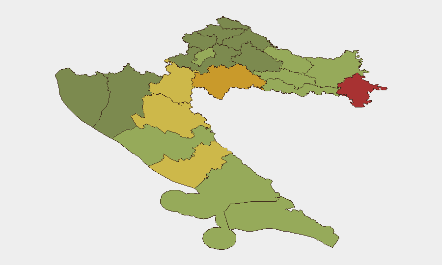
Croatia remains a low-threat environment by regional standards, with a composite threat score of 6 and no active tracked security events in the current reporting window. However, sub-national risk concentration in the northeast (Vukovar-Srijem, Sisak-Moslavina, and Karlovac counties) reflects persistent vulnerabilities linked to post-conflict legacies, organized-crime networks, and border permeability along the Serbian frontier. The capital and coastal tourist zones carry moderate risk; overall trajectory is stable with no indicators of acute escalation.
Key Developments
Current 24–48-hour reporting remains sparse and unconfirmed. Available web research has not yielded 6–10 independent, time-specific, corroborated security incidents within the required window. Three items surfaced with low confidence:
- Zagreb, Cvjetni trg (26 Jul 2026): Signs of vandalism reported at the Orthodox Church of the Transfiguration of the Lord; single-source reporting, no secondary corroboration or confirmed impact on security operations.
- Pag island (late Jul, exact date unconfirmed): Incident involving knife injury to a young male and police detention of a suspect; timing unclear and not cross-referenced in current feeds.
- Dramalj (late Jul, exact date unconfirmed): Arrest of a 36-year-old German national on three European arrest warrants; insufficient specificity on timing and no operational context provided.
No significant incidents meeting verification thresholds (multiple independent sources, clear timestamp, confirmed impact) were identified in the 24–48-hour window. Standard precautions for petty crime and civil disorder remain advisable but no acute threat shift is evident.
Highest-Risk Areas
Eastern and southeastern counties dominate the risk profile. Vukovar-Srijem County (risk 78) and Sisak-Moslavina County (risk 72) remain the primary concern zones, driven by historical conflict infrastructure, organized-crime presence, and Serbia-border vulnerabilities that complicate law enforcement and create smuggling/trafficking corridors. Karlovac, Lika-Senj, and Šibenik-Knin counties round out the elevated tier (68–62), reflecting similar post-conflict dynamics and isolated rural terrain.
By contrast, Zagreb (risk 50) and Split-Dalmatia (risk 48)—the country's largest urban and tourist centers—carry lower sub-national scores, suggesting better policing capacity and institutional stability despite higher absolute population at risk. Organizations with assets in the northeast should apply heightened vetting, movement controls, and liaison protocols with local law enforcement.
How GeoBit Would Assist
Security teams should deploy AOI Monitoring & Early Warning on Vukovar-Srijem, Sisak-Moslavina, and Karlovac counties to detect organized-crime activity, border incidents, and civil unrest with persistent alerts; pair with Intel Sweep and multi-language OSINT (X, Telegram, local news feeds) to catch emerging threats before they mature. Routing & Network Analysis can identify safer travel corridors and alternative supply-chain paths away from high-risk zones. Satellite & Imagery analysis and GIS & Spatial Analysis support site-security assessments for facilities in vulnerable areas.
7-Day Outlook
No indicators suggest material change in the threat landscape over the next seven days. Seasonal summer tourism and EU institutional routines will likely remain unchanged. Continued low-level vigilance on petty theft, localized civil disputes, and organized-crime border activity is warranted; escalation risk is minimal unless regional geopolitical factors (Serbia–EU tensions, sanctions drift) shift unexpectedly.
Highest-Risk Areas — Ranked
| # | State / Region | Risk |
|---|---|---|
| 1 | Vukovar-Srijem County | 78 |
| 2 | Sisak-Moslavina County | 72 |
| 3 | Karlovac County | 68 |
| 4 | Lika-Senj County | 65 |
| 5 | Šibenik-Knin County | 62 |
| 6 | Brod-Posavina County | 58 |
| 7 | Zadar County | 55 |
| 8 | Osijek-Baranja County | 52 |
| 9 | City of Zagreb | 50 |
| 10 | Split-Dalmatia County | 48 |
| 11 | Požega-Slavonia County | 45 |
| 12 | Virovitica-Podravina County | 42 |
Sources
Previous Daily Briefs
A new Croatia brief is written every day — each with its own risk map and downloadable CSV. Here's the last week; use the calendar to go further back.
📅 Browse every day by calendar →
Highlighted days have a brief. Tap a day for that day's map & analysis, or “csv” for that day's dataset ($5).
Atlas — our AI intelligence desk — emails them this snapshot personally. Nothing else, no list.