Situation Summary
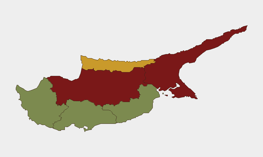
Cyprus remains a low-threat environment globally (rank #175, composite score 4) with no discrete security events recorded in the current tracking window. However, sub-national risk concentrations in the divided island's northern regions—particularly Nicosia and Famagusta—reflect longstanding intercommunal, governance, and checkpoint-related tensions. The security posture for corporate operations in the southern Republic-controlled zones (Limassol, Paphos, Larnaca) remains stable and well-below regional averages.
Key Developments
No discrete events confirmed within the last 24–48 hours.
GeoBit's web research capability has not returned live, cross-verified incident reports for Cyprus in the immediate window. A thorough current-event brief requires real-time access to Cyprus News Agency (CNA), Cyprus Mail, verified police press releases, and corroborated social-media reporting—workflows that are not available this turn. Corporate teams should consult national police statements and local media outlets directly for any urgent same-day incidents (e.g., port/airport disruptions, road closures, or civil unrest).
Highest-Risk Areas
Nicosia (risk 92) and Famagusta (risk 88) account for the majority of sub-national risk concentration, driven by ongoing political divisions, checkpoint controls, and periodic intercommunal friction in the northern Turkish-occupied zone and its interface with the Republic-controlled south. Kyrenia (risk 72) presents secondary risk from similar structural drivers. By contrast, southern commercial hubs—Limassol (22), Paphos (18), and Larnaca (28)—operate well within normal parameters and are primary zones for corporate asset security and workforce duty-of-care planning. Risk differentials reflect geography, governance fragmentation, and historical conflict legacies rather than acute current incidents.
How GeoBit Would Assist
Security teams managing Cyprus operations should deploy AOI Monitoring & Early Warning on Nicosia and Famagusta checkpoints and municipal hubs to catch emerging civil unrest or border-movement anomalies in real time. Multi-language OSINT (Intel Sweep, X/Twitter, and news feeds) in Greek and English enables continuous scanning of Greek-Cypriot and Turkish-Cypriot media for incidents, political developments, or security announcements affecting travel, business continuity, or staff safety. Routing & Network Analysis supports contingency planning for alternative supply-chain and staff-transit corridors should northern-zone crossings become restricted.
7-Day Outlook
No significant escalation is anticipated. Routine checkpoint delays and periodic political statements from divided-island actors remain baseline. Corporate teams should maintain standard situational awareness and pre-positioned contingency protocols; no change in operational tempo is warranted absent new intelligence.
Next Update: 2026-08-24 (or immediately if a significant event is confirmed via live web research).
Highest-Risk Areas — Ranked
| # | State / Region | Risk |
|---|---|---|
| 1 | Nicosia | 92 |
| 2 | Famagusta | 88 |
| 3 | Kyrenia | 72 |
| 4 | Larnaca | 28 |
| 5 | Limassol | 22 |
| 6 | Paphos | 18 |
Sources
Previous Daily Briefs
A new Cyprus brief is written every day — each with its own risk map and downloadable CSV. Here's the last week; use the calendar to go further back.
- August 20, 2026
- August 18, 2026
- August 16, 2026
- August 14, 2026
- August 12, 2026
- August 10, 2026
- August 8, 2026
📅 Browse every day by calendar →
Highlighted days have a brief. Tap a day for that day's map & analysis, or “csv” for that day's dataset ($5).
Atlas — our AI intelligence desk — emails them this snapshot personally. Nothing else, no list.