Situation Summary
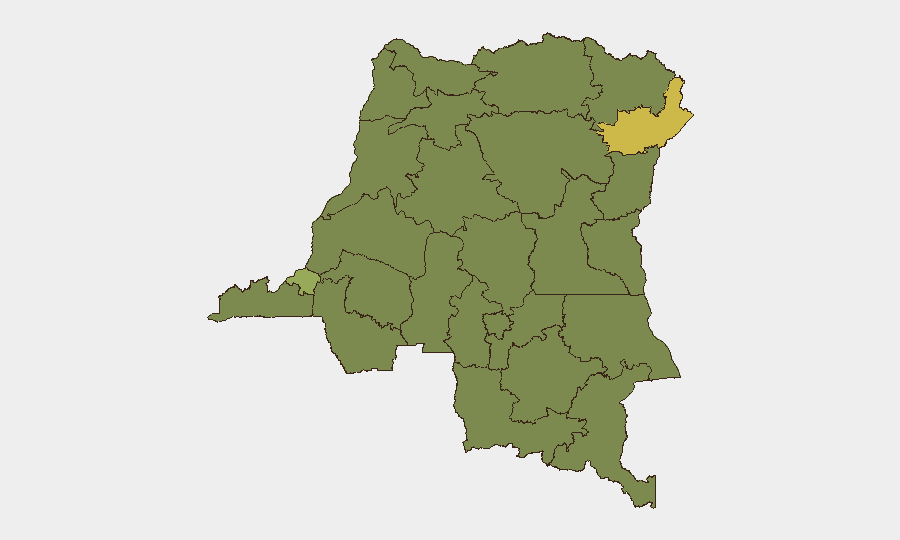
DR Congo remains at significant risk (composite threat score 64, #21 globally) driven primarily by ongoing civil conflict and armed-group activity concentrated in the eastern provinces. The security environment is characterised by persistent banditry, displacement, and cross-border spillover, with Ituri Province representing the most acute flashpoint. While Kinshasa maintains relative stability, the broader eastern conflict zone—particularly North Kivu, Maniema, and the Upper Uele corridor—continues to generate high personnel and asset risk for organisations operating outside the capital.
Key Developments
- Ituri Province (Bunia/Mambasa), 18–19 June — WHO reporting documented a sharp rise in confirmed Ebola cases, triggering movement restrictions and intensified screening on major roads. Cross-border health controls have been activated, directly disrupting supply chains and personnel travel.
- Kasindi/Mpondwe border (DRC–Uganda), 20–21 June — Ugandan authorities suspended DRC flight operations and tightened border patrols in response to the Ebola spike, creating bottlenecks for expatriate evacuation and logistical movements.
- Walikale and Masisi territories, North Kivu, 20–21 June — UN reporting confirmed renewed fighting with mass civilian displacement (hundreds of families); secondary roads in the territory remain compromised and humanitarian access degraded.
- Ingbokolo area, Ituri/South Sudan border, 18 June — South Sudan's Central Equatoria authorities reinforced Ebola screening following a suspected case near the DRC frontier, indicating transnational public-health spillover risk.
- Eastern DRC (regional), 18–19 June — Security analysis indicates persistent armed-group activity and banditry across the conflict zone; no major new clashes independently verified in the 48-hour window, but threat posture remains unchanged.
- Kinshasa (national), 18–19 June — Urban security conditions remain stable with no signs of mass civil unrest or fresh capital-wide instability. Civil-order risk in the capital remains below the provincial average.
Highest-Risk Areas
Ituri Province (62.8) and Kinshasa (42.8) drive the majority of DR Congo's threat score. Ituri's ranking reflects the convergence of armed-group activity, the current Ebola outbreak, and the density of humanitarian and commercial operations dependent on unreliable transport corridors. Kinshasa's elevated score, despite greater absolute stability than eastern provinces, reflects its concentration of critical infrastructure, expat populations, and vulnerability to national-level political shocks. The second tier—Maniema, Nord-Ubangi, Équateur, and North Kivu (all 32.8)—represents a persistent mid-to-high risk band characterised by cross-border spillover, limited state capacity, and armed-group recruitment activity. Organisations with presence in Ituri or the eastern corridor face the highest duty-of-care exposure.
How GeoBit Would Assist
Security teams should deploy Intel Sweep and multi-language OSINT feeds to track real-time armed-group movements and health-system status in Ituri and North Kivu, AOI Monitoring & Early Warning on the Kasindi and Mpondwe border crossings to anticipate movement disruptions, and Routing & Network Analysis to identify alternative supply and evacuation pathways as primary corridors degrade. Satellite & Imagery analysis of displacement camps and Conflict & Military battle mapping enable validation of UN displacement claims and forward positioning of armed actors.
7-Day Outlook
The Ebola outbreak is likely to persist as a primary mobility constraint in Ituri and along the Uganda border for at least the next 7–10 days, independent of armed conflict. North Kivu fighting may generate secondary displacement waves into Maniema. No immediate nationwide political shock is forecast, but eastern provinces should be treated as operationally constrained through late June.
Highest-Risk Areas — Ranked
| # | State / Region | Risk |
|---|---|---|
| 1 | Ituri | 62.8 |
| 2 | Kinshasa | 42.8 |
| 3 | Maniema | 32.8 |
| 4 | Sud-Ubangi | 32.8 |
| 5 | Équateur | 32.8 |
| 6 | Nord-Ubangi | 32.8 |
| 7 | Mongala | 32.8 |
| 8 | Lower Uele | 32.8 |
| 9 | Tshopo | 32.8 |
| 10 | Tshuapa | 32.8 |
| 11 | Upper Uele | 32.8 |
| 12 | North Kivu | 32.8 |
Sources
Previous Daily Briefs
A new DR Congo brief is written every day — each with its own risk map and downloadable CSV. Here's the last week; use the calendar to go further back.
📅 Browse every day by calendar →
Highlighted days have a brief. Tap a day for that day's map & analysis, or “csv” for that day's dataset ($5).