Situation Summary
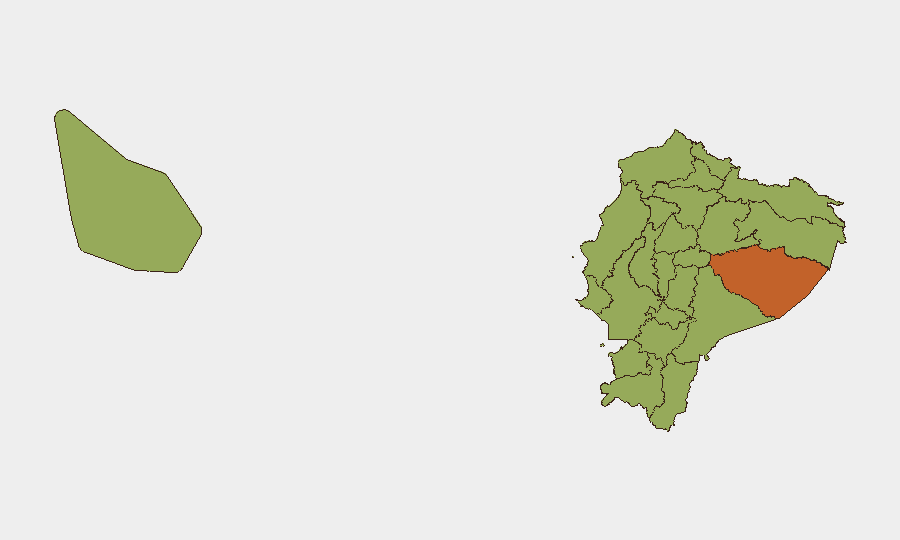
Ecuador faces escalating criminal violence concentrated in coastal and northern provinces, driven by micro-trafficking territorial disputes, extortion networks, and inter-gang retaliation. The 56 tracked events and composite threat score of 64 reflect sustained insurgency-related activity, with Pastaza Province and Guayas Province presenting the highest sub-national risks. The last 48 hours show a pattern of gang-driven shootings, extortion operations, and cargo theft across multiple regions, indicating no near-term de-escalation.
Key Developments
- Guayaquil, Guayas Province – 28 June, evening: Armed gunmen in a vehicle conducted a drive-by shooting in Los Esteros sector, killing two and wounding three in a gang-related attack linked to micro-trafficking territorial disputes.
- Durán, Guayas Province – 28 June, night: Motorcycle gunmen carried out a drive-by shooting outside a commercial establishment in El Recreo sector, injuring four; authorities characterize the attack as likely inter-gang retaliation.
- Esmeraldas city, Esmeraldas Province – 28 June, late night: A curfew-time shooting in Las Palmas neighborhood killed one and wounded two; assailants appear linked to drug-trafficking gang clashes in the port area.
- Machala, El Oro Province – 28 June, afternoon: Police dismantled a kidnapping and extortion ring, freeing one hostage, arresting five suspects, and seizing two vehicles and multiple firearms in a coordinated operation.
- Quito, Pichincha Province – 29 June, early morning: Combined police and military operation against an alleged extortion cell resulted in six arrests and seizure of weapons and motorcycles used in "vaccuna" (extortion) operations against local businesses.
- Manta, Manabí Province – 28 June, night: Armed robbers hijacked a cargo truck near port access roads, causing temporary road blockage; cargo losses significant and freight-theft risk elevated on port routes.
- Ambato, Tungurahua Province – 28 June, daytime: False bomb threat against provincial court complex prompted evacuation and security cordon; heightened judicial security maintained.
- Cuenca, Azuay Province – 28 June, evening: Municipal authorities increased police patrols and checkpoints in historic center following multiple armed robberies of tourists and diners.
Highest-Risk Areas
Pastaza Province (risk 75.1) and Guayas Province (risk 57.9) drive Ecuador's threat profile, with Guayas—containing Guayaquil, Durán, and Manta—showing the highest operational incident density in the last 48 hours. Northern provinces including Esmeraldas, Carchi, and Sucumbíos remain elevated due to trafficking corridor positioning and gang presence. Coastal and port-adjacent regions (Manabí, El Oro) face concentrated freight-theft and cartel activity. The ranking reflects both violence frequency and geographic proximity to trafficking networks and territorial gang strongholds.
How GeoBit Would Assist
Security teams should employ AOI Monitoring & Early Warning on Guayaquil, Durán, Manta, and Esmeraldas to detect clustering of extortion and shooting incidents in near-real time. Intel Sweep and OSINT fusion across Telegram, X, and local news feeds will track cartel communication, territorial claims, and retaliation signaling. Routing & Network Analysis supports alternative journey planning for personnel and cargo movements around Los Esteros, El Recreo, and port-approach roads during elevated-risk windows.
7-Day Outlook
Gang violence and extortion operations will likely persist at current intensity through early July, with retaliation cycles continuing in Guayaquil and coastal ports. Cargo theft and roadway robbery remain elevated risks on routes to Manta and Durán. Judicial and government security posture will remain heightened following the bomb threat in Ambato, but no state-level escalation is evident.
Highest-Risk Areas — Ranked
| # | State / Region | Risk |
|---|---|---|
| 1 | Pastaza Province | 75.1 |
| 2 | Guayas Province | 57.9 |
| 3 | Napo Province | 46.3 |
| 4 | Santa Elena Province | 45.7 |
| 5 | Tungurahua Province | 45.7 |
| 6 | Sucumbíos Province | 45.1 |
| 7 | Orellana Province | 45.1 |
| 8 | Manabí Province | 45.1 |
| 9 | Galápagos | 45.1 |
| 10 | Esmeraldas Province | 45.1 |
| 11 | Carchi Province | 45.1 |
| 12 | Imbabura Province | 45.1 |
Sources
Previous Daily Briefs
A new Ecuador brief is written every day — each with its own risk map and downloadable CSV. Here's the last week; use the calendar to go further back.
📅 Browse every day by calendar →
Highlighted days have a brief. Tap a day for that day's map & analysis, or “csv” for that day's dataset ($5).