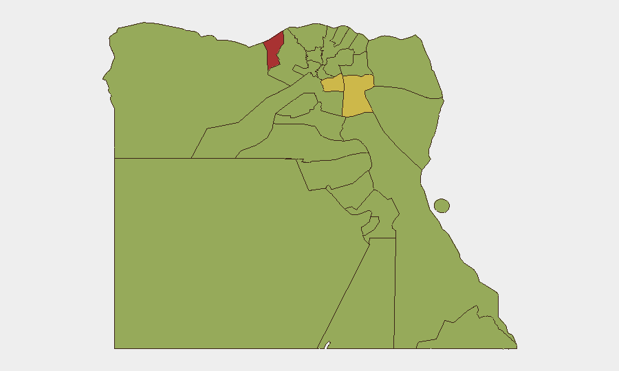
Situation Summary
Egypt's internal security environment remains generally stable with no confirmed major incidents in the last 24–48 hours, but the country faces sustained terrorism risk and heightened border tensions driven by regional conflict spillover. The overall threat score of 67 (rank #24 globally) reflects vulnerability to terror attacks and instability in frontier regions rather than active civil unrest or widespread violence. Egyptian authorities have reinforced military postures along the Gaza and Sinai borders while maintaining diplomatic de-escalation efforts, signaling management of immediate threats but acknowledgment of underlying risk.
Key Developments
- Rafah border (Egypt–Gaza), 25–26 July 2026 – Egypt deployed additional military reinforcements and formally rejected Israel's proposal for an "experimental humanitarian zone" in Tel Al‑Sultan, citing risk of mass displaced Palestinians crossing into Egyptian territory and destabilizing the frontier.
- Red Sea maritime security, recent days – Egypt's Foreign Ministry condemned attacks on civilian shipping and Saudi oil infrastructure, reaffirming solidarity with Saudi Arabia and emphasizing protection of navigation in international waterways.
- Iranian regional escalation, recent days – Egypt strongly condemned renewed Iranian attacks on Kuwait and Bahrain, publicly characterizing them as dangerous violations of sovereignty that heighten regional instability.
- Travel restrictions confirmed, late July 2026 – German and Australian travel advisories reiterate existing bans on civilian travel to northern Sinai, the Egyptian–Israeli border (except Taba), and remote Sahara border zones with Libya and Sudan, all declared restricted military areas by Egyptian authorities.
- US–Iran diplomatic initiative, recent days – Egypt and Qatar jointly called for resumption of US–Iran negotiations and regional de-escalation, signaling active Egyptian diplomatic engagement to reduce conflict spillover risk.
Highest-Risk Areas
Alexandria (77.2) and Cairo (69.2) dominate the sub-national ranking, reflecting density of population, economic infrastructure, and urban exposure to potential terror attacks. The Suez region (64.8) ranks third due to maritime and transit chokepoint vulnerabilities and proximity to Sinai conflict zones. Frontier regions—North Sinai, South Sinai, and the Halaib Triangle—carry elevated scores (47–48 range) driven by insurgent activity, Egyptian military operations, and access restrictions; however, risk in these areas is well-documented and travel is formally prohibited, limiting surprise exposure for corporate personnel. Ad Dakahliya's elevated score (55.1) merits monitoring but reflects lower absolute threat density than the top three regions.
How GeoBit Would Assist
Corporate security teams should deploy Area-of-Interest (AOI) monitoring on Alexandria, Cairo, and the Suez corridor to receive persistent alerts on protest activity, security force deployments, or incident signals in real time. Intel Sweep and multi-language OSINT fusion across Egyptian media, official statements, and social platforms (X/Telegram) provide early warning of terror plots, border escalations, or regime-stability shifts before they affect operations. Routing & network analysis tools allow security teams to plan alternative travel routes and identify chokepoints during regional crises, and maritime tracking informs supply-chain and Red Sea transit planning in response to evolving shipping threats.
7-Day Outlook
No major security escalation is forecast within the next seven days, but the confluence of Gaza border tension, regional Iran–US dynamics, and sustained terrorism risk means Egypt remains exposed to sudden incidents or travel disruptions. Monitoring of Rafah deployments and statements from Egyptian military and foreign ministry will be key indicators of border stability. Corporate teams should maintain heightened awareness and contingency protocols for rapid evacuation or rerouting should regional hostilities or domestic terror incidents occur.
Highest-Risk Areas — Ranked
| # | State / Region | Risk |
|---|---|---|
| 1 | Alexandria | 77.2 |
| 2 | Cairo | 69.2 |
| 3 | Suez | 64.8 |
| 4 | Ad Dakahliya | 55.1 |
| 5 | South Sinai | 48.1 |
| 6 | Giza | 48.1 |
| 7 | North Sinai | 47.2 |
| 8 | Qena | 47.2 |
| 9 | Red Sea | 47.2 |
| 10 | Halaib Triangle | 47.2 |
| 11 | Matruh | 47.2 |
| 12 | Kafr El Sheikh | 47.2 |
Sources
Previous Daily Briefs
A new Egypt brief is written every day — each with its own risk map and downloadable CSV. Here's the last week; use the calendar to go further back.
📅 Browse every day by calendar →
Highlighted days have a brief. Tap a day for that day's map & analysis, or “csv” for that day's dataset ($5).
Atlas — our AI intelligence desk — emails them this snapshot personally. Nothing else, no list.