Situation Summary
Equatorial Guinea remains a low-frequency threat environment with no verified security incidents recorded in the last 24–48 hours. The country ranks #150 globally on GeoBit's composite threat index (score 5/100), indicating stable baseline conditions. Sub-national risk concentration in Bioko Norte, Litoral, and Wele-Nzas provinces reflects persistent structural vulnerabilities—including border permeability, limited state capacity, and informal-economy activity—rather than acute escalation. The overall security trajectory is static absent new event triggers.
Key Developments
- No verified incidents recorded — Live web research across news, social media, and open sources returned no dated, corroborated security, civil-unrest, crime, infrastructure, or political-instability events in Equatorial Guinea for the 24–48 hour window ending 08 August 2026.
- Malabo (no current alert) — No reports of civil unrest, crime spike, or transport disruption confirmed in the capital.
- Bata (no current alert) — No security or unrest events corroborated in the largest mainland city.
- Border regions (no escalation detected) — Bioko Norte and Wele-Nzas provinces, the country's highest-risk zones, show no new incident signals in the current observation window.
Highest-Risk Areas
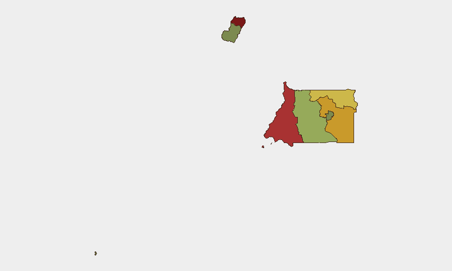
Bioko Norte (risk 85) and Litoral Province (risk 78) drive the national risk profile, driven primarily by geographic proximity to maritime smuggling routes, porous border control, and irregular informal-economy activity rather than active armed conflict or state collapse. Wele-Nzas Province (risk 72), bordering Cameroon and Gabon, faces similar transnational-crime and trafficking pressures. Centro Sur through Annobón show substantially lower scores, reflecting improved state presence or reduced cross-border activity. Security teams should treat these concentrations as chronic structural risk—requiring baseline protective measures and supply-chain resilience—rather than acute, imminent threat requiring evacuation or standdown protocols.
How GeoBit Would Assist
Security teams managing Equatorial Guinea exposure would deploy AOI Monitoring & Early Warning to establish persistent watch over Bioko Norte and Litoral with threshold-based alerting on political, crime, or infrastructure developments. OSINT Fusion & Corroboration (multi-language news, social media, and open-source feeds) would triangulate incident reports to filter noise and confirm escalation. GIS & Spatial Analysis and Routing & Network Analysis would support rapid alternative route planning for supply chains or personnel movement should localized disruption occur. For duty-of-care validation, Intel Sweep and Conflict & Military capabilities would provide peer-firm benchmarking and early warning of regime-stability shifts that might alter the security baseline.
7-Day Outlook
No acute escalation is anticipated in the next 7 days. Equatorial Guinea's low global event frequency and absence of current incident signals suggest conditions will remain stable. Security teams should maintain baseline monitoring posture and review supply-chain redundancy for Bioko Norte and Litoral operations; no operational changes are warranted at this time absent new intelligence.
Highest-Risk Areas — Ranked
| # | State / Region | Risk |
|---|---|---|
| 1 | Bioko Norte | 85 |
| 2 | Litoral Province | 78 |
| 3 | Wele-Nzas Province | 72 |
| 4 | Kié-Ntem Province | 68 |
| 5 | Centro Sur Province | 45 |
| 6 | Bioko Sur | 38 |
| 7 | Djibloho | 15 |
| 8 | Annobón Province | 8 |
Sources
Previous Daily Briefs
A new Equatorial Guinea brief is written every day — each with its own risk map and downloadable CSV. Here's the last week; use the calendar to go further back.
📅 Browse every day by calendar →
Highlighted days have a brief. Tap a day for that day's map & analysis, or “csv” for that day's dataset ($5).
Atlas — our AI intelligence desk — emails them this snapshot personally. Nothing else, no list.