Situation Summary
Eritrea itself has recorded no confirmed security incidents or unrest in the past 24–48 hours. However, heavy fighting in adjacent western Tigray (Ethiopia) on August 2, combined with reported troop massing along the Ethiopia–Eritrea border and unverified social-media claims of Eritrean military presence in Tigray, signal elevated regional conflict risk. The overall threat environment remains volatile owing to militarization of neighboring territories and potential for cross-border spillover, though the domestic security picture inside Eritrea remains stable within the reporting window.
Key Developments
- Shererina, western Tigray (Ethiopia–Sudan border), August 2, 2026. Heavy artillery and drone clashes between Ethiopian federal forces and Tigray rebels broke out around 06:00 local time and persisted until approximately 05:00 August 3 before de-escalating. This is the most significant recent combat event affecting regional stability and border volatility adjacent to Eritrea.
- Northern Tigray–Ethiopia border (southern approach to Eritrea), August 2, 2026. TPLF statements denounced what they termed a "large-scale infantry offensive" by federal authorities, signaling intensified military operations in the theater directly abutting Eritrea's southern frontier.
- Ethiopia–Tigray border (general massing), reported August 2, 2026. Security sources confirm federal troops and Tigrayan forces remain heavily concentrated along the northern Tigray frontier for several months, with mutual accusations of intent to trigger renewed conflict—a backdrop that elevates cross-border risk perception.
- Tigray region, heavy-weapons movement (late July–August 2, 2026). Unverified social-media reporting describes movement of heavy weapons to southern Tigray positions in the context of August 2 Shererina fighting, framed as preparation for operations potentially involving Eritrean coordination; however, major news outlets have not independently confirmed these claims.
- Eritrean military presence claim, Tigray, August 2, 2026. A conflict-tracking X/Twitter account asserted that Eritrean military commanders received a "warm welcome from a TPLF-affiliated network" upon entering Tigray; this assertion lacks corroboration from mainstream media or official sources and should be treated as social-media chatter indicating perceived political–military entanglement rather than a confirmed discrete event.
- Travel advisory reinforcement, last 48 hours. Foreign governments continue to recommend "reconsider your need to travel" to Eritrea overall, citing risk of conflict spillover, heavy militarization of borders, closed land crossings, landmine hazard, and volatile regional conditions—consistent with August 2 developments but not indicative of new incidents on Eritrean soil.
Highest-Risk Areas
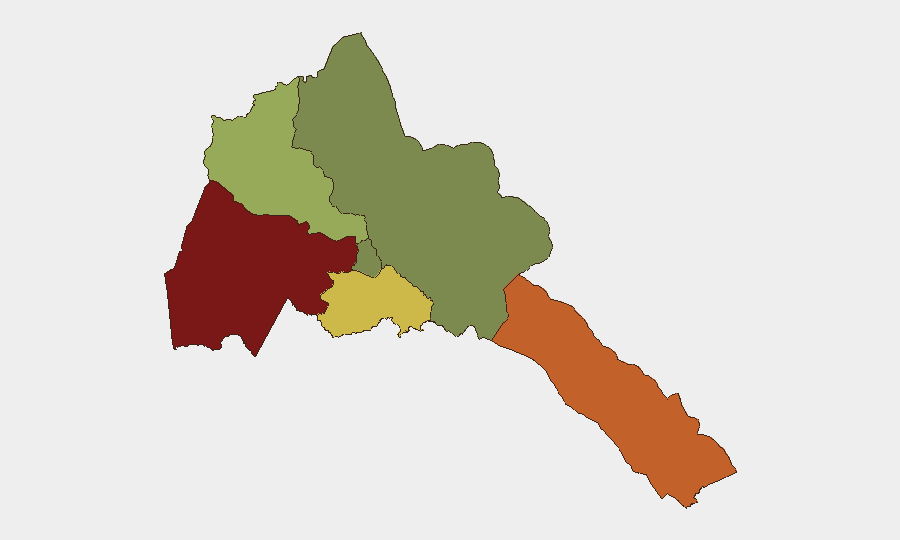
Gash-Barka (western region, risk score 92) and the Southern Red Sea Region (risk score 75) dominate Eritrea's sub-national risk profile and are primarily vulnerable to cross-border spillover from Ethiopia–Tigray conflict. Gash-Barka's proximity to the militarized Ethiopia–Tigray frontier and reported heavy weapons movements in that theater amplify risk; the Southern Red Sea Region faces secondary exposure via potential maritime or eastern-approach escalation. Debub Region (risk score 68) and Anseba (risk score 55) represent moderate secondary concern. Maekel Region (capital, Asmara) and Northern Red Sea Region remain lower-risk, reflecting the concentration of military and conflict activity in the western and southern borderlands rather than in the capital or far north.
How GeoBit Would Assist
Corporate teams would deploy Intel Sweep and multi-language OSINT to track cross-border military movements, AOI Monitoring with persistent alerting on Gash-Barka and the Southern Red Sea Region for early warning of spillover incidents, and Conflict & Military mapping to track Ethiopian–Tigray force dispositions and assess direct threat to Eritrean border positions. Routing & Network Analysis would support alternative journey planning for personnel already in country, and satellite and imagery analysis would corroborate unverified social-media claims regarding weapons staging and troop concentrations.
7-Day Outlook
The August 2 Shererina clashes and reported troop massing suggest the Ethiopia–Tigray theater will remain a flashpoint over the next week, with elevated risk of further localized fighting in border areas abutting Eritrea. Absent new confirmed incidents on Eritrean soil, the domestic security picture is expected to remain stable; however, border volatility and spillover risk will persist, and travel advisories are unlikely to be relaxed in the immediate term.
Highest-Risk Areas — Ranked
| # | State / Region | Risk |
|---|---|---|
| 1 | Gash-Barka | 92 |
| 2 | Southern Red Sea Region | 75 |
| 3 | Debub Region | 68 |
| 4 | Anseba | 55 |
| 5 | Maekel Region | 18 |
| 6 | Northen Red Sea Region | 0 |
Sources
Previous Daily Briefs
A new Eritrea brief is written every day — each with its own risk map and downloadable CSV. Here's the last week; use the calendar to go further back.
📅 Browse every day by calendar →
Highlighted days have a brief. Tap a day for that day's map & analysis, or “csv” for that day's dataset ($5).
Atlas — our AI intelligence desk — emails them this snapshot personally. Nothing else, no list.