Situation Summary
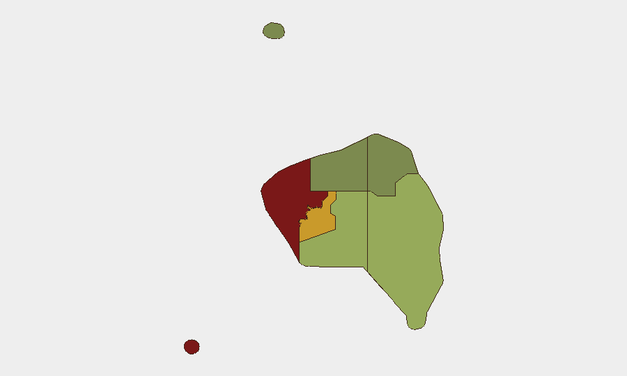
Fiji remains a low-to-moderate global security risk (rank #65, composite score 28) with no tracked armed conflict, civil unrest, or terrorism activity as of 20 August 2026. Current risk is concentrated in localized street crime, road trauma, and maritime hazards rather than organized violence or political instability. The Western division continues to present elevated risk relative to other regions; incidents in the last 48 hours have been isolated and non-systemic.
Key Developments
- Suva, Samabula (Howell Road) — 17 Aug: Police reported a break-in and burglary at a residential premises; cash was stolen and a suspect entered via the main door. Investigation ongoing.
- Nasinu — 17 Aug: Police arrested one of three suspects in connection with a daylight burglary. Charges and custody status not yet confirmed.
- Suva Harbour — 19 Aug: Government launched a US$1 million initiative to remove 17 derelict vessels from the harbour to reduce maritime safety hazards and environmental contamination. Project timeline unspecified.
- Road fatalities — multiple locations, 18–19 Aug: Three separate child pedestrian incidents reported across the greater Suva area (Navua, Nakasi, Narewa) within 24 hours; one fatality (8-year-old) and two hospitalizations recorded. Common factor: vehicles and child crossing exposure. Road conditions, visibility, and driver compliance under informal police review.
- Nadi/Denarau — 19 Aug: Tourism and government stakeholders convened on early-warning protocols for weather-related operational disruption, particularly flooding and cyclone preparedness for the tourism sector.
Highest-Risk Areas
Western division (risk score 85) and Central division (risk score 72) together account for the majority of tracked risk; property crime, burglary, and petty theft cluster in urban centers (Suva, Nadi, Ba). Eastern, Northern, and Rotuma divisions present materially lower exposure. The Western region's elevated score reflects both population density and historical incident clustering; corporate and NGO assets concentrated in Suva and along the Queens Road corridor face proportionally higher exposure to opportunistic theft and break-ins than to organized crime or violence. Road trauma is a secondary but emerging signal affecting all divisions.
How GeoBit Would Assist
Security and duty-of-care teams managing personnel or assets in Fiji would employ GeoBit's AOI Monitoring & Early Warning capability to track incident clusters in high-risk divisions (Western, Central) and receive alerts on new crime, road incidents, or civil-order developments in real time. Routing & Network Analysis would support alternative journey planning for personnel traveling between Suva, Nadi, and regional offices, flagging high-incident segments of Queens Road and urban approach routes. OSINT Fusion & Corroboration ensures that only multi-source verified incidents inform duty-of-care decisions, reducing noise from single-source local reporting.
7-Day Outlook
No material escalation in security risk is anticipated over the next seven days. Road-safety conditions warrant ongoing monitoring, particularly in urban Suva and along main highways, as the recent clustering of child pedestrian incidents may reflect seasonal patterns or temporary hazards (roadwork, visibility). Weather preparedness messaging from government and tourism operators suggests heightened awareness of seasonal flooding risk; corporate teams should confirm business continuity and personnel safety protocols for the October–November storm season.
Highest-Risk Areas — Ranked
| # | State / Region | Risk |
|---|---|---|
| 1 | Western | 85 |
| 2 | Central | 72 |
| 3 | Eastern | 45 |
| 4 | Northern | 38 |
| 5 | Rotuma | 12 |
Sources
Previous Daily Briefs
A new Fiji brief is written every day — each with its own risk map and downloadable CSV. Here's the last week; use the calendar to go further back.
- August 18, 2026
- August 17, 2026
- August 16, 2026
- August 15, 2026
- August 14, 2026
- August 13, 2026
- August 12, 2026
📅 Browse every day by calendar →
Highlighted days have a brief. Tap a day for that day's map & analysis, or “csv” for that day's dataset ($5).
Atlas — our AI intelligence desk — emails them this snapshot personally. Nothing else, no list.