Situation Summary
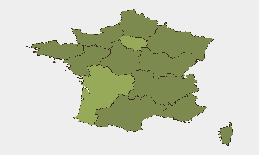
France remains at moderate global risk rank (#42, composite score 42) with 438 tracked events in GeoBit's system. The security environment is currently stable across most of the country, with no major active civil unrest, terrorism incidents, or large-scale infrastructure disruptions confirmed in the last 24–48 hours. Nouvelle-Aquitaine region presents elevated risk (score 59) compared to the national baseline, followed by Île-de-France (41.3), though the immediate threat trajectory appears stable rather than escalating.
Key Developments
- Southern France wildfire (Pyrénées-Orientales, July 6–7, 2026): Large active wildfire near Les Angles forced Tour de France organizers to ban spectators from the Stage 3 finale on safety and emergency-response grounds. Smoke, road closures, and travel disruptions remain possible in the region through event conclusion.
- Multi-jurisdictional maritime incident (July 8, 2026): Small arms combat reported aboard a cargo vessel in French territorial waters or ports; jurisdictional involvement noted between Germany and France as well as Italian administrative sanctions, indicating a cross-border incident with potential customs, trafficking, or security dimensions requiring clarification.
- Territorial dispute activity (July 8, 2026): "Occupy territory" event flagged involving Spain and France; geolocation and scope require rapid clarification to assess whether this signals renewed Pyrenean border tension or a localized administrative/property dispute.
- Military activity (Côte d'Azur region, July 8, 2026): Conventional military force deployment noted in the Riviera area; no hostile indicators confirmed, but warrants monitoring for exercise activity or posturing related to Mediterranean security operations.
- Judicial and political turbulence (July 8, 2026): Multiple judicial rejections, appeals, and disapprovals across French courts and local government (Orléans cited), combined with contradictory public statements from French officials and government commissions, suggest governance friction but no acute institutional breakdown.
Highest-Risk Areas
Nouvelle-Aquitaine's elevated risk score (59) reflects a combination of historical labor disputes, cross-border (Spain) smuggling networks, and periodic wildfire/environmental hazards—the current southern wildfire aligns with this pattern. Île-de-France (41.3) remains the second-highest-risk region owing to its density, critical infrastructure concentration, and historical protest activity; however, current signals do not show acute escalation. The remaining top ten regions (Hauts-de-France, Grand Est, Normandy) cluster in the 29–32 range, suggesting dispersed but manageable risk rather than geographic concentration of acute threat.
How GeoBit Would Assist
Security teams with personnel or assets in Nouvelle-Aquitaine and Île-de-France should activate AOI (area-of-interest) monitoring and alerting to track wildfire progression, road/rail closures, and cross-border movement friction in real time. Multi-language OSINT fusion (Twitter, Telegram, local French media) combined with sentiment and temporal analysis would clarify the intent behind the maritime incident and Spanish-French territorial flag, distinguishing routine administrative disputes from emerging tensions. Satellite and imagery analysis can confirm current wildfire extent and trajectory to inform duty-of-care decisions for event attendance and supply-chain routing.
7-Day Outlook
The wildfire in Pyrénées-Orientales will likely dominate regional risk over the next 7 days; weather patterns and containment will determine travel and infrastructure impact. The maritime and territorial incidents (July 8) require 48–72 hours of additional OSINT confirmation to assess escalation risk; absent new signals, these appear isolated rather than portending wider cross-border friction. France's overall risk trajectory remains stable, with no indicators of imminent terrorism, large-scale civil unrest, or political instability.
Highest-Risk Areas — Ranked
| # | State / Region | Risk |
|---|---|---|
| 1 | Nouvelle-Aquitaine | 59 |
| 2 | Ile-de-France | 41.3 |
| 3 | Hauts-de-France | 32.2 |
| 4 | Grand Est | 30.6 |
| 5 | Normandy | 29.9 |
| 6 | Brittany | 29.7 |
| 7 | Occitania | 29.6 |
| 8 | Centre-Val de Loire | 29.3 |
| 9 | Bourgogne – Franche-Comté | 29.3 |
| 10 | Auvergne-Rhône-Alpes | 29.2 |
| 11 | Provence-Alpes-Côte d'Azur | 29.2 |
| 12 | Pays de la Loire | 29 |
Sources
Previous Daily Briefs
A new France brief is written every day — each with its own risk map and downloadable CSV. Here's the last week; use the calendar to go further back.
📅 Browse every day by calendar →
Highlighted days have a brief. Tap a day for that day's map & analysis, or “csv” for that day's dataset ($5).
Atlas — our AI intelligence desk — emails them this snapshot personally. Nothing else, no list.