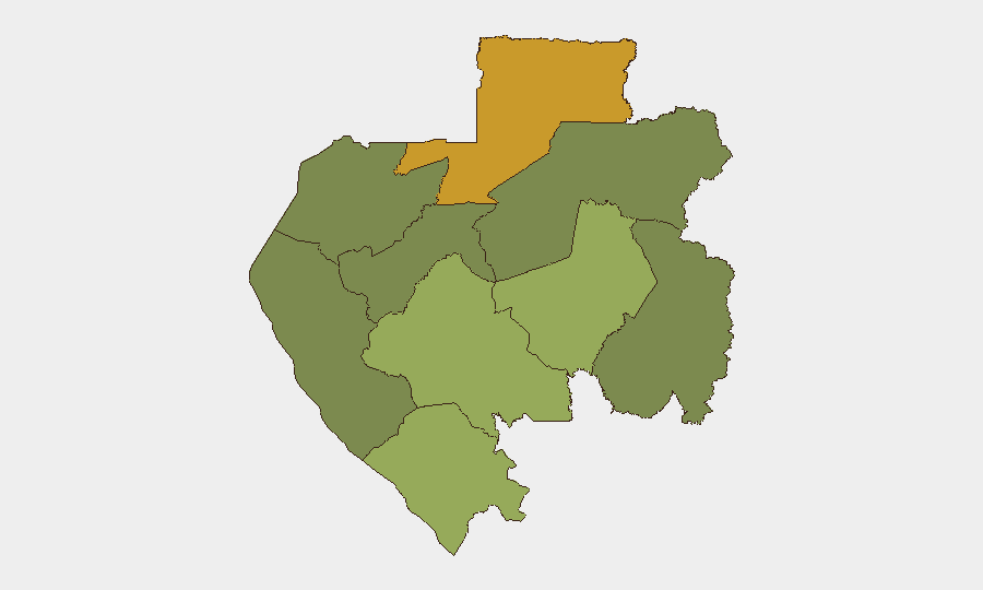
Situation Summary
Gabon remains a low-intensity threat environment at the national level (composite rank #114 globally, score 7/100), with no acute security incidents reported in the last 24–48 hours. Open-source monitoring confirms no significant civil unrest, armed clashes, infrastructure disruption, or travel-risk alerts in recent reporting. Risk is concentrated in northern and eastern border provinces; the capital and coastal regions remain relatively stable.
Key Developments
- Tchibanga, Nyanga Province – 10 July 2026: A security personnel advancement ceremony recognized 36 Gabonese defense and police staff; event proceeded without reported incident or security concern.
No other independently corroborated security, conflict, or stability incidents in Gabon have been reported in the 24–48 hour window. Current regional reporting focuses on neighboring DRC, Nigeria, and maritime piracy; no acute developments in Gabon proper are evident in live web research.
Highest-Risk Areas
Woleu-Ntem Province (northern border, risk score 72) and Ogooué-Lolo Province (eastern interior, risk score 58) drive the national risk profile, likely reflecting cross-border population movement, limited state presence, and proximity to instability in Equatorial Guinea and the Congo Basin. Ngounié, Nyanga, and Haut-Ogooué provinces present moderate risk (scores 42–48), while Estuaire (including Libreville) and Ogooué-Ivindo remain lowest-risk zones. Risk concentration in the north and east suggests border-management, trafficking, or communal tension as primary drivers rather than organized conflict or state fragility.
How GeoBit Would Assist
Teams with personnel or assets in Gabon should employ AOI Monitoring & Early Warning on Woleu-Ntem and Ogooué-Lolo provinces to detect emerging protests, security incidents, or cross-border movement before escalation. Intel Sweep and multi-language OSINT fusion (including X/Twitter, Telegram, and local news sources) would provide continuous corroboration of stability in lower-risk zones (Estuaire, Ogooué-Maritime) and early signals of deterioration in remote provinces. Routing & Network Analysis supports alternative journey planning for staff traveling between Libreville and interior or northern destinations, reducing exposure to highest-risk provinces.
7-Day Outlook
No indicators suggest deterioration in the near term. Routine security operations (such as the 10 July personnel advancement) appear to proceed normally. Monitoring should continue on Woleu-Ntem and Ogooué-Lolo for seasonal border-crossing pressures or transnational movement; absence of recent acute reporting does not eliminate baseline provincial risk, particularly in areas with limited state capacity and cross-border connectivity.
Highest-Risk Areas — Ranked
| # | State / Region | Risk |
|---|---|---|
| 1 | Woleu-Ntem | 72 |
| 2 | Ogooué-Lolo Province | 58 |
| 3 | Ngounié Province | 48 |
| 4 | Nyanga Province | 42 |
| 5 | Haut-Ogooué Province | 35 |
| 6 | Moyen-Ogooué Province | 28 |
| 7 | Ogooué-Maritime Province | 25 |
| 8 | Estuaire Province | 15 |
| 9 | Ogooué-Ivindo | 0 |
Sources
Previous Daily Briefs
A new Gabon brief is written every day — each with its own risk map and downloadable CSV. Here's the last week; use the calendar to go further back.
📅 Browse every day by calendar →
Highlighted days have a brief. Tap a day for that day's map & analysis, or “csv” for that day's dataset ($5).
Atlas — our AI intelligence desk — emails them this snapshot personally. Nothing else, no list.