Situation Summary
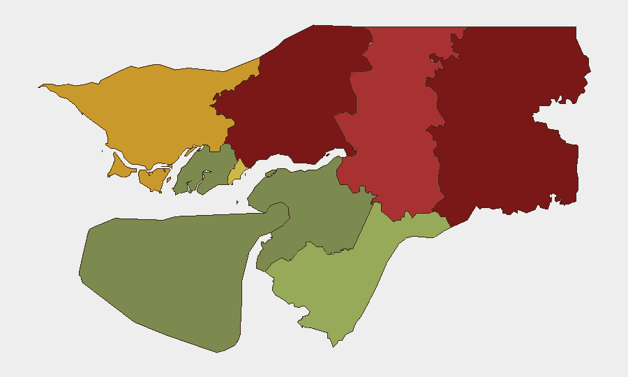
Guinea-Bissau remains a low-intensity, chronic instability environment with composite threat ranking #133 globally and no discrete security incidents confirmed in the last 24–48 hours. The country's risk profile is heavily concentrated in the northern and eastern regions—Gabu, Oio, and Bafatá—where weak state capacity, cross-border trafficking corridors, and historical political fragmentation create persistent vulnerability. The capital and southern zones show materially lower risk, but recurring political tension and military court activity suggest baseline institutional strain.
Key Developments
No clearly verified security or instability incidents have been confirmed inside Guinea-Bissau for 16–17 August 2026 across multiple sources. A single-source report dated 16 August indicates opposition leader Domingos Simões Pereira was returned to prison in Bissau by military court on coup-related charges; however, the exact timing and corroboration status remain unclear and do not meet multi-source confirmation thresholds for this brief. Diaspora protest activity occurred in Paris and Lisbon on 15 August regarding constitutional referendum concerns, but these are external to Guinea-Bissau territory and fall outside the operational 24–48-hour window. No fresh alerts on cross-border trafficking, checkpoint closures, civil unrest, or infrastructure disruption have been detected in available open-source channels.
Highest-Risk Areas
Gabu Region (risk 92) and Oio Region (risk 85) drive the national risk profile and represent the two highest-risk administrative zones in Guinea-Bissau. Both regions share porous borders with Senegal and Guinea proper, enabling narcotics and illicit arms trafficking while also hosting fragmented armed groups and limited state police presence. Bafatá Region (risk 78) and Cacheu Region (risk 72) present intermediate but material risk linked to similar border-trafficking dynamics and sparse governance infrastructure. The Autonomous Sector of Bissau (risk 68) concentrates political and military institutional activity, where court decisions and factional tensions periodically surface; by contrast, the southern regions (Tombali, Quinara, Biombo, Bolama) show substantially lower risk profiles and remain relatively stable for personnel and asset operations.
How GeoBit Would Assist
Security teams should activate AOI (Area-of-Interest) Monitoring & Early Warning on Gabu, Oio, and Bafatá regions to track cross-border movement, checkpoint activity, and armed-group signaling in real time, with alerting on sentiment shifts in Lusophone media and regional social platforms. Parallel Intel Sweep and multi-language OSINT fusion targeting major Lusophone outlets (RFI, Lusa, Observador), government channels, and X/Twitter traffic for Bissau and border corridors will catch emerging political or security developments before they escalate. Network & Actor Analysis of Guinea-Bissau's military leadership and opposition figures provides early warning on factional disputes that often precede instability.
7-Day Outlook
No acute threat trajectory change is evident in the near term; the environment is expected to remain in steady-state chronic instability with routine political friction and low-level trafficking activity. Continued monitoring of military court activity and opposition positioning is warranted given historical coup sensitivity, but no specific trigger events are presently evident. Personnel and asset risk in the capital and southern regions remains manageable under standard duty-of-care protocols; northern and eastern zones warrant heightened situational awareness and travel restrictions.
Highest-Risk Areas — Ranked
| # | State / Region | Risk |
|---|---|---|
| 1 | Gabu Region | 92 |
| 2 | Oio Region | 85 |
| 3 | Bafatá Region | 78 |
| 4 | Cacheu Region | 72 |
| 5 | Bissau Autonomous Sector | 68 |
| 6 | Tombali Region | 45 |
| 7 | Quinara Region | 38 |
| 8 | Biombo Region | 32 |
| 9 | Bolama Region | 15 |
Sources
Previous Daily Briefs
A new Guinea-Bissau brief is written every day — each with its own risk map and downloadable CSV. Here's the last week; use the calendar to go further back.
- August 15, 2026
- August 13, 2026
- August 11, 2026
- August 10, 2026
- August 8, 2026
- August 6, 2026
- August 5, 2026
📅 Browse every day by calendar →
Highlighted days have a brief. Tap a day for that day's map & analysis, or “csv” for that day's dataset ($5).
Atlas — our AI intelligence desk — emails them this snapshot personally. Nothing else, no list.