Situation Summary
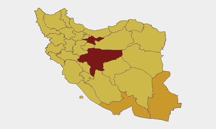
Iran remains at elevated composite threat level (#3 globally, 1023 tracked events YTD) amid concurrent diplomatic negotiations, internal political friction, and persistent regional tensions. U.S.–Iran technical talks in Switzerland (22 June) have reportedly yielded a 60-day roadmap toward a broader accord, including IAEA inspector access and Strait of Hormuz commercial-shipping safeguards, but domestic security incidents—including small-arms combat, coercive action against protesters, and internal political threats (22 June)—indicate continued internal instability independent of diplomatic progress. Tehran Province remains the primary risk driver (100/100), followed by Isfahan (97.3) and a tier of provinces in the south and east (Hormozgan, Sistan and Baluchestan, Ilam) at 70–72.6, signaling distributed rather than isolated vulnerability.
Key Developments
- 22 June, Buergenstock (Switzerland) / Remote Iran Impact: U.S. and Iranian officials agreed to a 60-day diplomatic roadmap; Iranian delegation reportedly accepted IAEA inspector return in principle. Significance: reduces near-term escalation risk but does not address internal coercion or arms-trafficking routes.
- 22 June, Nationwide: Small-arms combat reported; security forces documented coercing protesters. Location(s) unspecified but consistent with ongoing enforcement in Tehran and major urban centers.
- 22 June, Tehran: Internal political threat issued against sitting President; concurrent internal demand (Iranian vs. Iranian). Signals factional tension independent of foreign-policy negotiations.
- 22 June, Mashhad / Lebanon Border Region: Lebanese public statement regarding Mashhad; reduction in Iran–Lebanon media relations (23 June). Reflects spillover from Lebanon ceasefire discussions in Switzerland; commercial and diaspora networks may face disruption.
- 22 June, Diplomatic Level: U.K., Qatar, and Pakistan issued public statements and rejections toward Iran; U.S. Oval Office statement (23 June). Indicates sustained international pressure on nuclear, regional, and human-rights fronts; no imminent military escalation inferred.
Highest-Risk Areas
Tehran Province (100) and Isfahan (97.3) are the primary drivers of composite risk, reflecting concentration of government, economic infrastructure, and enforcement activity. A secondary cluster—Hormozgan, Sistan and Baluchestan, Ilam, West Azerbaijan, and Fars (70–72.6)—spans maritime chokepoints (Hormuz Strait), international borders (Pakistan, Iraq, Turkey), and known trafficking corridors. The persistence of risk across dispersed provinces rather than a single epicenter indicates systemic vulnerability (protest response, inter-factional tension, and transnational smuggling) rather than a localized crisis.
How GeoBit Would Assist
Security teams should leverage AOI Monitoring & Early Warning on Tehran Province, Isfahan, and Hormozgan to track protest sites, security-force positioning, and border crossing activity in near-real time. OSINT Fusion (X/Telegram, multi-language search, entity extraction) and Conflict & Military intelligence enable triage of armed-group communications, factional statements, and protest organization across dispersed populations. Routing & Network Analysis and Alternative Route Planning support duty-of-care teams protecting personnel in high-risk provinces by identifying safe corridors and contingency evacuation paths around active unrest zones.
7-Day Outlook
Diplomatic progress may temporarily reduce state-level escalation risk but is unlikely to suppress internal coercion or factional tension over the next 7 days. Personnel and asset risk in Tehran, Isfahan, and southern provinces (Hormozgan) remains elevated; monitor for spillover from Lebanon ceasefire implementation and any hardline rejection of IAEA inspector protocols. Expect continued security-force activity against protesters and potential tightening of border controls in Sistan and Baluchestan.
Highest-Risk Areas — Ranked
| # | State / Region | Risk |
|---|---|---|
| 1 | Tehran Province | 100 |
| 2 | Isfahan Province | 97.3 |
| 3 | Hormozgan Province | 72.6 |
| 4 | Sistan and Baluchestan Province | 71.2 |
| 5 | Ilam Province | 70.9 |
| 6 | West Azerbaijan Province | 70.9 |
| 7 | Fars Province | 70.6 |
| 8 | Chaharmahal and Bakhtiyari Province | 70.5 |
| 9 | South Khorasan Province | 70.5 |
| 10 | Razavi Khorasan | 70.1 |
| 11 | Bushehr Province | 70.1 |
| 12 | North Khorasan Province | 70 |
Sources
Previous Daily Briefs
A new Iran brief is written every day — each with its own risk map and downloadable CSV. Here's the last week; use the calendar to go further back.
📅 Browse every day by calendar →
Highlighted days have a brief. Tap a day for that day's map & analysis, or “csv” for that day's dataset ($5).