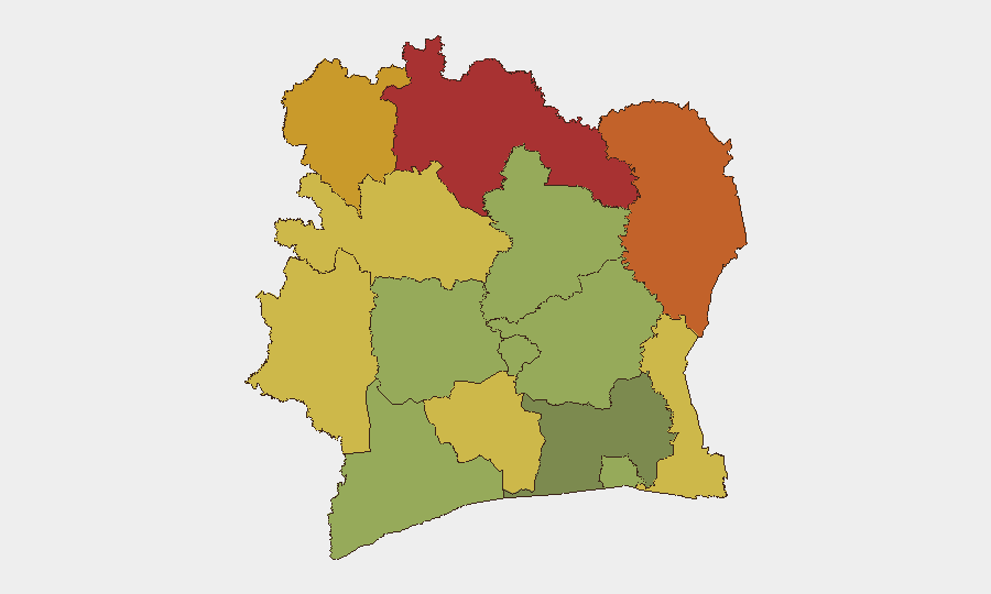
Situation Summary
Ivory Coast remains a moderate global security concern (rank #71, composite score 24) with persistent subnational risk concentrated in the northern savanna and forest districts. Current operational focus is split between post-flood emergency response in Abidjan (ongoing since 29 June) and routine judicial proceedings against opposition figures. No active armed conflict, mass civil unrest, or terrorism incidents are reported in the last 48 hours; the security environment is stable but fragmented by localized humanitarian and enforcement operations.
Key Developments
- Abidjan, Attécoubé district – ongoing emergency operations, 21 July 2026. Red Cross DREF update confirms continuing search, rescue, and displacement management across Attécoubé, Yopougon, Cocody, and Songon following 29 June floods and landslides. Mossikro neighborhood remains the highest-priority zone, with collapsed housing and active slope instability creating persistent travel and shelter risks.
- Abidjan, Mossikro (Attécoubé) – landslide-zone management ongoing, 21 July 2026. The critical landslide impact area where multiple houses were buried on 29 June continues under active humanitarian and risk-management operations. Slope conditions remain unstable; responders and nearby residents face elevated physical hazard.
- Abidjan – housing demolitions in flood-risk zones, mid-July 2026. Forced demolition of informal housing on public land in Attécoubé high-risk flood and landslide areas reported during the week of 14–21 July. Operations are generating localized displacement and potential community tension around enforcement sites.
- Abidjan – release of six PDCI opposition activists, 20 July 2026. Six local opposition officials detained for months were freed following an anti-terrorism chamber hearing. Release eases immediate political-detention tensions but underscores ongoing judicial scrutiny of opposition activities.
- Political-judicial activity flagged, 21 July 2026. GEOBIT event signals note a public statement by DEPUTY targeting Côte d'Ivoire governance or officials on 21 July; insufficient open-source detail available to characterize scope or impact. No street protests or civil unrest reported in response.
Highest-Risk Areas
Northern Savanes, Zanzan, Denguélé, and Comoé districts (scores 78–70) dominate subnational risk, driven by porous borders, weapons trafficking, cross-border militant activity, and weak state capacity in remote areas. Montagnes and Woroba districts (scores 68, 65) present secondary risk from similar drivers. Abidjan, despite its population and economic weight, ranks lower (45) and is currently occupied by humanitarian and infrastructure-recovery operations rather than active conflict; however, its role as the capital and commercial hub means localized disruptions (flooding, enforcement actions, political detention) carry disproportionate national impact.
How GeoBit Would Assist
Security teams monitoring Ivory Coast would employ AOI Monitoring & Early Warning to track subnational risk zones in real time, particularly northern districts and Abidjan flood-recovery areas. Intel Sweep and multi-language OSINT (including Telegram and social-media monitoring) enable rapid detection of civil unrest, detention activity, or armed incidents. Satellite & Imagery analysis can assess infrastructure damage in flood zones and monitor displacement patterns, while Routing & Network Analysis helps identify safe transit corridors around demolition sites and unstable areas.
7-Day Outlook
No major escalation is anticipated in the near term. Post-flood recovery and enforcement operations in Abidjan will likely continue; northern districts will remain under baseline subnational watch. Judicial proceedings against opposition figures may generate periodic political statements but no organized civil unrest is currently signaled. Monitoring intensity should remain elevated for northern border areas and Abidjan humanitarian zones.
Highest-Risk Areas — Ranked
| # | State / Region | Risk |
|---|---|---|
| 1 | Savanes District | 78 |
| 2 | Zanzan District | 75 |
| 3 | Denguélé District | 72 |
| 4 | Comoé District | 70 |
| 5 | Montagnes District | 68 |
| 6 | Woroba District | 65 |
| 7 | Gôh-Djiboua District | 60 |
| 8 | Sassandra-Marahoué District | 58 |
| 9 | Vallée du Bandama District | 55 |
| 10 | Bas-Sassandra District | 52 |
| 11 | Lacs District | 48 |
| 12 | Abidjan | 45 |
Sources
Previous Daily Briefs
A new Ivory Coast brief is written every day — each with its own risk map and downloadable CSV. Here's the last week; use the calendar to go further back.
📅 Browse every day by calendar →
Highlighted days have a brief. Tap a day for that day's map & analysis, or “csv” for that day's dataset ($5).
Atlas — our AI intelligence desk — emails them this snapshot personally. Nothing else, no list.