Situation Summary
Lebanon remains the world's fifth-highest composite threat environment, with 127 tracked events and a composite score of 100. As of 28 June 2026, the country is experiencing acute military escalation in the south and south-central regions, marked by intensive Israeli air operations against Hezbollah targets, cross-border combat, and concurrent civilian displacement. A nascent security deal announced 27 June has not yet arrested hostilities; Israeli drone strikes and ground operations continued on 27–28 June, and institutional rejection by both Israeli and Lebanese military actors signals sustained operational tempo ahead.
Key Developments
- Nabatieh Governorate, 25 June: Israeli airstrikes killed at least 16 civilians overnight; a separate drone strike on a civilian vehicle on the Zawtar–Mayfadoun road killed three and wounded one.
- Southern Lebanon (multiple localities), 24–25 June: Israeli military reported strikes on over 200 Hezbollah targets in 24 hours; residents in Ain Arab were ordered to evacuate by 17:00 local time, after which multiple homes were torched.
- Tyre district / South Governorate, 24–26 June: Civilian displacement accelerated; multiple civilians killed while fleeing on roads in the Tyre–Nabatieh corridor during ongoing air operations.
- Southern Lebanon frontline, 24–26 June: Hezbollah claimed approximately 20 attacks on Israeli troops; Israeli military corroborated roughly 20 Hezbollah attacks against its forces, confirming continued cross-border combat intensity.
- Beirut southern suburbs, 24–26 June: Israel intensified strikes on Hezbollah strongholds despite concurrent diplomatic activity.
- Southern Lebanon healthcare, late June: WHO-reported data indicates nine paramedics killed and five wounded in strikes on healthcare facilities.
- Southern Lebanon, 27 June: Israeli drone strike confirmed post-security-deal announcement, indicating operational continuity despite diplomatic signals.
- Nationwide, 25–28 June: Canadian travel advisory characterizes situation as volatile; road closures to Beirut airport and flight cancellations reported; avoid-all-travel recommendation remains in effect.
Highest-Risk Areas
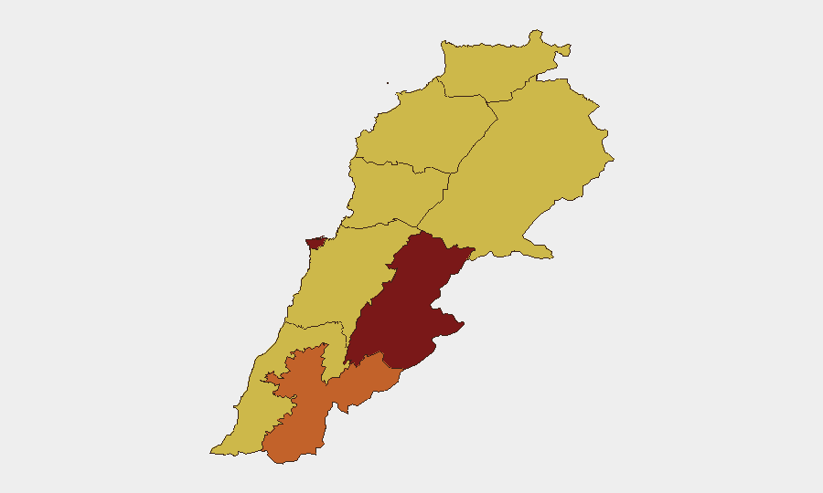
Beqaa Governorate (risk 100) and Beirut Governorate (risk 84) drive the national threat composite, with Beqaa's score reflecting its role as a Hezbollah operational and logistical corridor and Beirut's concentration of state institutions, displaced populations, and contested southern suburbs. Nabatieh Governorate (73.7) ranks third due to current active combat, civilian casualties, and sustained cross-border operations. The southern tier (South, Nabatieh, Baalbek-Hermel, and northern regions) collectively face the highest exposure to aerial bombardment, ground incursions, and displacement, while Mount Lebanon and Keserwan-Jbeil remain elevated (70) due to potential secondary effects and network vulnerabilities.
How GeoBit Would Assist
Security teams should employ AOI Monitoring & Early Warning on Beqaa, Nabatieh, and southern suburbs to detect escalation in real time; Conflict & Military battle mapping and force-structure tracking to anticipate Israeli and Hezbollah operational moves; and Routing & Network Analysis to identify safe transit corridors to Beirut airport and alternative logistics routes as road closures evolve. Satellite & Imagery analysis and OSINT Sweep (X, Telegram, local media) provide ground-truth confirmation of strikes, displacement, and infrastructure damage within 2–4 hours of occurrence, reducing reliance on official statements.
7-Day Outlook
The security deal announced 27 June has not been operationalized; military rejection on both sides and continued strikes suggest a 7–14 day period of volatile negotiations, localized combat, and high civilian risk. Expect sustained airstrikes in the south and periodic ground clashes; displacement may accelerate if a ceasefire timeline is not credibly communicated. Road access to Beirut airport remains unpredictable; corporate teams should anticipate extended flight delays and plan accordingly.
Highest-Risk Areas — Ranked
| # | State / Region | Risk |
|---|---|---|
| 1 | Beqaa Governorate | 100 |
| 2 | Beirut Governorate | 84 |
| 3 | Nabatieh Governorate | 73.7 |
| 4 | North Governorate | 70 |
| 5 | Akkar Governorate | 70 |
| 6 | Keserwan-Jbeil Governorate | 70 |
| 7 | Mount Lebanon Governorate | 70 |
| 8 | South Governorate | 70 |
| 9 | Baalbek-Hermel Governorate | 70 |
Sources
Previous Daily Briefs
A new Lebanon brief is written every day — each with its own risk map and downloadable CSV. Here's the last week; use the calendar to go further back.
📅 Browse every day by calendar →
Highlighted days have a brief. Tap a day for that day's map & analysis, or “csv” for that day's dataset ($5).