Situation Summary
Lithuania faces elevated and sustained air-domain and cross-border security pressures linked to Russia's war in Ukraine and proximate NATO positioning. Over the past week, two confirmed drone intrusions—one shot down by NATO Italian fighters near Lake Kaunas on 15 September, another unalerted incursion on 13 September—underscore persistent airspace violations, likely originating from Belarus. Concurrent with kinetic air-defense activity, domestic law-enforcement responses to hate-motivated incidents (Ukrainian flag vandalism, mosque desecration) and emerging corruption investigations into municipal and political entities signal widening governance and social-cohesion challenges.
Key Developments
- Central Lithuania (Kaunas–Kaišiadorys), drone shootdown – 15 September 2026 (night)
NATO Italian fighter jets from Šiauliai Air Base destroyed an unidentified drone over rural terrain near Lake Kaunas after it entered Lithuanian airspace around midnight, likely from Belarus. Air-raid alerts were declared across Vilnius, Trakai, Elektrėnai, and Kaunas counties; airport operations were temporarily disrupted. Preliminary assessment suggests the drone may have carried explosives.
- Vilnius region, false air-raid alert and airport closure – 13 September 2026
An air-raid alert and temporary closure of Vilnius Airport occurred after radar detection of a suspicious airborne object; NATO scrambled an Italian fighter from Šiauliai. Visual identification later confirmed the object as a bird flock; airport resumed operations after 38 minutes. No marathon disruptions occurred.
- Southern Lithuania (Varėna–Kaliningrad corridor), unalerted airspace incursion – 13 September 2026 (early morning)
An unidentified drone or object traversed 60–70 km of Lithuanian territory in approximately 20 minutes, crossing from the Belarusian border near Varėna toward Kaliningrad Oblast around 04:05. No public alert or fighter scramble was initiated, prompting Defence Minister Robertas Kaunas to demand military explanations regarding detection and response protocols.
- Vilnius (Gediminas Avenue), Ukrainian flag vandalism – night of 14 September 2026
Two intoxicated men removed a Ukrainian flag from a central-Vilnius building flagpole around 03:00. Police detained both suspects (blood alcohol levels 1.49 and 2.43 per mille); investigation opened to assess hate-crime classification.
- Kaunas (Ramybės Park mosque), harassment during prayers – 12 September 2026
A pig's head was brought to the Kaunas mosque during Friday prayers; a biker group gathered nearby playing loud music and chanting. Additional police units deployed; authorities are assessing potential Criminal Code violations for incitement of hatred.
- Vilnius, municipal housing corruption probe – 9–10 September 2026
Lithuania's Special Investigation Service opened a pretrial corruption investigation into Vilnius City Housing (a municipal entity) on suspicion of bribery and offering bribes. A parallel Financial Crime Investigation Service probe is examining fraud, falsified accounting, and document forgery within the same organization.
- National politics (Nemunas Dawn party), financial-crimes searches – 10 September 2026
Financial Crimes Investigation Service conducted searches at homes of five Nemunas Dawn politicians, including Deputy Speaker Daiva Žebelienė, investigating potential misuse of party car-rental funds. No formal charges have been filed.
Highest-Risk Areas
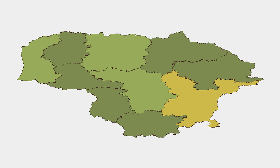
Vilnius County (risk score 68) dominates the threat landscape, reflecting capital-city concentration of administrative, diplomatic, and transport infrastructure alongside documented hate crimes and corruption investigations. Kaunas County (58) and Klaipeda County (52) follow, with Kaunas showing active sectarian tensions (mosque incident) and both counties positioned near border and airspace-defense corridors. The eastern and southern counties (Varėna proximity) experience recurring unalerted drone transits, indicating detection or response gaps in air-sovereignty monitoring.
How GeoBit Would Assist
AOI Monitoring & Early Warning would establish persistent watch over airspace violation corridors (Varėna–Kaliningrad, Kaunas region) with automated alerting on radar anomalies and drone signatures. Intel Sweep and X/Twitter OSINT would track emerging hate-movement narratives and political corruption indicators in real time. Conflict & Military force-tracking and Aviation tracking capabilities would correlate NATO scramble patterns with cross-border incursion frequency to identify systemic detection or response gaps.
7-Day Outlook
Drone incursions are likely to persist at current or elevated frequency given Belarus-based launch infrastructure and limited enforcement cost to operators. Hate-motivated incidents may recur as Ukraine-war tensions intersect domestic xenophobia; police capacity for rapid response appears adequate but sentiment analysis and early-warning systems should monitor online radicalization vectors. Corruption investigations will proceed through pretrial and court phases, creating near-term governance uncertainty in municipal and parliamentary structures.
Highest-Risk Areas — Ranked
| # | State / Region | Risk |
|---|---|---|
| 1 | Vilnius County | 68 |
| 2 | Kaunas County | 58 |
| 3 | Klaipeda County | 52 |
| 4 | Siauliai County | 42 |
| 5 | Panevezys County | 38 |
| 6 | Taurage County | 35 |
| 7 | Utena County | 33 |
| 8 | Alytus County | 32 |
| 9 | Telsiai County | 28 |
| 10 | Marijampole County | 25 |
Sources
Previous Weekly Briefs
A new Lithuania brief is written every Monday, covering the week — each with its own risk map and downloadable CSV. Use the calendar to go further back.
- September 8, 2026
- September 1, 2026
- August 30, 2026
- August 28, 2026
- August 25, 2026
- August 23, 2026
- August 21, 2026
📅 Browse past briefs by calendar →
Highlighted days have a brief. Tap a day for that day's map & analysis, or “csv” for that day's dataset ($5).
Atlas — our AI intelligence desk — emails them this snapshot personally. Nothing else, no list.