Situation Summary
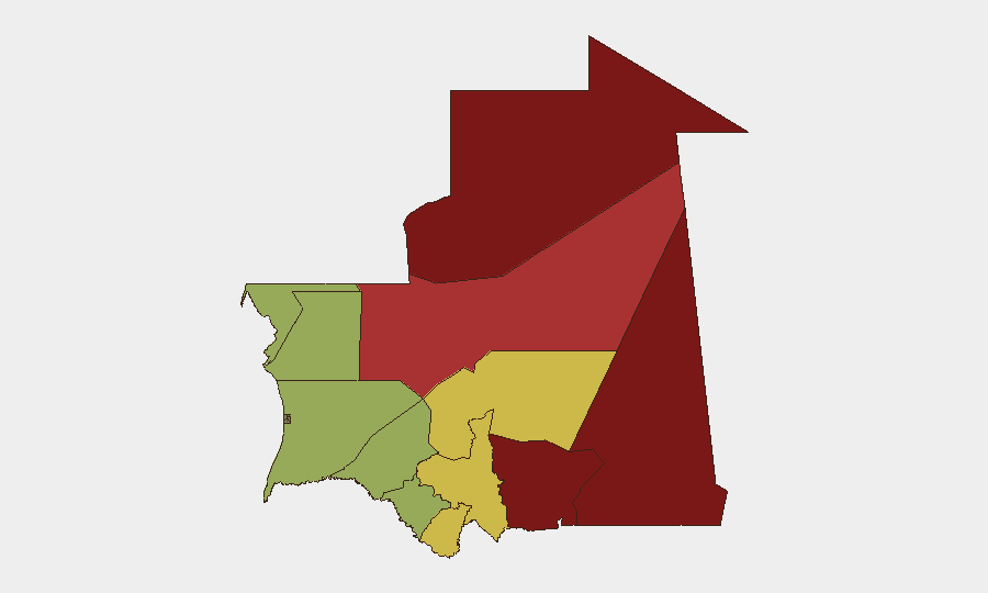
Mauritania remains a moderate-risk operating environment globally (rank #147; composite threat score 8) with no discrete security incidents recorded in the current 24–48-hour window. The country's threat profile is regionally concentrated: terrorism and cross-border activity dominate the northern and eastern frontier zones (Tiris Zemmour, Hodh Ech Chargui), while central and southern regions retain substantially lower risk profiles. Baseline security conditions are stable, but persistent vulnerabilities in remote areas and porous borders with Mali and Algeria warrant continuous monitoring for personnel and asset protection.
Key Developments
No confirmed security, unrest, crime, political-instability, infrastructure, or travel-risk incidents were verified in Mauritania during the last 24–48 hours. Web-based open sources and news feeds did not surface discrete, actionable events in this window. Monitoring should remain active on border crossings (particularly in the northeast) and major transport corridors, where historical patterns show elevated risk; absence of reported incidents does not indicate absence of threat activity in remote zones.
Highest-Risk Areas
Tiris Zemmour (risk 95) and Hodh Ech Chargui (risk 85) dominate the sub-national threat landscape, reflecting documented terrorism presence, weapons smuggling, and irregular militant activity linked to cross-border safe havens in Mali and Algeria. Hodh El Gharbi (80) and Adrar (78) extend this risk arc along the eastern and northeastern borders; these four regions account for the majority of organized threat activity and should be primary focus areas for corporate security teams. Central and southern regions (Brakna, Dakhlet Nouadhibou, Trarza) present substantially lower risk profiles and remain viable for routine operations with standard duty-of-care precautions. Remote desert terrain and limited state presence in the north amplify risks of kidnapping, vehicle ambush, and supply-chain disruption.
How GeoBit Would Assist
AOI Monitoring & Early Warning on Tiris Zemmour and Hodh Ech Chargui border zones would provide persistent watch and alerting for militant movement, camp activity, or incident precursors. Intel Sweep (multi-language OSINT, X/Telegram, sentiment analysis) coupled with Network & Actor Analysis would map known terrorist and criminal networks operating in-country, enabling team leaders to avoid high-risk itineraries and supply routes. Routing & Network Analysis would generate alternative journey plans around confirmed threat clusters, and Satellite & Imagery Analysis would monitor key infrastructure (ports, roads, border posts) for disruption or irregular activity. Real-time multi-language search on Mauritanian media and regional sources fills gaps in English-language news feeds.
7-Day Outlook
No significant escalation is anticipated in the immediate seven-day window absent a major cross-border incident or political shock. Border-zone risk will remain elevated due to seasonal militant activity and weapon flows from Mali; routine operations in central and southern regions should proceed with standard risk controls. Security teams should maintain heightened vigilance on road movements in the east and northeast and confirm real-time local conditions before any travel to remote areas.
Highest-Risk Areas — Ranked
| # | State / Region | Risk |
|---|---|---|
| 1 | Tiris Zemmour | 95 |
| 2 | Hodh Ech Chargui | 85 |
| 3 | Hodh El Gharbi | 80 |
| 4 | Adrar | 78 |
| 5 | Tagant | 68 |
| 6 | Guidimaka | 65 |
| 7 | Assaba | 62 |
| 8 | Gorgol | 58 |
| 9 | Trarza | 55 |
| 10 | Inchiri | 52 |
| 11 | Brakna | 48 |
| 12 | Dakhlet Nouadhibou | 45 |
Sources
Previous Daily Briefs
A new Mauritania brief is written every day — each with its own risk map and downloadable CSV. Here's the last week; use the calendar to go further back.
- August 31, 2026
- August 28, 2026
- August 26, 2026
- August 24, 2026
- August 22, 2026
- August 20, 2026
- August 18, 2026
📅 Browse every day by calendar →
Highlighted days have a brief. Tap a day for that day's map & analysis, or “csv” for that day's dataset ($5).
Atlas — our AI intelligence desk — emails them this snapshot personally. Nothing else, no list.