Situation Summary
Moldova faces elevated airspace security risk stemming from repeated unauthorized Russian drone incursions tied to the ongoing conflict in neighboring Ukraine. Since late August 2026, at least two separate waves of Russian unmanned systems have crossed Moldovan borders, with debris recovered near the capital, prompting official condemnation and announced defense-spending increases. The threat landscape remains primarily one of spillover and intimidation rather than direct kinetic attack, though airspace violations and cross-border drone activity create localized hazards and signal geopolitical friction.
Key Developments
- Five Russian drones cross southern Moldovan airspace, 27 August 2026 (early hours). Unauthorized flights detected near Beleavca–Palanca corridor in Ștefan Vodă district; craft entered and exited Moldovan airspace before returning toward Ukraine during broader Russian strikes on Odesa region. President Sandu publicly characterized incursions as deliberate intimidation on Independence Day anniversary.
- Additional five drone violations detected, night of 27–28 August 2026 (04:00–06:00). Ministry of Defense recorded airspace breaches over Căușeni and Ștefan Vodă districts near Ukraine border; drones subsequently departed into Ukrainian airspace. Incidents represent second confirmed wave within 24 hours.
- Russian "Parody" decoy drone fuselage recovered near Chișinău–Basarabeasca highway, 27 August 2026 (morning, reported 28 August). Debris found roadside near Karabetivka village following collision with tree; police cordoned area and confirmed absence of explosive payload. Physical evidence confirms cross-border drone activity in proximity to major civilian transportation corridor.
- Moldova announces air defense investment and modernization, 28 August 2026. Government statements confirm plans to strengthen air defense systems in direct response to repeated airspace violations, explicitly linking decision to Russian drone incursions and intimidation tactics.
- Russian diplomatic criticism of Moldovan defense spending, 29 August 2026. Deputy Foreign Minister Mikhail Galuzin and Russia's Ambassador in Chișinău issued statements characterizing Moldova's increased military investment as counterproductive to Transnistria settlement and as Western-influenced militarization, elevating rhetorical and diplomatic tension.
Highest-Risk Areas
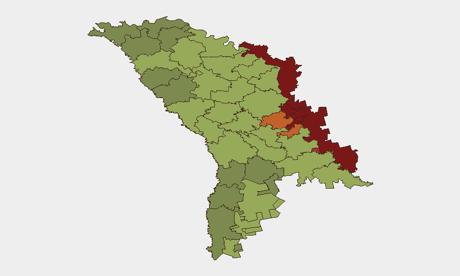
Left Bank Dniester (risk 85) and Dubăsari (82) remain the country's most volatile zones, driven by unresolved Transnistria separatism and Russian military presence. However, the 27–28 August drone incursions have elevated risk profiles in southern border districts—Căușeni (53), Ștefan Vodă (51), and areas near Chișinău (49)—where Ukrainian conflict spillover is now demonstrably occurring. Chișinău and main transport corridors (e.g., Chișinău–Basarabeasca highway) warrant heightened situational awareness due to confirmed unmanned-system debris and ongoing airspace violations near civilian infrastructure.
How GeoBit Would Assist
Corporate security teams should deploy AOI Monitoring & Early Warning on southern border districts and airspace corridors to receive real-time alerts on drone activity and border incursions. OSINT fusion—consolidating aviation tracking, Telegram/X defense-ministry channels, and cross-border incident reporting—provides early indication of new violation waves before official statements. GIS & Spatial Analysis coupled with alternative routing capabilities enables duty-of-care teams to plan travel avoiding high-risk airspace and debris zones near Chișinău–Basarabeasca and other southern routes.
7-Day Outlook
Drone incursions are likely to continue intermittently as Russian strikes on Odesa persist, with southern Moldovan airspace remaining a secondary transit corridor. Russian diplomatic pressure on defense spending may harden into information campaigns or sanctions rhetoric, but no kinetic escalation is imminent. Organizations with personnel or logistics in southern Moldova should assume elevated airspace and border-area risk through early September.
Highest-Risk Areas — Ranked
| # | State / Region | Risk |
|---|---|---|
| 1 | Administrative-Territorial Units of the Left Bank of the Dniester | 85 |
| 2 | Dubăsari | 82 |
| 3 | Bender | 79 |
| 4 | Criuleni | 75 |
| 5 | Rezina | 58 |
| 6 | Taraclia | 55 |
| 7 | Gagauzia | 54 |
| 8 | Căușeni | 53 |
| 9 | Soroca | 52 |
| 10 | Ștefan Vodă | 51 |
| 11 | Orhei | 50 |
| 12 | Chișinău | 49 |
Sources
Previous Daily Briefs
A new Moldova brief is written every day — each with its own risk map and downloadable CSV. Here's the last week; use the calendar to go further back.
- August 26, 2026
- August 24, 2026
- August 22, 2026
- August 20, 2026
- August 18, 2026
- August 15, 2026
- August 13, 2026
📅 Browse every day by calendar →
Highlighted days have a brief. Tap a day for that day's map & analysis, or “csv” for that day's dataset ($5).
Atlas — our AI intelligence desk — emails them this snapshot personally. Nothing else, no list.