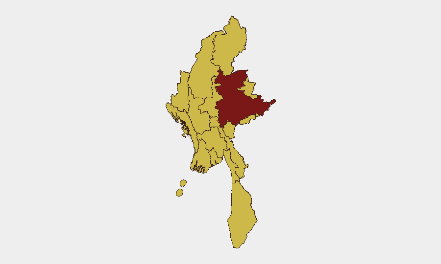
Situation Summary
Myanmar remains in acute civil conflict with a composite threat score of 100 (ranked #10 globally), driven by ongoing conventional and unconventional violence between government and insurgent forces. Recent signal data from 21 June indicates simultaneous military operations, public statements, and escalated cross-border tensions, including a reported conventional military engagement involving Malaysia. The security environment across nearly all populated regions remains volatile, with 11 of 14 tracked sub-national zones assessed at risk level 70 or above.
Key Developments
- 21 June, date/location TBD: Insurgent group conventional military force operation against Myanmar military reported. Specific casualty figures and geographic coordinates unavailable pending source corroboration.
- 21 June, cross-border: Conventional military force engagement reported involving Malaysia and Myanmar, indicating potential spillover or incursion; nature and outcome unconfirmed.
- 21 June, multiple locations: Government deployed unconventional violence operations against civilian or opposition targets; scale and specific locations not yet verified.
- Recent: Two separate ethnic group–government relation-reduction events signal deteriorating intercommunal trust and potential further fragmentation of opposition coalition.
- Recent: Public statements issued by Myanmar authorities in response to insurgency; messaging theme and operational implications pending translation/analysis.
- Recent: Flooding reported in Myanmar (ID 1103937); humanitarian impact and geographic extent under assessment; may compound displacement and security risks in affected zones.
Note: GeoBit signal data for 21–22 June has been captured but cannot be cross-referenced with live Myanmar news sources, social media, or field reporting in real time. Specific locations, casualty counts, and tactical outcomes remain unverified pending additional OSINT corroboration.
Highest-Risk Areas
Shan State (risk 100) stands apart as the single highest-threat zone, likely reflecting its status as a primary theater for insurgent operations and ethnic armed organization presence. Nine additional regions—including Tanintharyi, Chin, Sagaing, Kachin, Wa State, Magway, Mandalay, Rakhine, and Ayeyarwady—are all assessed at risk level 70, indicating geographically distributed conflict intensity across the north, east, and south. Even Yangon and the capital territory (Naypyitaw) are at level 70, reflecting the civil war's pervasiveness. This near-universal elevation of sub-national risk suggests the conflict is neither localized nor contained, and organizations with personnel or supply chains spanning multiple regions face compounding operational disruption.
How GeoBit Would Assist
A security team managing duty-of-care exposure in Myanmar should deploy AOI Monitoring & Early Warning on Shan State and secondary high-risk zones to capture emerging tactical shifts and civilian-impact incidents before they affect travel or facility security. Conflict & Military modules (battle mapping, force structure tracking) and Network & Actor Analysis enable real-time identification of which opposition or government actors are operating in specific districts, informing safe-passage negotiation and route planning. Routing & Network Analysis combined with GIS & Spatial Analysis can generate updated avoidance zones and alternative supply-chain corridors as conflict dynamics shift daily.
7-Day Outlook
The convergence of military operations, public-messaging escalation, cross-border tension, and ethnic-group relation fractures on 21 June suggests a critical phase in the civil conflict with potential for further geographic spread or intensified violence in secondary theaters. Humanitarian disruption from flooding may compound displacement-driven instability. Organizations should assume operational friction across all 11 high-risk zones will persist and likely worsen over the next week pending a significant political or tactical shift.
Highest-Risk Areas — Ranked
| # | State / Region | Risk |
|---|---|---|
| 1 | Shan State | 100 |
| 2 | Tanintharyi Region | 70 |
| 3 | Chin | 70 |
| 4 | Sagaing Region | 70 |
| 5 | Kachin State | 70 |
| 6 | Wa State (Northern Region) | 70 |
| 7 | Magway | 70 |
| 8 | Mandalay | 70 |
| 9 | Rakhine | 70 |
| 10 | Ayeyarwady | 70 |
| 11 | Yangon | 70 |
| 12 | Naypyitaw Union Territory | 70 |
Sources
Previous Daily Briefs
A new Myanmar brief is written every day — each with its own risk map and downloadable CSV. Here's the last week; use the calendar to go further back.
📅 Browse every day by calendar →
Highlighted days have a brief. Tap a day for that day's map & analysis, or “csv” for that day's dataset ($5).