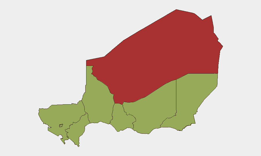
Situation Summary
Niger remains at composite threat rank #27 globally with a score of 71, reflecting persistent instability driven by armed group activity, border tensions, and structural governance challenges. The country's security environment is dominated by threats concentrated in the Sahel north and east, particularly Agadez Region, which carries substantially elevated risk (79.4) compared to other zones. Current open-source signals do not reveal discrete, time-verified security incidents within the last 24–48 hours in Niger proper; ongoing dynamics reflect longer-term patterns of insurgent presence, military operations, and cross-border volatility rather than acute new events. Risk trajectory remains elevated and static absent major policy or operational shifts.
Key Developments
No discrete, location-specific security incidents in Niger with reliable 24–48 hour time verification and corroborating sources are available in current open-source channels. Recent signals in GeoBit's event feed relate primarily to Nigeria (the neighboring state and country) or to longer-running structural tensions (border disputes, military governance, regional insurgency) without a clearly dated incident triggering the alert within the specified window.
Analysts should note: absence of reported incident does not indicate absence of threat. Border areas, remote mining regions, and ungoverned spaces continue to harbor armed groups and criminal networks whose activities may not be immediately visible to open-source collection. Duty-of-care teams should rely on persistent monitoring rather than event-driven alerts for Niger.
Highest-Risk Areas
Agadez Region (79.4) drives the country's overall threat profile and warrants primary focus for corporate security planning. Located in the north-central Sahel, Agadez is a nexus of uranium mining, trafficking routes, and armed-group sanctuary; its risk score significantly exceeds all other regions. Niamey (59.4), the capital, carries secondary but material risk tied to political volatility, protest activity, and concentration of foreign nationals and assets. The remaining six regions (Zinder, Diffa, Tillabéri, Tahoua, Dosso, Maradi) cluster at 49.4, reflecting baseline Sahel-wide exposure to insurgency, banditry, and border permeability, but without the acute designation drivers present in Agadez.
How GeoBit Would Assist
Security teams with personnel or operations in Niger should employ AOI Monitoring & Early Warning to establish persistent watch over Agadez, Niamey, and cross-border corridors, with alert thresholds tuned to armed-group movement, protest mobilization, and checkpoint activity. Conflict & Military tracking combined with Network & Actor Analysis will map evolving armed-group disposition, force posture changes, and governance friction. Routing & Network Analysis supports alternative journey planning and safe-passage logistics for staff or supply convoys, reducing exposure to high-volatility corridors.
7-Day Outlook
No specific near-term catalyst is evident from current signals; security conditions are expected to remain static at elevated baseline levels. Continued vigilance on border tensions (particularly with Algeria, per 25 June diplomatic friction signals) and monitoring of Agadez mining-region stability are warranted. Duty-of-care posture should remain conservative given persistent armed-group presence and limited real-time visibility into remote zones.
Highest-Risk Areas — Ranked
| # | State / Region | Risk |
|---|---|---|
| 1 | Agadez Region | 79.4 |
| 2 | Niamey | 59.4 |
| 3 | Zinder Region | 49.4 |
| 4 | Diffa Region | 49.4 |
| 5 | Tillabéri Region | 49.4 |
| 6 | Tahoua Region | 49.4 |
| 7 | Dosso Region | 49.4 |
| 8 | Maradi Region | 49.4 |
Sources
Previous Daily Briefs
A new Niger brief is written every day — each with its own risk map and downloadable CSV. Here's the last week; use the calendar to go further back.
📅 Browse every day by calendar →
Highlighted days have a brief. Tap a day for that day's map & analysis, or “csv” for that day's dataset ($5).