Situation Summary
Nigeria remains the world's second-highest composite threat environment, driven primarily by active insurgency, organized banditry, and civil unrest across multiple regions. The last 24–48 hours show elevated institutional friction, including public statements directed at law enforcement and government, alongside sanction activity and property seizure incidents. The security landscape is characterized by simultaneous north-south and urban-rural pressure points, with no single dominant driver but rather a diffuse, layered threat matrix spanning terrorism, kidnapping, and state-civil tensions.
Key Developments
- Nigeria (nationwide) — June 27: Administrative sanctions applied to Nigerian entities; media outlets issued sanctions related to Nigeria coverage. Nature and targets of sanctions not fully specified in available signals but indicate elevated government-media or institutional friction.
- Nigeria — June 27: Public dispute between government and police reported; civil actors seized or damaged police property in a separate incident. Pattern suggests deteriorating public confidence in security forces and reactive civil hostility.
- Nigeria — June 27: African regional bodies issued disapproval statements toward Nigeria, suggesting diplomatic or governance concerns beyond domestic security.
- Nigeria — June 26: Two rejection statements issued by Nigerian actors (targets not specified); public statements from Nigerian entities indicate internal disagreement or resistance to policy/directive.
- Oyo & Borno States (background: recent period): Defence Headquarters issued advisory following pupil abductions in both states, indicating sustained school-targeting by armed groups. Latest advisory issued Friday (relative to report date).
- Lagos — June 24: Nigerian Senate passed bill authorizing state-level police forces, a structural response to persistent insecurity but also signaling confidence deficit in federal security apparatus.
- Kwara State (recent, unverified timing): Social media reference to video involving suspected terrorists and security forces; insufficient detail to confirm incident date or operational context within last 48 hours.
Highest-Risk Areas
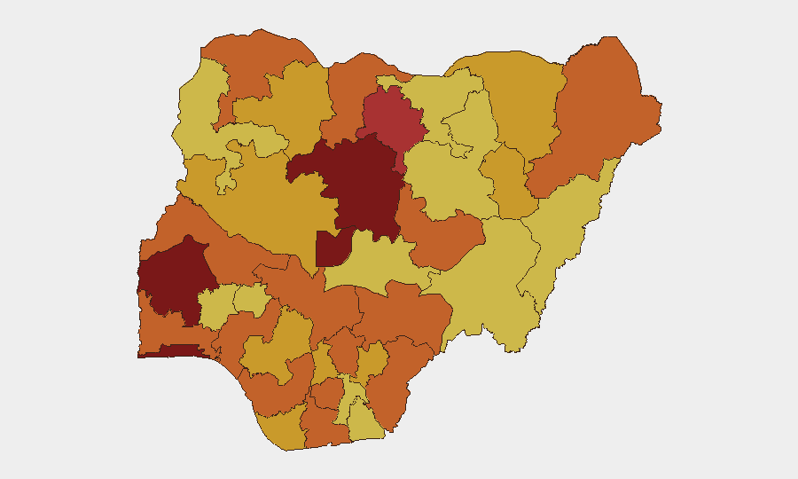
Oyo State (risk 100) now ranks as Nigeria's single highest-risk sub-national zone, reflecting kidnapping, banditry, and institutional instability. Kaduna and Lagos (both 94.8) follow closely, driven by insurgent/bandit activity in the north and high-value asset density and organized crime in the commercial south respectively. The Federal Capital Territory (84.6) and Kano (78.1) remain elevated due to security force engagement patterns and sectarian tensions. The ranking shows no geographic safe zone above 75-point risk; even lower-ranked states (Delta, Sokoto, Kogi) remain in the severe band, indicating nation-wide pressure rather than localized hotspots.
How GeoBit Would Assist
Corporate teams should employ Intel Sweep and multi-language OSINT to track real-time government sanction activity, media restrictions, and police-civil incidents that often precede broader disruption. AOI (Area-of-Interest) Monitoring & Early Warning on Oyo, Kaduna, and Lagos, combined with Conflict & Military battle mapping, enables identification of bandit/insurgent activity corridors and school-zone exposure. Network & Actor Analysis on government-media-police tensions and Sentiment & Temporal Analysis of social signals help anticipate flash-point escalation before property or personnel impact occurs.
7-Day Outlook
The convergence of administrative friction, institutional-civil strain, and sustained abduction activity across multiple states suggests heightened volatility in the near term. School-targeting patterns are likely to persist, and any expansion of state-level police authority (post–June 24 bill) may generate transactional delays and command ambiguity. Security teams should expect continued localized disruption, kidnap risk, and variable law-enforcement response across the priority states through early July.
Highest-Risk Areas — Ranked
| # | State / Region | Risk |
|---|---|---|
| 1 | Oyo State | 100 |
| 2 | Kaduna State | 94.8 |
| 3 | Lagos State | 94.8 |
| 4 | Federal Capital Territory | 84.6 |
| 5 | Kano State | 78.1 |
| 6 | Ogun State | 75.9 |
| 7 | Borno State | 75.7 |
| 8 | Rivers State | 75.1 |
| 9 | Ondo State | 74.9 |
| 10 | Kogi State | 74.9 |
| 11 | Sokoto State | 74.8 |
| 12 | Delta State | 74.6 |
Sources
Previous Daily Briefs
A new Nigeria brief is written every day — each with its own risk map and downloadable CSV. Here's the last week; use the calendar to go further back.
📅 Browse every day by calendar →
Highlighted days have a brief. Tap a day for that day's map & analysis, or “csv” for that day's dataset ($5).