Situation Summary
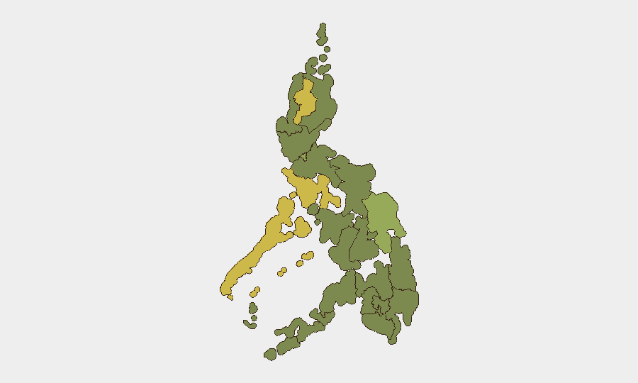
The Philippines remains a mid-tier regional security concern (global rank #41, composite threat score 49) with 67 tracked events, characterized by a mix of localized violence, environmental hazards, and political tensions. Typhoon Inday has triggered cascading natural disasters across Mindanao and the Visayas over the past 72 hours, compounding underlying risks in conflict-prone regions. The most elevated risks are concentrated in the Cordillera Administrative Region, Mimaropa, and Eastern Visayas, while Metro Manila and Central Luzon show moderate but persistent exposure. The security environment shows no signs of acute national destabilization, but localized incidents and weather-driven disruption pose ongoing duty-of-care risks for personnel and supply chains.
Key Developments
- Cotabato City, Bangsamoro Autonomous Region (2026-07-11 to 2026-07-13): Four killed and seven wounded in a series of shootings over the weekend; police heightened checkpoints and initiated investigations, indicating unresolved security gaps in the region.
- Mindanao—Sarangani and Lanao del Norte (2026-07-13): Typhoon Inday–enhanced monsoon rains triggered landslides killing at least 10 people; additional casualties and displacement ongoing as rains persist.
- Lanao del Sur (2026-07-14): A landslide claimed five lives with six reported missing, reflecting severe vulnerability to extreme weather in mountainous terrain.
- North Cotabato (2026-07-13 to 2026-07-14): Flooding caused a bridge collapse, injuring one; critical transportation infrastructure damaged amid ongoing precipitation.
- Pangasinan (2026-07-14): Authorities elevated the province to blue alert status as Typhoon Inday rains continue, indicating elevated operational readiness and anticipated further disruption.
- Western Visayas (2026-07-14): Active flooding and rainfall prompted evacuations and school cancellations, signaling weather-driven mobility and workforce constraints.
Highest-Risk Areas
Cordillera Administrative Region (63.9) and Mimaropa (60.5) drive the highest composite risk scores, reflecting a combination of historical insurgent activity, remote governance, and acute terrain vulnerability to natural hazards. Eastern Visayas (56.2) and Metro Manila (51.5) follow, with the capital's risk driven by density, political exposure, and concentrated critical infrastructure. The current typhoon event has exposed the fragility of Mindanao's road and bridge networks; while Bangsamoro, Caraga, and Northern Mindanao are ranked lower in composite score, their exposure to weather-driven landslides and flooding is demonstrably high. Security teams should prioritize real-time monitoring of Cotabato, Lanao del Sur, and Sarangani as both violence and environmental risk intersect.
How GeoBit Would Assist
Intel Sweep and OSINT fusion capabilities enable continuous monitoring of Philippine security actors, threat networks, and emerging incidents across news, social media, and regional reporting. AOI Monitoring & Early Warning with persistent geographic watch over Cordillera, Mimaropa, Metro Manila, and Bangsamoro regions can alert teams to violence spikes, protest activity, or infrastructure failure before operational impact. GIS & Spatial Analysis and satellite imagery support route planning and assessment of flood/landslide damage to supply chains and personnel transit corridors in real time.
7-Day Outlook
Typhoon Inday is forecast to persist or generate residual rainfall through mid-week, extending landslide and flooding risk across Mindanao and the Visayas. Localized violence in Bangsamoro and Cotabato is likely to remain episodic rather than escalatory, but checkpoints and security operations may constrain movement. Overall threat trajectory remains stable at current level; however, weather-driven disruption will remain the primary operational risk driver through 2026-07-21.
Highest-Risk Areas — Ranked
| # | State / Region | Risk |
|---|---|---|
| 1 | Cordillera Administrative Region | 63.9 |
| 2 | Mimaropa | 60.5 |
| 3 | Eastern Visayas | 56.2 |
| 4 | Metro Manila | 51.5 |
| 5 | Central Luzon | 34.8 |
| 6 | Bicol Region | 34.8 |
| 7 | Bangsamoro | 33.9 |
| 8 | Caraga | 33.9 |
| 9 | Northern Mindanao | 33.9 |
| 10 | Soccsksargen | 33.9 |
| 11 | Davao Region | 33.9 |
| 12 | Ilocos Region | 33.9 |
Sources
Previous Daily Briefs
A new Philippines brief is written every day — each with its own risk map and downloadable CSV. Here's the last week; use the calendar to go further back.
📅 Browse every day by calendar →
Highlighted days have a brief. Tap a day for that day's map & analysis, or “csv” for that day's dataset ($5).
Atlas — our AI intelligence desk — emails them this snapshot personally. Nothing else, no list.