Situation Summary
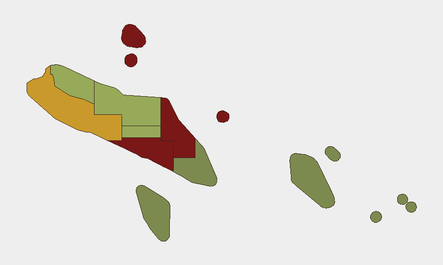
Solomon Islands remains a low–threat environment in global context (rank #139, composite score 7), with no discrete security incidents recorded in the current 24–48-hour window. Recent activity has centred on diplomatic and policy-level developments—notably a government review of the 2022 China security agreement and concurrent efforts to rebalance partnerships with the U.S. and Australia—rather than operational disruptions or civil unrest. Honiara, Guadalcanal, and Malaita carry elevated composite risk scores (92, 88, and 85 respectively), driven by historical patterns of gang activity, inter-communal tension, and crime rather than active current incidents. The security posture reflects diplomatic realignment rather than acute instability.
Key Developments
- Honiara — 10 August 2026 — Prime Minister Matthew Wale announced a government review of the 2022 security agreement with China, pledging increased transparency in binding international agreements and signalling a shift in security-partnership stance.
- Honiara — 7–10 August 2026 — Government officials publicly engaged with diplomatic counterparts on a potential regional security treaty, part of a broader effort to rebalance geopolitical alignment; no operational security incidents reported.
- Nationwide — 7 August 2026 — Officials pursued dialogue to repair relations with the U.S. and Australia, reflecting a policy-level strategic adjustment rather than a response to domestic unrest.
- Honiara — 6 August 2026 — RSIPF drone specialists were selected for a Pacific Islands Forum security deployment to Palau, characterised as routine regional engagement with no domestic security implications.
Note: No acute security, crime, civil-unrest, infrastructure, or travel-disruption incidents were detected in the last 24–48 hours. Activity remains at the diplomatic and administrative level.
Highest-Risk Areas
Honiara (92) and Guadalcanal (88) drive the highest composite risk in Solomon Islands, primarily due to entrenched gang activity, street crime, and sporadic inter-communal friction in and around the capital. Malaita (85) follows, where historical inter-island tensions and weapon caches linked to earlier communal conflict remain a structural vulnerability. Western (72), Choiseul (58), and Isabel (52) carry moderate risk, typically tied to petty crime and limited state capacity. Eastern and southern provinces (Temotu, Rennell and Bellona) remain lower-risk, reflecting smaller populations and lower urbanization. Risk concentration in the capital and Guadalcanal reflects population density, economic activity, and historical flashpoints rather than current acute incidents.
How GeoBit Would Assist
Security teams with personnel or assets in Solomon Islands should use Intel Sweep and OSINT fusion to monitor diplomatic signalling and any cascade effects on security partnerships; AOI Monitoring & Early Warning on Honiara and Guadalcanal to detect early signs of gang escalation or community tension; and Network & Actor Analysis to track relationships between political actors, security agencies, and external partners (China, U.S., Australia) as alliance adjustments unfold. Sentiment & temporal analysis of local media and opposition rhetoric can provide leading indicators of political friction or unrest momentum ahead of formal incidents.
7-Day Outlook
No acute incidents are forecast in the immediate term. Diplomatic realignment will likely continue without operational disruption. Standard due-diligence protocols (local liaison, area-specific travel avoidance in Honiara west-end and Guadalcanal rural zones, and incident-reporting cadence) remain appropriate for corporate teams.
Highest-Risk Areas — Ranked
| # | State / Region | Risk |
|---|---|---|
| 1 | Honiara | 92 |
| 2 | Guadalcanal | 88 |
| 3 | Malaita | 85 |
| 4 | Western | 72 |
| 5 | Choiseul | 58 |
| 6 | Isabel | 52 |
| 7 | Central Province | 48 |
| 8 | Makira-Ulawa | 38 |
| 9 | Rennell and Bellona | 22 |
| 10 | Temotu | 18 |
Sources
Previous Daily Briefs
A new Solomon Islands brief is written every day — each with its own risk map and downloadable CSV. Here's the last week; use the calendar to go further back.
- August 12, 2026
- August 10, 2026
- August 8, 2026
- August 6, 2026
- August 5, 2026
- August 4, 2026
- August 3, 2026
📅 Browse every day by calendar →
Highlighted days have a brief. Tap a day for that day's map & analysis, or “csv” for that day's dataset ($5).
Atlas — our AI intelligence desk — emails them this snapshot personally. Nothing else, no list.