Situation Summary
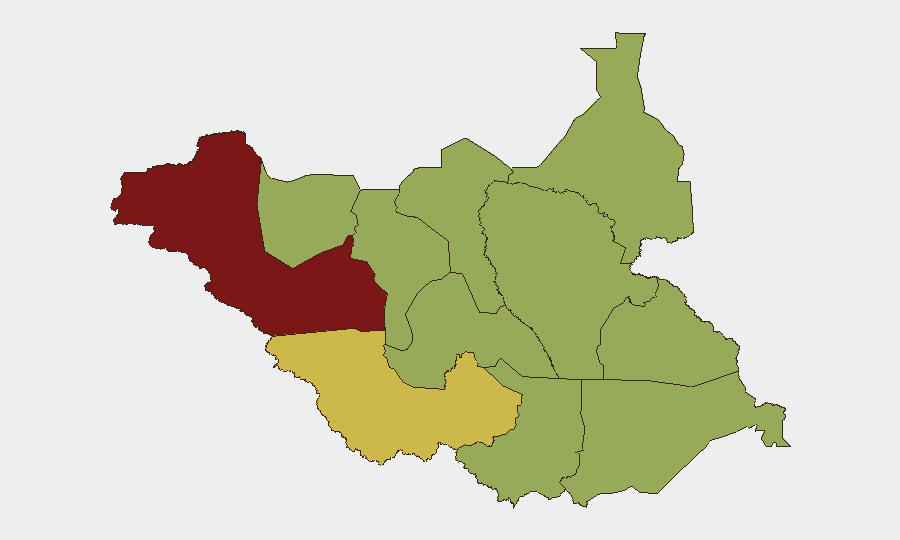
South Sudan remains at elevated risk (global rank #17, composite threat score 73) with ethnic violence and armed factions driving 153 tracked events. The past 48 hours have seen a sharp spike in localized but geographically dispersed incidents: a government official's assassination in Jonglei State, cross-border military clashes in Central Equatoria, and significant civilian displacement near the Uganda frontier. The trajectory is deteriorating in three key zones (Jonglei, Central Equatoria border, and Western Bahr el Ghazal), each with distinct triggers ranging from factional conflict to interstate border tension.
Key Developments
- Bor, Jonglei State – 20 July 2026 (reported 20 July): County commissioner assassinated by opposition fighters in ambush; government sources link killing to escalating factional violence in oil-producing region. Local reporting indicates elevated risk of retaliation attacks in surrounding counties.
- Andeyo border zone, Central Equatoria – 19–20 July 2026: Armed clash between Ugandan People's Defence Force (UPDF) and South Sudan People's Defence Forces (SSPDF) reported near Kaya. SSPDF base damaged by fire during the incident; Ugandan troops reportedly demanded South Sudanese withdrawal from disputed villages before South Sudanese reinforcements repelled the attack.
- Liwolo Payam, Kajo‑Keji County, Central Equatoria – 19–20 July 2026: Bishop of Liwolo and local clergy reported ongoing armed hostilities with approximately 10,000 civilians displaced since mid-July. Fresh displacement movements and sporadic clashes documented on 19–20 July; humanitarian appeal updated over weekend.
- Kajo‑Keji–Uganda border crossings (near Mijale and Liwolo) – 19–20 July 2026: SSPDF security patrols and informal movement restrictions tightened at unofficial crossing points following Andeyo firefight. Commercial transport subjected to enhanced checks as precautionary measure against further cross-border incidents.
- Greater Jonglei feeder roads – 20 July 2026: Humanitarian monitors and conflict observers report heightened fear of reprisal attacks and road insecurity on routes linking Bor to adjacent counties. Aid staff reviewing movement plans; traders delaying travel due to risk of renewed factional clashes.
- Boma‑Badingilo landscape (Eastern Equatoria / Jonglei interface) – 20 July 2026: UNESCO flagged deteriorating security and militarization around wildlife migration corridors; candidate listing "in danger" reflects conflict-driven pressures. Increased poaching and reduced ranger access linked to local military activity.
Highest-Risk Areas
Western Bahr el Ghazal State (risk 81) and Western Equatoria (64.9) dominate the sub-national ranking, driven by sustained ethnic and factional violence. However, the most acute immediate risks are emerging in Jonglei State and the Central Equatoria–Uganda border zone, where the past 48 hours have seen targeted political violence, interstate military clashes, and mass civilian displacement. Upper Nile and Northern Bahr el Ghazal remain elevated (58 and 51 respectively), reflecting ongoing intercommunal tensions and competition for resources.
How GeoBit Would Assist
Security teams should deploy AOI Monitoring & Early Warning on Jonglei State (Bor and surrounding counties), Central Equatoria border zones, and Western Bahr el Ghazal to detect factional movements and cross-border incidents in near-real time. Conflict & Military intelligence (force structure, weapons-capability tracking) and Network & Actor Analysis would clarify opposition faction positioning and government retaliation risk. Routing & Network Analysis would identify safer transit corridors and alternative supply lines avoiding high-risk feeder roads around Bor and Kajo‑Keji.
7-Day Outlook
Reprisal attacks in Jonglei are probable within 72 hours; road security will remain degraded. Border tensions between SSPDF and UPDF may stabilize if political dialogue resumes, but localized clashes and displacement in Kajo‑Keji are likely to continue. Humanitarian access constraints will persist across the three highest-risk zones through at least 26 July.
Highest-Risk Areas — Ranked
| # | State / Region | Risk |
|---|---|---|
| 1 | Western Bahr el Ghazal State | 81 |
| 2 | Western Equatoria | 64.9 |
| 3 | Upper Nile | 58 |
| 4 | Northern Bahr el Ghazal | 51 |
| 5 | Ruweng Administrative Area | 51 |
| 6 | Unity | 51 |
| 7 | Warrap | 51 |
| 8 | Lakes | 51 |
| 9 | Jonglei | 51 |
| 10 | Greater Pibor Administrative Area | 51 |
| 11 | Central Equatoria | 51 |
| 12 | Eastern Equatoria | 51 |
Sources
Previous Daily Briefs
A new South Sudan brief is written every day — each with its own risk map and downloadable CSV. Here's the last week; use the calendar to go further back.
📅 Browse every day by calendar →
Highlighted days have a brief. Tap a day for that day's map & analysis, or “csv” for that day's dataset ($5).
Atlas — our AI intelligence desk — emails them this snapshot personally. Nothing else, no list.