Situation Summary
Suriname presents a composite threat score of 4 with limited verified security incidents in the current 24–48 hour reporting window. No independently corroborated crime, unrest, infrastructure, or political instability events have been detected across major local news outlets or open-source intelligence feeds as of 1 August 2026. The country's risk profile remains baseline, though interior regions and border areas continue to present structural vulnerabilities due to limited state capacity and illicit activity.
Key Developments
No verified security incidents have been reported in Suriname for the period 31 July–1 August 2026. Major local news sources (Waterkant, Starnieuws, ABC-Suriname, Times of Suriname, SRNieuws) contain no fresh crime, unrest, or infrastructure reports dated within the last 48 hours. Global incident aggregators and social media monitoring show similarly negative results for the same window. Two event signals were logged by GeoBit prior to the current reporting period (30–31 July: resident disapproval and a public statement involving SCOT and the Public Prosecutor), but neither has generated cascading security incidents or verified operational impacts within the last 24 hours.
Highest-Risk Areas
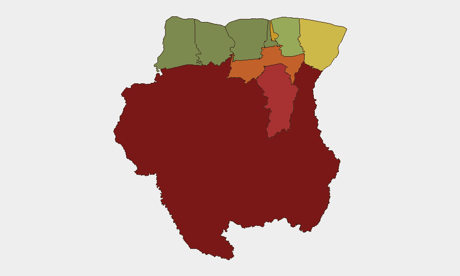
Sipaliwini (risk 92), Brokopondo (risk 78), and Para (risk 74) emerge as the highest-risk districts, reflecting their geographic remoteness, limited law enforcement presence, and known association with illicit mining, smuggling, and trafficking networks operating across borders with Brazil and Guyana. Paramaribo (risk 71) and Marowijne (risk 68) follow, with capital-area risk concentrated in gang-related activity and riverine smuggling routes, while Marowijne's frontier position amplifies cross-border security concerns. The western and coastal districts (Saramacca, Coronie, Nickerie) present substantially lower composite risk scores, indicating more stable operational environments for corporate and expatriate presence.
How GeoBit Would Assist
Security teams operating in Suriname would employ AOI Monitoring & Early Warning to maintain persistent watch on Sipaliwini, Brokopondo, and Paramaribo for emerging trafficking, labor exploitation, or political instability signals. Intel Sweep and multi-language OSINT across local media, social platforms, and Telegram channels would detect localized incidents before they escalate to regional significance. Routing & Network Analysis would support contingency planning for personnel movement, particularly in interior and border regions where road infrastructure and state presence are limited.
7-Day Outlook
No imminent security escalation is forecast for Suriname in the 7-day outlook. Baseline risk posture should be maintained with heightened awareness in interior mining regions and Paramaribo's gang-activity zones. Continued monitoring of border dynamics with Guyana and Brazil is recommended, given persistent structural vulnerabilities around resource competition and irregular migration.
Report Date: 1 August 2026 | Data Currency: 24–48 hours prior | Confidence: Baseline (limited incident volume; interior region coverage constrained by media/reporting gaps)
Highest-Risk Areas — Ranked
| # | State / Region | Risk |
|---|---|---|
| 1 | Sipaliwini | 92 |
| 2 | Brokopondo | 78 |
| 3 | Para | 74 |
| 4 | Paramaribo | 71 |
| 5 | Marowijne | 68 |
| 6 | Commewijne | 42 |
| 7 | Wanica | 38 |
| 8 | Saramacca | 29 |
| 9 | Coronie | 12 |
| 10 | Nickerie | 8 |
Sources
- geobit.ai
- surinamenieuwscentrale.com
- surinamenieuwscentrale.com
- miragenews.com
- surinamenieuwscentrale.com
- srnieuws.com
- surinamenieuwscentrale.com
- surinametimes.com
- surinamenieuwscentrale.com
- surinamenieuwscentrale.com
- surinamesuntimes.com
- newsdata.io
- surinamenieuwscentrale.com
- srnieuws.com
- whitehouse.gov
- surinametimes.com
- seerist.com
- reuters.com
Previous Daily Briefs
A new Suriname brief is written every day — each with its own risk map and downloadable CSV. Here's the last week; use the calendar to go further back.
📅 Browse every day by calendar →
Highlighted days have a brief. Tap a day for that day's map & analysis, or “csv” for that day's dataset ($5).
Atlas — our AI intelligence desk — emails them this snapshot personally. Nothing else, no list.