Situation Summary
Syria remains in the 11th position globally for composite threat exposure, with 820 tracked events reflecting persistent military activity, governance instability, and scattered civil unrest. Recent signals indicate active conventional military operations between state and non-state actors, combined with U.S. counter-ISIS air operations. The threat landscape remains fragmented across multiple governorates, with no clear de-escalation trajectory visible over the current 24–48 hour reporting window.
Key Developments
- Syria-wide — 2026-06-24 to 2026-06-25 — U.S. Central Command conducted an airstrike targeting a senior ISIS leader as part of ongoing counter-terrorism operations; specific location and casualty details pending verification.
- Raqqa Governorate — 2026-06-22 to 2026-06-24 — Security headquarters targeted in an attack resulting in confirmed deaths among security personnel and civilians; incident reflects sustained instability in the eastern region.
- National level — 2026-06-24 — Syrian government issued a public statement regarding a settlement dispute; concurrent civil demonstrations and territory occupation events signaled competing claims over land or resource access.
- Military sector — 2026-06-25 — Multiple reports of conventional military force exchanges between Syrian state forces and Islamic State–aligned fighters across undefined locations.
- Governance/Accountability — 2026-06-24 — Damascus authorities initiated an investigation involving a chief executive, suggesting internal institutional friction or allegation of misconduct.
- Civil unrest — 2026-06-24 — Demonstrations by Syrian civilians against government authority reported; Human Rights Watch issued a disapproval statement on 2026-06-23, indicating documented concerns over conduct.
- Armed opposition — 2026-06-23 — Small arms combat between unidentified fighter groups and Syrian forces noted in event tracking, location unspecified.
Highest-Risk Areas
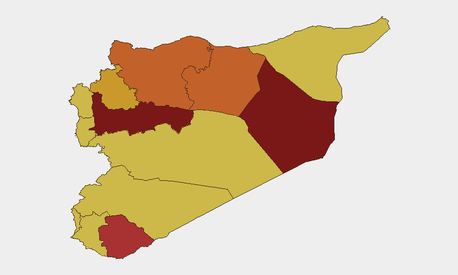
Deir ez-Zor Governorate (99.6 risk score) remains the single most acute threat zone, likely driven by residual ISIS presence, border permeability, and resource competition. Hama and Damascus governorates (84.9 and 83.4 respectively) reflect the concentration of state authority, civilian density, and competing factional interests in central Syria. The UNDOF-monitored buffer zone and southern governorates (As-Suweida, Al-Quneitra, Dar'a) cluster around 69–79 risk, indicating sustained tension in demilitarized or loosely controlled territories. Aleppo, Ar-Raqqa, and northern areas remain volatile due to residual ISIS cells, Turkish-backed operations, and Kurdish autonomous structures.
How GeoBit Would Assist
Security teams with personnel or assets in Syria should deploy GeoBit's AOI Monitoring & Early Warning to establish persistent watches over specific facilities or transit routes in high-risk governorates, with automated alerting on event clustering. Intel Sweep and OSINT fusion across social media, Telegram, and local sources provide continuous baseline intelligence on state/non-state actor positioning and intentions. Battle mapping and force-structure tracking supply near-real-time visibility into military operations and convoy movements, complemented by alternative routing & network analysis to identify safer transit corridors during escalations.
7-Day Outlook
Conventional military operations are expected to persist as U.S. counter-ISIS missions continue and Syrian forces manage residual opposition groups. Civil unrest and governance friction may intensify if investigations yield politically sensitive outcomes or settlement disputes escalate. No major de-escalation is forecast; risk levels are likely to remain elevated across Deir ez-Zor and central Syria over the next week.
Highest-Risk Areas — Ranked
| # | State / Region | Risk |
|---|---|---|
| 1 | Deir ez-Zor Governorate | 99.6 |
| 2 | Hama Governorate | 84.9 |
| 3 | Damascus Governorate | 83.4 |
| 4 | As-Suweida Governorate | 79.6 |
| 5 | Aleppo Governorate | 74.6 |
| 6 | Ar-Raqqa Governorate | 74.6 |
| 7 | Idleb Governorate | 71.7 |
| 8 | Lattakia Governorate | 70.1 |
| 9 | Tartus Governorate | 70.1 |
| 10 | UNDOF | 69.6 |
| 11 | Al-Quneitra Governorate | 69.6 |
| 12 | Dar'a Governorate | 69.6 |
Sources
Previous Daily Briefs
A new Syria brief is written every day — each with its own risk map and downloadable CSV. Here's the last week; use the calendar to go further back.
📅 Browse every day by calendar →
Highlighted days have a brief. Tap a day for that day's map & analysis, or “csv” for that day's dataset ($5).