Situation Summary
Tonga remains a stable, low-threat environment with no reported civil unrest, major crime incidents, or political instability in the past week. The country's security posture is primarily shaped by natural hazards—particularly seismic and volcanic activity inherent to its Pacific location—and by emerging regional cooperation frameworks aimed at transnational crime and maritime security. No acute travel or operational risks have been reported affecting corporate personnel or critical infrastructure.
Key Developments
- Offshore earthquake, Haʻapai group – 1 September 2026, 10:34 UTC
A magnitude 4.9–5.2 offshore earthquake struck approximately 117 km west-northwest of Pangai. No damage, casualties, or tsunami warnings were recorded; routine seismic activity for the region with minimal operational impact.
- US–Pacific Islands Police Ministers Conference – 2 September 2026
The US and Palau announced a new conference on maritime security, drug trafficking, cybercrime, and illicit finance, with Tonga positioned as a key beneficiary. This signals enhanced regional law-enforcement cooperation and potential increases in border-security coordination affecting Tonga's policing architecture.
- Pacific Forum Peace and Security Action Plan endorsement – 3 September 2026
Pacific Forum leaders endorsed a regional action plan targeting transnational crime and security threats. The initiative has direct implications for Tonga's intelligence-sharing protocols, inter-agency coordination, and law-enforcement priorities.
- Volcanic-tsunami early-warning study published – 3 September 2026
A peer-reviewed study on submarine caldera collapse and tsunami generation in Tonga, published in *Phys.org*, highlighted emerging underwater acoustic monitoring techniques. While retrospective, the work underscores ongoing efforts to improve disaster-risk management and early-warning systems for the country.
- No corroborated unrest, crime escalation, or infrastructure failure – week of 1–7 September
Open-source monitoring detected no protests, riots, organized-crime clashes, major theft, terrorism, or significant power/port/airport disruptions tied to security events.
Highest-Risk Areas
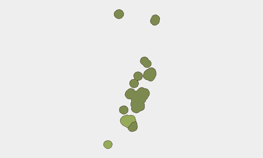
Tongatapu (composite risk score 45) remains the dominant risk driver, reflecting its status as the capital region, largest population center, and primary hub for government, commerce, and international activity. Vavaʻu (risk 28) and Haʻapai (risk 22) follow, likely reflecting exposure to seismic and volcanic hazards and relative geographic isolation. The elevated sub-national scores appear calibrated to natural-hazard susceptibility and infrastructure concentration rather than to active conflict or crime; no geopolitical or social fractures are evident in current reporting.
How GeoBit Would Assist
Intel Sweep and multi-language OSINT fusion provide continuous monitoring for emerging unrest, crime escalation, or policy shifts affecting duty-of-care obligations. AOI Monitoring & Early Warning on Nukuʻalofa and key economic zones (ports, airports, industrial areas) enables real-time alerting to travel disruptions, labor action, or security incidents before they affect operations. Environmental & Health and Satellite & Imagery analysis capabilities support hazard tracking—particularly seismic, volcanic, and tsunami risk—complementing official early-warning channels and informing evacuation or continuity planning for personnel and assets.
7-Day Outlook
No acute security deterioration is anticipated in the near term. Regional policing cooperation frameworks are likely to evolve operationally over coming weeks, potentially affecting visa, port, and telecommunications policy; corporate security teams should monitor official government announcements. Seismic activity will remain routine and endemic; no specific volcano or tsunami alerts have been issued.
Highest-Risk Areas — Ranked
| # | State / Region | Risk |
|---|---|---|
| 1 | Tongatapu | 45 |
| 2 | Vavaʻu | 28 |
| 3 | Haʻapai | 22 |
| 4 | ʻEua | 18 |
| 5 | Ongo Niua | 12 |
Sources
Previous Weekly Briefs
A new Tonga brief is written every Monday, covering the week — each with its own risk map and downloadable CSV. Use the calendar to go further back.
- August 31, 2026
- August 28, 2026
- August 25, 2026
- August 22, 2026
- August 19, 2026
- August 16, 2026
- August 13, 2026
📅 Browse past briefs by calendar →
Highlighted days have a brief. Tap a day for that day's map & analysis, or “csv” for that day's dataset ($5).
Atlas — our AI intelligence desk — emails them this snapshot personally. Nothing else, no list.