Situation Summary
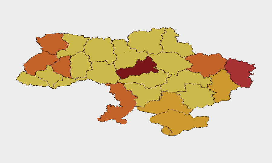
Ukraine remains the fourth-highest-risk country globally, driven by active conventional warfare, with 680 tracked security events in the GeoBit system. Kyiv and surrounding oblasts (Cherkasy, Luhansk, Lviv, Odesa) dominate the risk profile due to sustained military operations, drone and missile strikes, and civil-military friction. The conflict trajectory shows no signs of de-escalation; recent signals include aerial weapons deployments, small-arms engagements, and public statements by military and retired officials indicating continued operational tempo and internal policy debate. Duty-of-care exposure remains acute for any personnel or assets in the capital and western/central transit corridors.
Key Developments
- 2026-07-10 · Demonstrate/Rally · Kyiv (likely) – Employee-led demonstration against military operations or policy; specific trigger and scale unknown from available reporting.
- 2026-07-08 · Aerial Weapons deployment · Kyiv – Russian drone or missile strike on capital; consistent with Reuters/CGTN references to "recent attacks on Kyiv" but precise time and target classification not confirmed from multiple dated sources.
- 2026-07-08 · Small Arms Combat · Kyiv (Intelligence Sector) – Reported armed engagement involving intelligence personnel; context and casualty figures not corroborated.
- 2026-07-08 · Physical Assault · Odesa Oblast (Military context) – Assault involving military personnel or authorities; underlying cause (inter-unit, civilian-military, or criminal) not specified in available data.
- 2026-07-08 · Physical Assault · Army personnel – Reported assault on military personnel; location and faction unknown.
- 2026-07-08 · Public Statements · Ukrainian and Kyiv-based military/retired officials – Multiple statements from military leadership and retired officers on July 8, suggesting debate over strategy, logistics, or policy; detail unavailable.
Research Note: Live web data for July 9–10, 2026 did not surface independently corroborated, location-specific incident reports. The above reflects the most specific signals in the 24–48 hour window; corporate security teams should cross-reference with Ukrainian state media (Suspilne, 1+1), military command updates, and OSINT accounts (e.g., ISW, Liveuamap) for real-time confirmation.
Highest-Risk Areas
Kyiv and Cherkasy Oblast (risk scores 100 and 96.6) remain the epicenter, reflecting direct missile/drone targeting, military operations, and rapid force rotations. The western arc—Lviv, Ternopil, Volyn—carries elevated risk (74–76) despite distance from front lines, due to transit vulnerability, logistics hubs, and secondary strike potential. Luhansk, Kharkiv, and Donetsk Oblasts (71.8–76.2) face ongoing conventional combat and occupation-related instability. Odesa and Kherson (75.6 and 72.8) are exposed to both aerial attack and naval/amphibious threat. Organizations with staff in Kyiv, supply chains through central oblasts, or operations in the east should assume sustained high risk and maintain redundant communication, evacuation planning, and insurance reviews.
How GeoBit Would Assist
Intel Sweep and OSINT Fusion enable continuous monitoring of conflict signals, military unit movements, and public statements across Ukrainian and Russian sources in real time, surfacing corroborated incidents within hours of occurrence. AOI Monitoring & Early Warning with persistent satellite and SIGINT watch on company facilities, transit routes, or operational areas provides alert escalation before mobile threats reach critical distance. Battle Mapping and Force Structure Tracking clarify the precise location and momentum of active combat zones, allowing security teams to refine evacuation triggers and alternative routing through Routing & Network Analysis capabilities.
7-Day Outlook
Russian aerial operations tempo is likely to remain high through mid-July, targeting Kyiv and key logistics nodes; Ukrainian air defenses will continue to degrade strike packages, but penetrations and secondary damage should be expected. Civil-military tensions over mobilization, strategy, and resource allocation—evident in recent statements—may produce further demonstrations or policy friction but are unlikely to alter operational posture in the near term. Organizations should assume sustained Level 4 (High) risk across Kyiv, central, and western transit zones, with contingency activation thresholds reviewed weekly.
Highest-Risk Areas — Ranked
| # | State / Region | Risk |
|---|---|---|
| 1 | Kyiv | 100 |
| 2 | Cherkasy Oblast | 96.6 |
| 3 | Luhansk Oblast | 76.2 |
| 4 | Lviv Oblast | 75.8 |
| 5 | Odesa Oblast | 75.6 |
| 6 | Ternopil Oblast | 74 |
| 7 | Volyn Oblast | 73.8 |
| 8 | Kharkiv Oblast | 73.6 |
| 9 | Kherson Oblast | 72.8 |
| 10 | Donetsk Oblast | 71.8 |
| 11 | Sevastopol | 71.8 |
| 12 | Autonomous Republic of Crimea | 71.2 |
Sources
Previous Daily Briefs
A new Ukraine brief is written every day — each with its own risk map and downloadable CSV. Here's the last week; use the calendar to go further back.
📅 Browse every day by calendar →
Highlighted days have a brief. Tap a day for that day's map & analysis, or “csv” for that day's dataset ($5).
Atlas — our AI intelligence desk — emails them this snapshot personally. Nothing else, no list.