Situation Summary
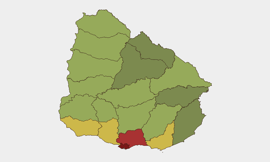
Uruguay remains a regional security outlier in South America, ranking #173 globally with a composite threat score of 4—substantially lower than neighbouring countries. The security environment is characterized by concentrated urban crime in Montevideo and surrounding departments, alongside ongoing government counter-organized-crime operations. The country's political stability and institutional strength continue to mitigate broader regional volatility, though drug-trafficking infrastructure and localized gang activity persist in specific high-density zones.
Key Developments
GeoBit's event signals from 2026-07-04 to 2026-07-05 include administrative action at an educational institution (2026-07-04), territory occupation linked to media activity (2026-07-05), and multiple public statements from Uruguayan authorities and diplomatic exchanges with Venezuela (2026-07-05). Current live-web research has not corroborated specific, geographically-precise security incidents (armed confrontations, infrastructure failures, mass protests) within the last 24–48 hours in Uruguay itself. Broader context: government coordination with Chilean authorities and deployment of armored vehicles (Mamba MK-7) in high-crime Montevideo neighborhoods reflects sustained counter-crime posture but predates the current 24–48 hour window. No confirmed travel disruptions, port closures, or civil unrest affecting corporate operations have been identified in the last two days.
Highest-Risk Areas
Montevideo (risk 92) and Canelones (risk 78) dominate the sub-national risk landscape and account for the majority of recorded security events. Both departments are centers of organized-crime activity, street-level gang violence, and drug-trafficking logistics; Montevideo's density, informal settlements (particularly in the south and northwest), and port proximity create persistent vulnerability to organized-crime networks and extortion. Maldonado (risk 68) and San José (risk 64) rank third and fourth, likely reflecting tourism-corridor exposure and smaller-city gang presence. All other departments score below 65, indicating that risk is heavily concentrated in the metro area and immediate surroundings; corporate assets and personnel outside the Montevideo–Canelones corridor face substantially lower threat levels.
How GeoBit Would Assist
Security teams protecting assets and personnel in Uruguay would prioritize Area-of-Interest Monitoring & Early Warning on Montevideo's highest-incident neighborhoods and key transport corridors to detect emerging gang activity or extortion campaigns. Intel Sweep and multi-language OSINT fusion (X/Twitter, Telegram, local news) enable 24/7 detection of localized civil unrest, police actions, or criminal organization public statements affecting specific districts. Routing & Network Analysis and GIS spatial tools support daily journey planning for staff, identifying real-time detours around active crime scenes or checkpoints. Regular Risk & Threat Assessment updates on organized-crime actor networks and port-adjacent smuggling activity inform longer-term facility and supply-chain decisions.
7-Day Outlook
No acute escalation in Uruguay's national or regional security posture is indicated in the next seven days. Montevideo and Canelones will likely remain the focus of routine police operations and gang-related incidents; personnel in those zones should maintain standard travel security protocols and situational awareness. Diplomatic and administrative activity (noted in event signals) does not presently suggest policy shifts that would materially alter the threat baseline.
Highest-Risk Areas — Ranked
| # | State / Region | Risk |
|---|---|---|
| 1 | Montevideo | 92 |
| 2 | Canelones | 78 |
| 3 | Maldonado | 68 |
| 4 | San José | 64 |
| 5 | Colonia | 62 |
| 6 | Soriano | 58 |
| 7 | Río Negro | 56 |
| 8 | Salto | 54 |
| 9 | Artigas | 52 |
| 10 | Paysandú | 50 |
| 11 | Florida | 48 |
| 12 | Flores | 46 |
Sources
Previous Daily Briefs
A new Uruguay brief is written every day — each with its own risk map and downloadable CSV. Here's the last week; use the calendar to go further back.
📅 Browse every day by calendar →
Highlighted days have a brief. Tap a day for that day's map & analysis, or “csv” for that day's dataset ($5).
Atlas — our AI intelligence desk — emails them this snapshot personally. Nothing else, no list.