Situation Summary
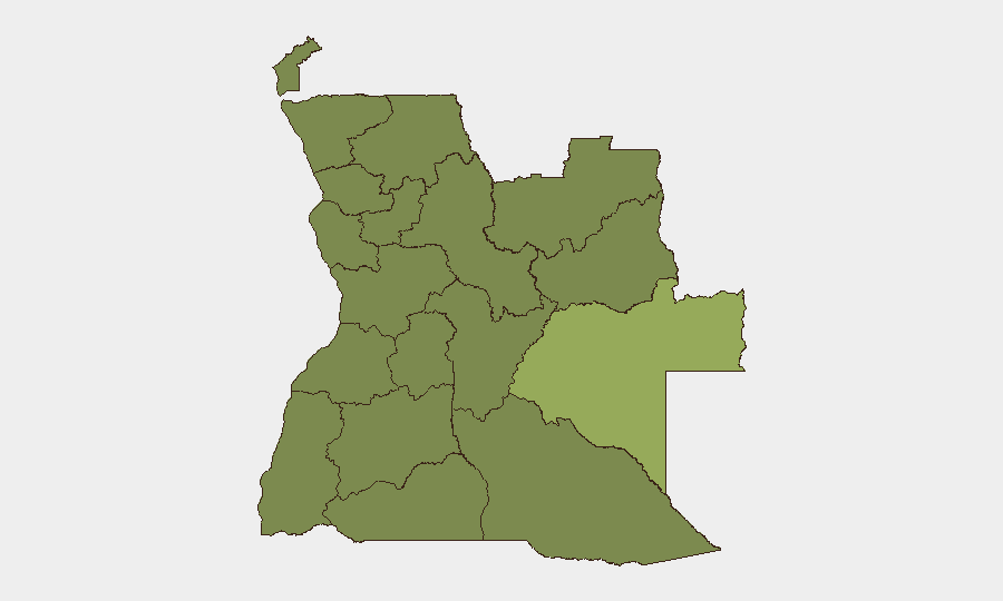
Angola remains a moderate-risk environment (global rank #51) with a composite threat score of 39 and 1,940 tracked events, reflecting endemic crime, regional instability, and infrastructure vulnerabilities rather than acute national crisis. The security picture is characterized by localized friction—police detention activity, natural hazards (seismic, cholera), and diplomatic posturing from neighboring actors—without indicators of imminent systemic breakdown or widespread civil unrest in the last 48 hours. Risk is heavily concentrated in the eastern provinces, particularly Moxico, where mining operations, border permeability, and limited state presence create persistent exposure to organized crime and transnational threats.
Key Developments
- 2026-07-09 · Police Detention Activity (Nationwide): Arrest/detain operations by Angolan police recorded; no specific location or victim count disclosed in available reporting. Typical of routine law-enforcement activity but worth monitoring for scale or targeting of specific groups.
- 2026-07-10 · Regional Diplomatic Friction (Africa): Moroccan disapproval statements directed at broader African actors and continental issues; no direct Angola-specific diplomatic incident confirmed, but reflects regional political tension that can affect border management and transnational cooperation.
- Seismic Event (Lucapa, Lunda Norte): Magnitude 4.4 earthquake recorded ~154 km northeast of Lucapa (recent, date unspecified); low immediate risk but signals tectonic instability in diamond-mining heartland; monitor for secondary infrastructure or operational disruption.
- Cholera Alert (Angola, National): Active cholera event ongoing; specific province, case count, and mortality unconfirmed in 24-hour news cycle. Public-health risk to personnel, particularly in Moxico and Lunda provinces where water and sanitation infrastructure is weak.
- No Major Civil Unrest, Conflict, or Infrastructure Failures (Last 48 Hours): Open-source news and social-media monitoring confirm absence of reported riots, insurgent attacks, major protests, or nationwide service disruptions in the period 9–11 July 2026.
Highest-Risk Areas
Moxico Province dominates the risk landscape (score 57.4)—more than double the national average—due to its remote location, porous borders with Zambia and the Democratic Republic of Congo, and dependence on artisanal and informal mining. A second tier of nine provinces (Lunda Norte, Lunda Sul, Cabinda, Zaire, Bengo, Luanda, Uíge, Cuanza Norte/Sul, Malanje, and Bié) cluster at score 27.4, indicating systemic vulnerabilities: weak governance capacity, organized-crime activity, human trafficking, and smuggling networks. Luanda and Bengo, despite urban status, carry elevated risk due to crime concentration and informal-settlement volatility; the Lundas remain critical due to diamond-sector instability and illicit-trade exposure.
How GeoBit Would Assist
Teams with personnel or assets in Angola should leverage AOI Monitoring & Early Warning for persistent watch on Moxico, Lunda, and Cabinda provinces, with automated alerting on detention sweeps, border-crossing incidents, or health emergencies. OSINT Fusion (multi-language web search, X/Telegram intelligence, and radio SIGINT) enables real-time tracking of informal mining disruptions, trafficking flows, and police activity that rarely appear in formal news. Routing & Network Analysis helps corporate security plan alternative travel corridors to avoid high-risk zones and identify supply-chain bottlenecks during unrest.
7-Day Outlook
No acute escalation is forecast for the next week absent external shocks (e.g., major diamond-sector conflict, transnational spillover from DRC). Cholera containment and police-detention trends warrant close monitoring. Routine crime and informal-economy volatility will likely persist as baseline risk drivers.
Highest-Risk Areas — Ranked
| # | State / Region | Risk |
|---|---|---|
| 1 | Moxico Province | 57.4 |
| 2 | Lunda Norte Province | 27.4 |
| 3 | Lunda Sul Province | 27.4 |
| 4 | Cabinda Province | 27.4 |
| 5 | Zaire Province | 27.4 |
| 6 | Bengo Province | 27.4 |
| 7 | Luanda Province | 27.4 |
| 8 | Uíge Province | 27.4 |
| 9 | Cuanza Norte Province | 27.4 |
| 10 | Cuanza Sul Province | 27.4 |
| 11 | Malanje Province | 27.4 |
| 12 | Bié Province | 27.4 |
Sources
Previous Daily Briefs
A new Angola brief is written every day — each with its own risk map and downloadable CSV. Here's the last week; use the calendar to go further back.
📅 Browse every day by calendar →
Highlighted days have a brief. Tap a day for that day's map & analysis, or “csv” for that day's dataset ($5).
Atlas — our AI intelligence desk — emails them this snapshot personally. Nothing else, no list.