Situation Summary
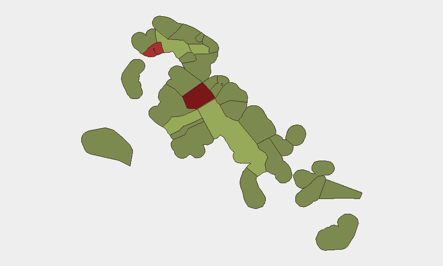
The Bahamas remains a moderate-risk jurisdiction (global rank #72, composite score 21) with elevated violent-crime concentrations in New Providence and Freeport. August has recorded four fatal shootings and one construction-worker homicide across Nassau, with two incidents occurring on West Bay Street within 24 hours (3–4 August). No confirmed new security incidents have been reported in the past 24–48 hours; baseline violent-crime and property-crime exposure persists, particularly in high-density urban and informal-settlement areas.
Key Developments
- No new confirmed incidents, 2026-08-07 to 2026-08-08. Open-source monitoring across police releases, local news, and social-media channels detected no discrete security, civil-unrest, or crime event in the last 24–48 hours.
- Baseline elevated homicide activity through early August. Four fatal shootings (West Bay Street ×2, Wilson Tract, Trading Liquor Store vicinity) and one targeted killing of a 71-year-old construction worker occurred between 1–7 August; perpetrators and motives remain unspecified or unknown in most cases, consistent with ongoing gang-related and interpersonal violence patterns.
- Blue Hills infrastructure and civil tensions (1 August, context for current environment). Lightning-triggered power-station explosion and government demolition of 64 shantytown structures created localized civil unrest and assault on task-force personnel; infrastructure restoration status unclear, with implications for service continuity and social stability in the affected district.
- Residential fire fatality (3 August, context). Single-fatality house fire on Palmetto Avenue; police investigation ongoing but assessed as non-security incident.
Highest-Risk Areas
New Providence (risk 92) and City of Freeport (risk 78) represent the primary threat-concentration zones, driven by concentrated violent-crime activity, gang presence, and infrastructure vulnerabilities. New Providence—which includes Nassau—accounts for the majority of reported August homicides and has sustained elevated baseline crime in West Bay Street and Wilson Tract areas. Freeport's risk score reflects similar violent-crime exposure and property-crime patterns. Secondary-risk zones include Central Abaco (52), Central Andros (48), and Exuma (45), where lower reporting frequency masks latent crime and maritime-border permeability; corporate operations in these areas warrant equivalent duty-of-care protocols as major urban centers.
How GeoBit Would Assist
Security and risk teams should employ AOI Monitoring & Early Warning on New Providence and Freeport to detect emerging incident clusters and crime-pattern shifts in real time. Intel Sweep and multi-source OSINT (X/Twitter, local radio, police bulletins, and Telegram) provide early detection of developing civil unrest, gang activity, and infrastructure failures before they escalate. GIS & Spatial Analysis enables identification of safe routing and asset-location risk stratification by sub-national district, supporting duty-of-care evacuation and personnel-movement protocols.
7-Day Outlook
Violent-crime activity is expected to remain elevated in New Providence and Freeport through mid-August, with no apparent de-escalation drivers visible. Blue Hills civil tensions may persist, particularly if demolition operations resume or service-restoration delays continue. Personnel and asset-security posture should remain at current vigilance level, with emphasis on West Bay Street avoidance and after-hours movement restrictions in high-risk districts.
Highest-Risk Areas — Ranked
| # | State / Region | Risk |
|---|---|---|
| 1 | New Providence | 92 |
| 2 | City of Freeport | 78 |
| 3 | Central Abaco | 52 |
| 4 | Central Andros | 48 |
| 5 | Exuma | 45 |
| 6 | East Grand Bahama | 42 |
| 7 | South Andros | 38 |
| 8 | North Abaco | 35 |
| 9 | North Eleuthera | 33 |
| 10 | South Abaco | 32 |
| 11 | Cat Island | 30 |
| 12 | Mangrove Cay | 28 |
Sources
Previous Daily Briefs
A new Bahamas brief is written every day — each with its own risk map and downloadable CSV. Here's the last week; use the calendar to go further back.
📅 Browse every day by calendar →
Highlighted days have a brief. Tap a day for that day's map & analysis, or “csv” for that day's dataset ($5).
Atlas — our AI intelligence desk — emails them this snapshot personally. Nothing else, no list.