Situation Summary
Bahrain is experiencing an acute security crisis driven by Iranian cross-border missile and drone attacks that began early Saturday, August 2, 2026, and continued through August 3. Air defences have intercepted multiple waves of Iranian aerial strikes targeting military and civilian infrastructure, with no new strikes reported in the most recent 12–24 hours, though the threat environment remains highly volatile. Regional governments, the US State Department, and international travel advisories have all escalated warnings, citing unpredictable escalation risk and the potential for further Iranian attacks.
Key Developments
- Manama, early Saturday, August 2, 2026 – Bahrain's Foreign Ministry confirmed that Iranian drones targeted Bahraini territory at dawn; US officials reported Iran simultaneously launched multiple missiles and drones toward Bahrain and Kuwait.
- Nationwide, Saturday–Sunday, August 2–3, 2026 – Bahrain's Defence Force reported interception of a second wave of Iranian aerial attacks; air-raid sirens sounded and residents were directed to secure shelters; BDF declared readiness at "the highest levels."
- Manama and key infrastructure zones, August 2–3, 2026 – Multiple regional sources documented explosions and siren activity following Iranian strikes; no new overnight strikes reported in the 12–24 hour window prior to this brief, but sustained alert posture maintained.
- US diplomatic mission and expatriate community, August 2–3, 2026 – US State Department issued security alerts to missions in Bahrain warning of "significant escalation" involving Iran; worldwide caution notices shared with US embassies across the region.
- Travel advisory update, August 2–3, 2026 – Australia's Smartraveller advisory escalated to "reconsider your need to travel" due to unpredictable security situation, citing risk of further drone/missile strikes and impact on civil aviation and ports.
- Civil-protection measures, late July–August 3, 2026 – Interior Ministry air-raid siren protocols remain active and are being re-circulated as part of ongoing civil-protection response.
Highest-Risk Areas
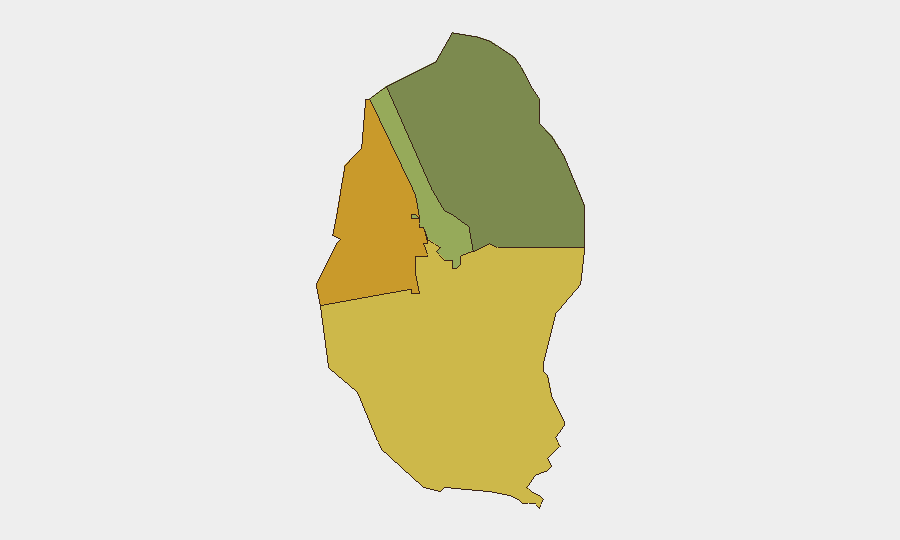
The Northern and Southern Governorates carry the highest composite risk (72 and 68, respectively), likely reflecting proximity to contested maritime boundaries and Iranian staging areas, as well as concentration of critical infrastructure and military installations. The Capital Governorate (Manama and surroundings, risk 45) has become a focal point of Iranian strikes and remains under active threat from drone and missile activity. Muharraq Governorate (risk 38) presents lower but sustained risk. Overall sub-national variation reflects infrastructure concentration and cross-border attack vectors rather than internal unrest; no credible reports of domestic civil instability or routine crime escalation exist in the current 24–48 hour window.
How GeoBit Would Assist
Security teams with personnel or assets in Bahrain should deploy AOI Monitoring & Early Warning on the Northern and Capital Governorates to detect Iranian launch signatures and siren activations; Conflict & Military tracking (battle mapping, force-structure updates, weapons-capability data) to monitor BDF air-defence posture and Iranian drone/missile profiles; and Maritime & Aviation tracking to identify movement patterns and no-fly zones affecting business continuity. Intel Sweep and multi-language OSINT (including Telegram, X, and regional media feeds) will capture real-time BDF statements, civil-protection alerts, and escalation signals faster than international press.
7-Day Outlook
Intensity of Iranian strikes appears to have modulated after the August 2–3 peaks, but the strategic environment remains unstable and subject to rapid re-escalation based on broader regional developments. Corporate security teams should anticipate 5–7 days of elevated alert status, intermittent siren activity, and possible ad-hoc movement restrictions. Contingency for evacuation or shelter-in-place protocols should remain activated for critical personnel.
Highest-Risk Areas — Ranked
| # | State / Region | Risk |
|---|---|---|
| 1 | Northern Governorate | 72 |
| 2 | Southern Governorate | 68 |
| 3 | Capital Governorate | 45 |
| 4 | Muharraq Governorate | 38 |
Sources
Previous Daily Briefs
A new Bahrain brief is written every day — each with its own risk map and downloadable CSV. Here's the last week; use the calendar to go further back.
📅 Browse every day by calendar →
Highlighted days have a brief. Tap a day for that day's map & analysis, or “csv” for that day's dataset ($5).
Atlas — our AI intelligence desk — emails them this snapshot personally. Nothing else, no list.