Situation Summary
Belarus remains a low-threat environment globally (rank #138, composite score 8) with no tracked active security events as of 24 August 2026. However, infrastructure disruption from severe weather and cross-border military spillover from the Ukraine conflict have created near-term operational risks in specific regions. The security picture is stable but fragile, dependent on continued containment of Russian air operations over Belarusian territory and restoration of power infrastructure.
Key Developments
- Cyclone Priska power outages (22–23 August): A severe storm system disrupted electricity across Belarus, affecting over 650 settlements and causing 1,876 transformer substations, 179 10 kV lines, 12 35 kV lines, and seven 110 kV lines to disconnect. Damage from fallen trees reported nationwide, with children injured; restoration efforts ongoing as of 24 August.
- Russian Banderol missile-drone incursion (22 August, 04:00 onwards): At least 12 Russian S8000 "Banderol" missile-drones entered Belarusian airspace during strikes on Ukraine; at least one crashed near Kopatkevichi in Petrikov district, Gomel Region after traveling approximately 120 km into Belarusian territory. Belarusian Su-30 fighters scrambled from Baranovichi; no confirmed civilian casualties.
- Armed robbery and cross-border escape attempt (Minsk, 21 August): A 34-year-old suspect used an object resembling a pistol to steal jewelry from a store on Nezavisimosti Avenue, then attempted to flee via intercity bus toward Saint Petersburg. Arrested within 24 hours by law enforcement; no civilian or officer injuries reported.
- Tunnel interdiction at Latvia–Belarus border (21 August): Latvian border guards discovered and apprehended individuals at a concealed tunnel approximately 20 metres from the Belarus border near Krāslava, signaling continued smuggling or irregular transit activity along the northern frontier.
- Ukrainian prisoner exchange transit (24 August): Ten Ukrainian soldiers were returned to Ukraine via Belarus as part of a prisoner exchange, demonstrating continued use of Belarusian territory as a logistical corridor for conflict-related movements.
Highest-Risk Areas
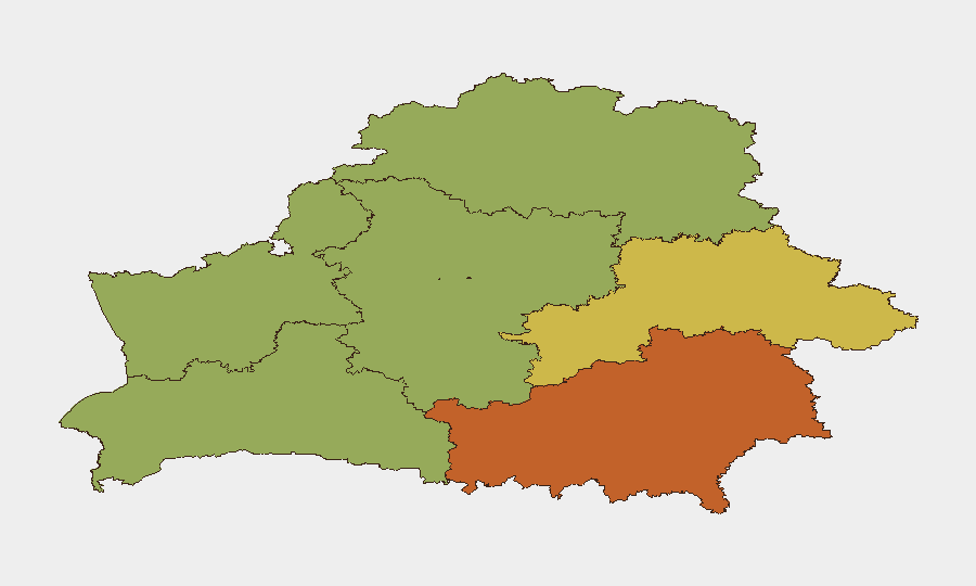
Homyel Region (risk 75) and Minsk (risk 68) are the primary drivers of the sub-national ranking. Homyel's elevated risk reflects its proximity to the Ukraine border and exposure to Russian air operations, as evidenced by the 22 August missile-drone incident in Gomel Region. Minsk's score reflects concentrated crime, transport-hub vulnerability (as shown in the armed robbery and escape attempt), and its role as the capital administrative hub. Mahilyow Region (risk 62) and Brest Region (risk 55) carry secondary risk from southern proximity to conflict zones and border-crossing activity. Storm damage and power outages are currently distributed nationally but concentrated in Grodno Region initially.
How GeoBit Would Assist
Security teams with people or assets in Belarus should employ AOI Monitoring & Early Warning to track cross-border air activity and military movements in Homyel and Gomel regions in real time. Conflict & Military tracking (battle mapping, force structure, weapons-capability assessment) would enable prediction of further Russian air incursions. Economic & Trade and Infrastructure mapping capabilities would support assessment of power-grid restoration timelines and supply-chain continuity, critical for businesses dependent on reliable electricity in affected settlements.
7-Day Outlook
Infrastructure restoration will progress through 25–31 August, with full power recovery expected within 5–7 days in most regions. Russian air incursions into Belarusian airspace are likely to recur during continued Ukraine operations, though Belarus' air defense response suggests containment. Crime and border-crossing pressures remain stable but should be monitored at transport hubs and frontier areas.
Highest-Risk Areas — Ranked
| # | State / Region | Risk |
|---|---|---|
| 1 | Homyel Region | 75 |
| 2 | Minsk | 68 |
| 3 | Mahilyow Region | 62 |
| 4 | Brest Region | 55 |
| 5 | Hrodna Region | 52 |
| 6 | Minsk Region | 48 |
| 7 | Vitsebsk Region | 45 |
Sources
Previous Daily Briefs
A new Belarus brief is written every day — each with its own risk map and downloadable CSV. Here's the last week; use the calendar to go further back.
- August 22, 2026
- August 20, 2026
- August 18, 2026
- August 15, 2026
- August 13, 2026
- August 11, 2026
- August 10, 2026
📅 Browse every day by calendar →
Highlighted days have a brief. Tap a day for that day's map & analysis, or “csv” for that day's dataset ($5).
Atlas — our AI intelligence desk — emails them this snapshot personally. Nothing else, no list.