Situation Summary
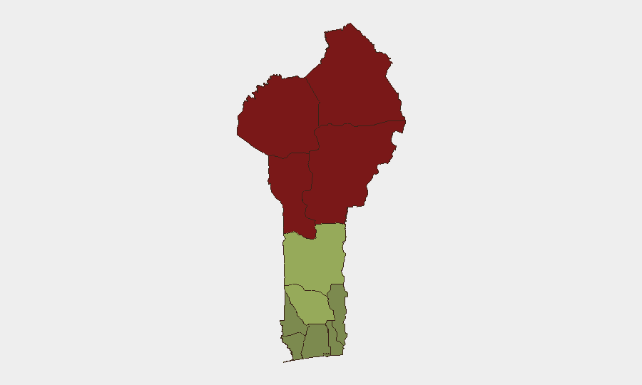
Benin's overall security posture remains moderate (global rank #null, composite threat score 17), but four tracked events in the last 72 hours reveal active tensions spanning Franco-Beninese relations, border stability with Niger, and domestic law-enforcement operations. Northern departments—particularly Alibori, Atakora, Donga, and Borgou—face significantly elevated risk (scores 83–92), driven by cross-border pressures and regional instability. Southern coastal zones show comparatively lower risk but remain subject to heightened counternarcotics and maritime enforcement activity as of late July 2026.
Key Developments
- Godomey, Abomey-Calavi (26–27 July 2026). Major anti-drug police operation resulted in arrest of 52 suspected traffickers and users, signaling intensified domestic counternarcotics enforcement in southern urban zones and likely increased police presence in and around Cotonou.
- Cotonou, maritime domain (24 July 2026, ongoing impact). European Union transferred high-speed interceptor vessel to Beninese Navy to enhance Gulf of Guinea patrols, anti-piracy operations, and illegal-fishing interdiction, creating heightened maritime enforcement risk in Beninese territorial waters.
- Benin–Niger border (26 July 2026). Niger's President Tiani stated that "wounds" between Niger and Benin remain unhealed and must be resolved before border reopening; border has remained closed since 2023 over allegations of Beninese–French alignment. Statement reaffirms sustained cross-border restrictions and reduced bilateral trade/movement across northern Benin.
- Franco-Beninese diplomatic tensions (26–27 July 2026). Event signals include mutual public statements and rejections between Benin and France/French entities, reflecting ongoing diplomatic friction likely tied to regional geopolitical realignment in West Africa.
- Public statements involving national and regional actors (25–27 July 2026). Statements from BENIN vs. GOVERNOR, PRESIDENT vs. BENIN, and NIGERIA vs. BENIN indicate internal and cross-border political messaging; context suggests coordination with or statements about regional security cooperation.
Highest-Risk Areas
Northern Benin—specifically Alibori, Atakora, Donga, and Borgou departments—account for the four highest risk scores (83–92) and dominate the threat landscape. These regions share porous borders with Niger and Burkina Faso, where jihadist networks, arms trafficking, and irregular migration create persistent destabilization. The 2023 Niger–Benin border closure has intensified economic strain and cross-border tension in these departments. Southern coastal departments (Atlantique, Littoral, Ouémé) show substantially lower risk (22–28) but face concentrated law-enforcement activity and maritime interdiction operations, particularly around Cotonou and Godomey.
How GeoBit Would Assist
Security and duty-of-care teams operating in Benin should employ AOI Monitoring & Early Warning on northern border zones (Alibori, Atakora) to detect cross-border movement, trafficking, or militant activity; Maritime & Aviation Tracking to monitor EU-supplied interceptor patrols and flag vessels of concern in Gulf of Guinea waters; and Network & Actor Analysis to map Franco-Beninese diplomatic fractures and regional actor positioning. OSINT fusion & corroboration (X/Twitter, Telegram, local media) would clarify the political statements and rejections flagged on 26–27 July and assess whether they signal escalating tension or tactical repositioning.
7-Day Outlook
Northern departments will likely remain under elevated alert as Niger–Benin border tensions persist and cross-border flows continue unmonitored. Domestic counternarcotics operations may expand regionally, creating operational disruptions in urban and transit corridors. Franco-Beninese diplomatic messaging will probably remain tense but is unlikely to trigger direct security incidents; however, regional realignment pressures may drive further border closures or trade restrictions affecting northern supply chains.
Highest-Risk Areas — Ranked
| # | State / Region | Risk |
|---|---|---|
| 1 | Alibori Department | 92 |
| 2 | Atakora Department | 88 |
| 3 | Donga Department | 85 |
| 4 | Borgou Department | 83 |
| 5 | Zou Department | 45 |
| 6 | Collines Department | 42 |
| 7 | Plateau Department | 38 |
| 8 | Kouffo Department | 35 |
| 9 | Mono Department | 32 |
| 10 | Atlantique Department | 28 |
| 11 | Littoral | 25 |
| 12 | Ouémé Department | 22 |
Sources
Previous Daily Briefs
A new Benin brief is written every day — each with its own risk map and downloadable CSV. Here's the last week; use the calendar to go further back.
📅 Browse every day by calendar →
Highlighted days have a brief. Tap a day for that day's map & analysis, or “csv” for that day's dataset ($5).
Atlas — our AI intelligence desk — emails them this snapshot personally. Nothing else, no list.