Situation Summary
Botswana remains a low-threat environment with a global composite threat ranking of #162 and no confirmed security incidents in the last 24–48 hours. The country maintains baseline stability across governance, infrastructure, and civil order. Urban centers—particularly Gaborone, South-East District, and Lobatse—carry elevated but manageable risk profiles, primarily driven by property crime and localized public-order concerns rather than organized violence or political instability. The security trajectory is stable with no indicators of near-term deterioration.
Key Developments
No independently verified security, conflict, civil-unrest, crime, political-instability, or travel-risk incidents were confirmed in Botswana during the 24–48-hour window (2026-08-11 to 2026-08-12). Routine baseline conditions persist across all monitored regions. No travel advisory changes, road disruptions, or police notices were issued in the current reporting period. Social-media and open-source intelligence sources contain no corroborated incident reports with explicit timestamps in the last two days.
Highest-Risk Areas
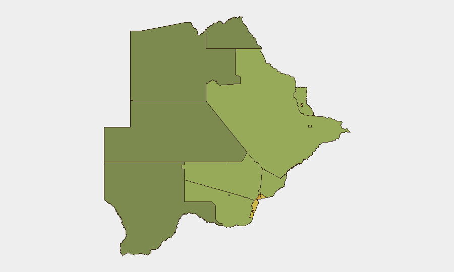
Gaborone (risk score 72) and South-East District (68) dominate the sub-national threat landscape, reflecting high urban-crime concentration, economic disparities, and property-theft prevalence in and around the capital. Lobatse (65) and Francistown (62) follow, with secondary hotspots in mining-sector towns—Jwaneng (61) and Selebi Phikwe (58)—where transient populations and cash-intensive economies create localized theft and assault risk. Northern and central rural districts (North-West, Central, North-East) score significantly lower, indicating crime risk correlates directly with urbanization and commercial activity. Organizations with assets or personnel in Gaborone and South-East District should prioritize standard urban-security protocols (transport vetting, residential hardening, after-hours movement restrictions).
How GeoBit Would Assist
A corporate security team operating in Botswana would deploy AOI Monitoring & Early Warning on high-risk urban zones (Gaborone, Lobatse, Francistown) to detect emerging crime patterns or civil-order degradation in real time. Multi-language OSINT fusion—combining local news, social-media sentiment analysis, and police-notice scanning—would provide early signals of roadblock activity, demonstrations, or curfews before they affect supply chains or personnel movement. Routing & Network Analysis would generate real-time alternative transport corridors and safe-zone mapping for duty-of-care compliance, particularly for staff commuting in high-risk districts.
7-Day Outlook
No escalatory triggers are visible in the current intelligence window. Botswana's political calendar, economic indicators, and security-force activity show no signs of acute risk expansion over the next seven days. Standard precautions in urban centers remain appropriate; no advisory upgrade or temporary movement restrictions are warranted at this time.
Report Date: 2026-08-12 | Confidence Level: High (no current incidents; baseline assessment reliable) | Next Update: 2026-08-13
Highest-Risk Areas — Ranked
| # | State / Region | Risk |
|---|---|---|
| 1 | Gaborone | 72 |
| 2 | South-East District | 68 |
| 3 | Lobatse | 65 |
| 4 | Francistown | 62 |
| 5 | Jwaneng | 61 |
| 6 | Selebi Phikwe | 58 |
| 7 | Southern District | 55 |
| 8 | Kgatleng District | 50 |
| 9 | Kweneng District | 48 |
| 10 | North-East District | 45 |
| 11 | Central District | 42 |
| 12 | North-West District | 38 |
Sources
Previous Daily Briefs
A new Botswana brief is written every day — each with its own risk map and downloadable CSV. Here's the last week; use the calendar to go further back.
📅 Browse every day by calendar →
Highlighted days have a brief. Tap a day for that day's map & analysis, or “csv” for that day's dataset ($5).
Atlas — our AI intelligence desk — emails them this snapshot personally. Nothing else, no list.