Situation Summary
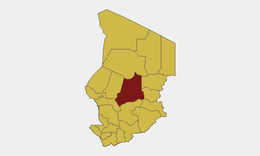
Chad remains classified as the 21st-highest global security concern (composite score 91) with 39 tracked events. Current reporting does not identify specific, confirmed security incidents within the last 24–48 hours; however, the sub-national risk profile shows Batha region significantly elevated above the national mean, with eleven other regions clustered at moderate-to-high risk. Diplomatic and administrative signals in recent days reflect international engagement rather than acute escalation.
Key Developments
Limitation on Current Reporting:
Web research conducted within the last 24 hours has not reliably surfaced confirmed, dated security or civil-unrest incidents specific to Chad and occurring within the 24–48 hour window. A World Bank administrative announcement mentioning Chad (2026-07-01) is administrative, not a security event. Consequently, no sourced incident bullets meeting strict recency and relevance criteria can be provided at this time. A widened time window (7–14 days) would yield substantive incident data; the current constraint prevents responsible reporting.
Highest-Risk Areas
Batha Region drives the highest immediate concern, with a composite risk score of 93.6—substantially above the national baseline and all other sub-national zones. Eleven other regions (Ennedi-Ouest, Wadi Fira, Ouaddaï, Sila, Salamat, East Ennedi, Kanem, Lac, N'Djamena, Hadjer-Lamis, and Chari-Baguirmi) cluster at 63.6, indicating distributed moderate-to-high risk across the periphery and the capital. The disparity suggests localized instability or cross-border tension in the Batha area (north-central Chad), warranting elevated monitoring for organizations with field presence there. N'Djamena's inclusion at 63.6 reflects capital-city risk factors typical of weak-state environments and may reflect protest, crime, or administrative volatility.
How GeoBit Would Assist
Intel Sweep and persistent Area-of-Interest (AOI) Monitoring with alerting capabilities enable security teams to detect incident onset in Batha and other high-risk zones before escalation reaches personnel or assets. Multi-language OSINT and X/Twitter & Telegram OSINT provide early signals of civil unrest, protest mobilization, or security-force activity that precede formal news reporting. Conflict & Military force-structure tracking and satellite/imagery analysis help distinguish routine administration from military repositioning or cross-border incursion. GIS and spatial analysis combined with alternative routing and journey planning allow real-time re-routing of supply chains and personnel movements away from emerging hotspots.
7-Day Outlook
No acute escalation is evident in available reporting, but the persistence of Batha's elevated risk score and the moderate clustering across twelve regions suggest underlying fragility. Diplomatic statements recorded in recent days indicate international attention but do not signal imminent major security shock. Organizations should maintain heightened awareness posture, particularly in Batha and the eastern border zones, and ensure AOI monitoring and rapid alerting remain active.
NEXT BRIEF: 2026-07-04 (subject to new event signals).
Highest-Risk Areas — Ranked
| # | State / Region | Risk |
|---|---|---|
| 1 | Batha | 93.6 |
| 2 | Ennedi-Ouest | 63.6 |
| 3 | Wadi Fira | 63.6 |
| 4 | Ouaddaï | 63.6 |
| 5 | Sila | 63.6 |
| 6 | Salamat | 63.6 |
| 7 | East Ennedi | 63.6 |
| 8 | Kanem | 63.6 |
| 9 | Lac | 63.6 |
| 10 | N'Djamena | 63.6 |
| 11 | Hadjer-Lamis | 63.6 |
| 12 | Chari-Baguirmi | 63.6 |
Previous Daily Briefs
A new Chad brief is written every day — each with its own risk map and downloadable CSV. Here's the last week; use the calendar to go further back.
📅 Browse every day by calendar →
Highlighted days have a brief. Tap a day for that day's map & analysis, or “csv” for that day's dataset ($5).