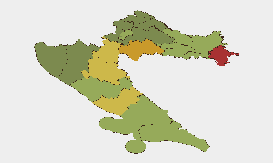
Situation Summary
Croatia remains at low national security risk (composite score 6; no tracked discrete events) with no verified reports of terrorism, civil unrest, or major infrastructure disruption in the last 24–48 hours. However, sub-national risk concentrates in the eastern and southeastern border regions (Vukovar-Srijem, Sisak-Moslavina, and Karlovac counties), where composite scores exceed 65–78, reflecting legacy conflict exposure and ongoing arms-circulation concerns. Current developments are localized—routine crime, traffic incidents, and temporary military activity—indicating stable conditions overall with manageable seasonal and regional variations.
Key Developments
- Đakovo (Osijek-Baranja County) – 26–27 Jul 2026: Police charged a 53-year-old resident after search operations recovered a significant cache of illegal firearms, hand grenades, and ammunition. No active incident or use reported, but the seizure underscores underlying weapons-circulation risk in eastern regions.
- Pag Island (Zadar County) – 27 Jul 2026: A knife assault during nightlife hours resulted in injury to a young man; police detained a male acquaintance as suspect. Investigation ongoing; typical seasonal localized violence with no broader implications.
- Crikvenica–Dramalj (Primorje-Gorski Kotar County) – 27 Jul 2026: German national arrested on three European arrest warrants for serious theft and fraud. Law-enforcement activity in a coastal tourist zone; no wider threat indication.
- Istria County – 26–27 Jul 2026: German citizen (66) charged with child-exploitation offenses. Serious crime but no public-order impact; relevant to family-safety due diligence.
- Road network (Istria) – weekend through 26 Jul: Extended-weekend traffic enforcement recorded 22 accidents, 1 fatality, 18 injuries, and 328 violations over three days. Elevated accident rates in high-season travel corridors.
- Central Adriatic (Žirje Island area) – ongoing from 27 Jul: Croatian military exercises ("Borbena moć 26") active in coming days; maritime advisory urges yacht/charter operators to check Notices to Mariners and respect exclusion zones.
- Karigador (near Novigrad, Istria) – night of 26–27 Jul: Structure fire (sofa ignition, partial building damage) with no reported casualties; cause not yet determined.
- Non-EU worker health screening (national) – announced last 24–48 h: New mandatory health-screening policy for non-EU employees effective. Administrative change affecting foreign-worker processing; no direct travel or public-safety impact.
Highest-Risk Areas
Eastern and southeastern border counties dominate sub-national rankings, with Vukovar-Srijem (78), Sisak-Moslavina (72), and Karlovac (68) reflecting post-conflict demography, dispersed small-arms availability, and lower economic development indices. These regions warrant enhanced due-diligence for personnel and asset exposure. Western and coastal counties (Zagreb city, Split-Dalmatia, Zadar) carry moderate risk (48–55) driven by seasonal tourism congestion, petty crime, and routine traffic incidents rather than structural instability. The risk differential reflects geography and legacy fragmentation rather than active conflict.
How GeoBit Would Assist
Security teams operating in Croatia should employ AOI Monitoring & Early Warning to track Vukovar-Srijem, Sisak-Moslavina, and Karlovac counties for arms-trafficking, trafficking-in-persons, and cross-border anomalies. Conflict & Military capability combined with Maritime & Aviation tracking would enable real-time awareness of military exercises and their impact on supply-chain routing and marine operations. Crime and weapons-focused search combined with sentiment and temporal analysis of local social feeds and police bulletins ensures rapid detection of localized violence spikes affecting personnel safety.
7-Day Outlook
No major escalation is forecast in the near term. Military exercises around Žirje will conclude within days, after which maritime traffic normalizes. Seasonal accidents and petty crime will persist at current elevated levels through peak summer tourism; enforcement activity will remain visible but routine. Regional arms-circulation awareness should remain elevated, particularly in eastern counties.
Highest-Risk Areas — Ranked
| # | State / Region | Risk |
|---|---|---|
| 1 | Vukovar-Srijem County | 78 |
| 2 | Sisak-Moslavina County | 72 |
| 3 | Karlovac County | 68 |
| 4 | Lika-Senj County | 65 |
| 5 | Šibenik-Knin County | 62 |
| 6 | Brod-Posavina County | 58 |
| 7 | Zadar County | 55 |
| 8 | Osijek-Baranja County | 52 |
| 9 | City of Zagreb | 50 |
| 10 | Split-Dalmatia County | 48 |
| 11 | Požega-Slavonia County | 45 |
| 12 | Virovitica-Podravina County | 42 |
Sources
Previous Daily Briefs
A new Croatia brief is written every day — each with its own risk map and downloadable CSV. Here's the last week; use the calendar to go further back.
📅 Browse every day by calendar →
Highlighted days have a brief. Tap a day for that day's map & analysis, or “csv” for that day's dataset ($5).
Atlas — our AI intelligence desk — emails them this snapshot personally. Nothing else, no list.