Situation Summary
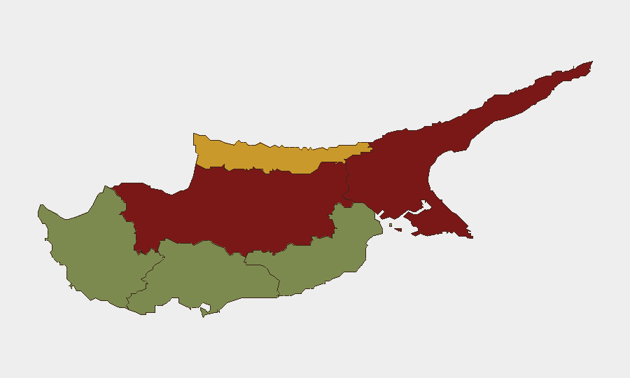
Cyprus remains a low-threat environment globally (rank #169; composite score 5) with no discrete security events in the current tracking window. However, police activity over 24–25 August reveals sustained enforcement operations across the island, including arrests for vehicle theft, drug possession, and assault, along with ongoing investigations into organized street violence targeting service workers. The sub-national threat picture is heavily concentrated in the Nicosia and Famagusta districts (risk scores 92 and 88 respectively), while southern coastal zones (Limassol, Paphos, Larnaca) present substantially lower risk. Overall trajectory remains stable, with crime-prevention operations indicating normal policing posture rather than emerging crisis.
Key Developments
- Nationwide police operations (24–25 August, overnight): Police conducted intensive crime-prevention operations across urban areas, roads, and premises, checking 446 drivers and 131 passengers, inspecting 38 premises, and making six arrests for vehicle theft, illegal residence, drug possession, and assault on police. Traffic enforcement yielded 246 citations, including 68 speeding cases, one positive alcohol test, and three drug-driving cases; eight vehicles were seized.
- Paphos delivery-driver attack arrests (25 August, ~14:30): Police arrested an 18-year-old as the fourth suspect in a series of group attacks on delivery drivers that occurred in Paphos the previous week. The suspect faces charges including conspiracy, robbery, assault, rioting, and illegal possession of offensive weapons; three other suspects remain in custody.
- Aradippou Industrial Zone fire (25 August): A fire was reported in the Aradippou Industrial Area (Larnaca district) and subsequently extinguished with no reported entrapment. Local air quality and movement may have been temporarily affected; the hazard has been contained.
- Sovereign Base Areas enforcement (week ending 25 August): British SBA police reported 34 arrests over one week, including eight for drink/drug driving. This underscores sustained enforcement on roads used by residents and visitors, with impaired driving a documented safety concern.
- Famagusta tourist fatality (25 August, autopsy confirmed): A German tourist found unconscious in a hotel swimming pool in Famagusta district was confirmed by autopsy to have died by drowning; toxicology results pending. This is an accidental incident with travel-safety relevance.
Highest-Risk Areas
Nicosia (risk 92) and Famagusta (risk 88) together account for the overwhelming majority of sub-national threat concentration, reflecting these districts' role as administrative and contested-zone proximity areas respectively. Kyrenia (risk 72) represents a secondary concern. In contrast, Limassol (22), Larnaca (28), and Paphos (18) present substantially lower individual risk scores, though Paphos has been the site of recent organized street violence against service workers. The north–south geographical divide in threat scoring likely reflects security apparatus density, cross-line movement friction, and urban crime prevalence in divided Nicosia.
How GeoBit Would Assist
Security teams with personnel or assets in Cyprus should employ AOI Monitoring & Early Warning on high-risk districts (Nicosia, Famagusta) to detect emerging organized crime or political unrest in near-real time. Routing & Network Analysis capabilities enable duty-of-care teams to plan delivery and service-worker movements away from documented attack zones (e.g., Paphos) and identify safe transit corridors. Intel Sweep and multi-language OSINT fusion provide continuous low-level intelligence on police operations, street crime, and industrial hazards to populate situational awareness dashboards for on-island teams.
7-Day Outlook
No major security escalation is expected in the near term. Police operations are routine and focused; organized crime (delivery-driver attacks) is localized and actively investigated. Continued elevated police presence in urban areas and along main roads should be anticipated, with potential minor traffic delays from enforcement checks. Teams should maintain standard duty-of-care protocols and monitor local news for any unplanned incident clusters in Nicosia or Famagusta.
Highest-Risk Areas — Ranked
| # | State / Region | Risk |
|---|---|---|
| 1 | Nicosia | 92 |
| 2 | Famagusta | 88 |
| 3 | Kyrenia | 72 |
| 4 | Larnaca | 28 |
| 5 | Limassol | 22 |
| 6 | Paphos | 18 |
Sources
Previous Daily Briefs
A new Cyprus brief is written every day — each with its own risk map and downloadable CSV. Here's the last week; use the calendar to go further back.
- August 23, 2026
- August 20, 2026
- August 18, 2026
- August 16, 2026
- August 14, 2026
- August 12, 2026
- August 10, 2026
📅 Browse every day by calendar →
Highlighted days have a brief. Tap a day for that day's map & analysis, or “csv” for that day's dataset ($5).
Atlas — our AI intelligence desk — emails them this snapshot personally. Nothing else, no list.