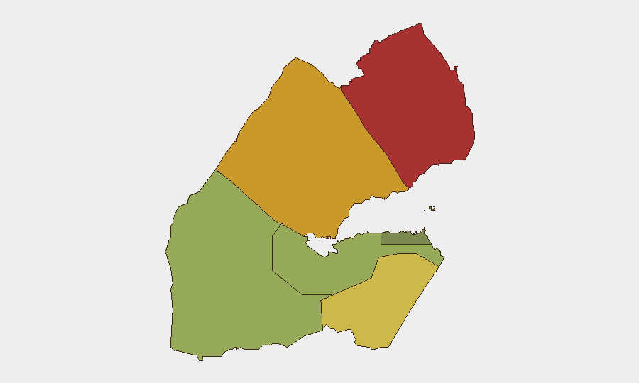
Situation Summary
Djibouti remains a relatively stable transit and strategic hub in the Horn of Africa (global ranking #86), but faces localized security pressures in its northern border regions. Two incidents in the past 72 hours—a U.S. MQ-9 drone crash near Chabelley Airbase on 9 August and a naval engagement with a suspected Yemeni vessel on 8 August—underscore persistent maritime and airspace vulnerabilities. The broader threat environment is driven by proximity to Yemen's instability and cross-border incursions rather than domestic political instability.
Key Developments
- Chabelley Airbase vicinity, Djibouti City — 9 Aug 2026: U.S. Embassy issued an urgent security alert regarding an aircraft in distress in Djiboutian airspace; OSINT and regional sources subsequently confirmed a U.S. MQ-9 drone crash near the airbase, prompting airspace restrictions and civilian evacuation advisories.
- Djiboutian territorial waters, off-coast — 8 Aug 2026: Djibouti Defence Ministry reported two soldiers sustained wounds during a naval patrol engagement with a suspected Yemeni vessel that allegedly opened fire; Djiboutian forces returned fire during the interception and pursuit.
- Obock Region context (72+ hours prior): The 8 August naval clash occurred within Obock Region, Djibouti's highest-risk sub-national zone, reflecting sustained cross-border maritime activity and weapons presence.
Highest-Risk Areas
Obock Region (risk score 78) and Tadjourah Region (score 72) dominate the threat landscape, driven by proximity to Yemen and a permeable maritime border where suspected arms smuggling, piracy, and naval incursions have occurred. Ali Sabieh (score 65) follows as a secondary concern along the inland border. Djibouti City and surrounding Djibouti Region (score 35) remain substantially lower-risk, though the drone incident on 9 August demonstrates that even the capital vicinity is not immune to spillover events. Risk concentration in the north reflects Yemen's ongoing instability and the difficulty of enforcing maritime sovereignty in the Gulf of Aden approaches.
How GeoBit Would Assist
Teams with personnel or assets in Djibouti should employ Maritime & Aviation tracking to monitor cross-border vessel activity and airspace incursions in real time, supplemented by AOI Monitoring & Early Warning focused on Obock and Tadjourah ports and coastal entry points. OSINT Fusion & Corroboration (X/Twitter, Arabic/French local sources, OSINT video analysis) can provide rapid confirmation of incidents like the drone crash before official channels, reducing response lag. GIS & Spatial Analysis and Satellite & Imagery analysis enable ongoing assessment of military buildup, vessel staging areas, and infrastructure damage near ports and airbases.
7-Day Outlook
No major escalation is anticipated in the near term; both the drone crash and naval engagement appear to be isolated incidents rather than indicators of a coordinated campaign. However, sustained Yemeni maritime activity and weapons proliferation mean incidents of this nature will likely recur. Organizations should expect continued U.S. and allied military operations in and around Djibouti, with occasional airspace or port disruptions.
Highest-Risk Areas — Ranked
| # | State / Region | Risk |
|---|---|---|
| 1 | Obock | 78 |
| 2 | Tadjourah | 72 |
| 3 | Ali Sabieh | 65 |
| 4 | Arta | 48 |
| 5 | Dikhil | 42 |
| 6 | Djibouti | 35 |
Sources
Previous Daily Briefs
A new Djibouti brief is written every day — each with its own risk map and downloadable CSV. Here's the last week; use the calendar to go further back.
📅 Browse every day by calendar →
Highlighted days have a brief. Tap a day for that day's map & analysis, or “csv” for that day's dataset ($5).
Atlas — our AI intelligence desk — emails them this snapshot personally. Nothing else, no list.