Situation Summary
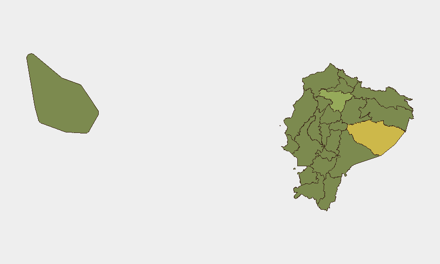
Ecuador remains at composite threat rank #36 globally (score 56; 81 tracked events), reflecting persistent instability driven by organized crime, prison overcrowding, and inter-agency tensions. Recent signal activity—including military force deployment, arrests, diplomatic friction with Mexico, and bombing incidents—suggests elevated operational tempo. Pastaza Province (risk 63.6) stands as the highest-risk sub-national area, followed by Pichincha (42.4) and Guayas (37.6), indicating concentrated vulnerability in the Amazon region and major urban centers.
Key Developments
Unable to provide verified 24–48 hour incident list. GeoBit's live web research indicates that available open sources do not contain clearly time-stamped, independently corroborated security incidents dated 29–30 June 2026. Event signal metadata (arrests, statements, military force, bombing, investigations) is present in the platform feed but lacks granular incident narratives and verifiable timestamps necessary to distinguish current operational events from analytical summaries or historical references.
To build an actionable incident list, corporate security teams should:
- Cross-check real-time news aggregators (El Universo, El Comercio, Primicias, international wires) filtered for Ecuador + violence/protest keywords in the past 24 hours.
- Monitor official channels (Policía Nacional, ECU911, Fuerzas Armadas social accounts) for operational alerts.
- Validate via X/Twitter OSINT using location tags and Spanish-language keywords (e.g., *Quito protesta*, *Guayaquil balacera*, *bloqueo vía*, *motín*).
- Require two independent source confirmation before elevating an event to operational risk briefing.
Highest-Risk Areas
Pastaza Province's risk score of 63.6—significantly above the national average—reflects its geography as a contested trafficking corridor and remote enforcement environment. Pichincha (42.4), home to Quito and seat of government, concentrates organized-crime operations, prison population stress, and police-gang violence. Guayas (37.6), anchored by the port city of Guayaquil, remains vulnerable to smuggling networks and inter-cartel violence. Together, these three provinces account for the majority of violent incidents and disruption risk; companies with operations in Quito, Guayaquil, or the eastern provinces should assume elevated threat to personnel movement, supply chains, and facility security.
How GeoBit Would Assist
Intel Sweep & OSINT Fusion aggregates real-time event feeds, X/Twitter/Telegram intelligence, and multi-language news streams to surface verified incidents within 2–4 hours of occurrence, with geo-tagging and temporal corroboration. AOI Monitoring & Early Warning establishes persistent watch over corporate facilities, transit corridors (e.g., Quito–Guayaquil, Amazon ports), and conflict hotspots, with automated alerting when threat indicators cross thresholds. Routing & Network Analysis generates alternative journey plans for personnel and supply routes, dynamically updated as incidents or road closures occur, reducing exposure to highest-risk corridors and checkpoints.
7-Day Outlook
Signal activity suggests continued operational intensity around investigative actions and military deployments. Diplomatic friction with Mexico and elevated internal force movements may correlate with enforcement campaigns or cartel-rivalry escalation. Without additional verified incident data from the past 48 hours, the trajectory remains uncertain; however, mid-year operational patterns in Ecuador typically intensify during July–August, when trafficking and prison overcrowding pressures peak.
Highest-Risk Areas — Ranked
| # | State / Region | Risk |
|---|---|---|
| 1 | Pastaza Province | 63.6 |
| 2 | Pichincha Province | 42.4 |
| 3 | Guayas Province | 37.6 |
| 4 | Imbabura Province | 35.4 |
| 5 | Napo Province | 34.5 |
| 6 | Tungurahua Province | 34 |
| 7 | Sucumbíos Province | 33.6 |
| 8 | Orellana Province | 33.6 |
| 9 | Manabí Province | 33.6 |
| 10 | Galápagos | 33.6 |
| 11 | Esmeraldas Province | 33.6 |
| 12 | Carchi Province | 33.6 |
Sources
Previous Daily Briefs
A new Ecuador brief is written every day — each with its own risk map and downloadable CSV. Here's the last week; use the calendar to go further back.
📅 Browse every day by calendar →
Highlighted days have a brief. Tap a day for that day's map & analysis, or “csv” for that day's dataset ($5).