Situation Summary
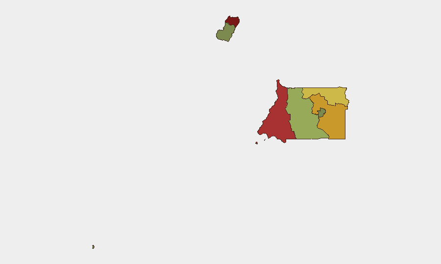
Equatorial Guinea remains a low-frequency threat environment globally (rank #157), with no discrete security incidents recorded in the current 24–48-hour window. The country's composite threat score of 5 reflects endemic governance and institutional fragility rather than active conflict or organized violence. Security posture across provinces remains stratified, with significant concentration of risk in the northern and coastal zones. The absence of recent event signals suggests operational stability, but structural vulnerabilities in border areas and resource-extraction zones warrant continued monitoring.
Key Developments
No verified discrete security events have been reported in Equatorial Guinea during the last 24–48 hours. Current web research does not surface recent, dated incidents requiring immediate briefing action. Duty-of-care teams should note this as a data gap rather than an all-clear; low event reporting volume in Equatorial Guinea is typical and does not indicate comprehensive coverage or absence of underlying risk.
Highest-Risk Areas
Bioko Norte (risk 85) and Litoral Province (risk 78) dominate the national risk profile and warrant priority attention. Both zones combine limited state capacity, porous borders, and significant informal-economy activity—creating vulnerabilities to transnational crime, human trafficking, and currency/resource diversion. Wele-Nzas Province (72) and Kié-Ntem (68) in the mainland interior present elevated cross-border risk, particularly along the Cameroon and Gabon frontiers, where smuggling networks and border-enforcement gaps are persistent. Centro Sur (45) and southern Bioko (38) show lower incident density but remain active duty-of-care zones for extractive and energy-sector personnel.
How GeoBit Would Assist
Security teams operating in Equatorial Guinea should employ AOI Monitoring & Early Warning on Bioko Norte and Litoral Province to detect emerging protest activity, labor unrest, or trafficking indicators before operational impact. Network & Actor Analysis and multi-language OSINT (via Intel Sweep and X/Telegram monitoring) will track informal governance actors, criminal nodes, and regime-stability signals across provincial capitals. Routing & Network Analysis supports alternative-route planning for personnel and asset movement, particularly in border provinces; satellite and GIS analysis enables persistent visibility of border-crossing points, informal settlements, and resource-extraction sites where duty-of-care incidents historically concentrate.
7-Day Outlook
No imminent destabilizing events are signaled for the coming week. Monitoring should remain focused on labor and civil-service tensions, which historically spike around fiscal events or wage delays. Border zones should be treated as persistent-watch areas given smuggling seasonality and informal-economy volatility; any disruption to energy or port operations would warrant rapid escalation and scenario planning for personnel mobility.
Next Steps: Refresh OSINT sweep in 48 hours. Flag any developments in Bioko Norte or Litoral Province for same-day escalation. Request historical incident database for Equatorial Guinea to establish baseline for anomaly detection.
Highest-Risk Areas — Ranked
| # | State / Region | Risk |
|---|---|---|
| 1 | Bioko Norte | 85 |
| 2 | Litoral Province | 78 |
| 3 | Wele-Nzas Province | 72 |
| 4 | Kié-Ntem Province | 68 |
| 5 | Centro Sur Province | 45 |
| 6 | Bioko Sur | 38 |
| 7 | Djibloho | 15 |
| 8 | Annobón Province | 8 |
Sources
Previous Daily Briefs
A new Equatorial Guinea brief is written every day — each with its own risk map and downloadable CSV. Here's the last week; use the calendar to go further back.
- August 12, 2026
- August 10, 2026
- August 8, 2026
- August 6, 2026
- August 5, 2026
- August 4, 2026
- August 3, 2026
📅 Browse every day by calendar →
Highlighted days have a brief. Tap a day for that day's map & analysis, or “csv” for that day's dataset ($5).
Atlas — our AI intelligence desk — emails them this snapshot personally. Nothing else, no list.