Situation Summary
Fiji remains a low-threat environment globally (rank #65, composite score 28) with no tracked acute security crises as of 21 August 2026. Recent activity reflects routine crime pressure—burglaries, theft, and drug offenses—alongside natural hazards (a 5.5-magnitude earthquake on 19 August and a fatal fire in Tavua on 14 August). Government agencies are actively advancing border security, maritime surveillance, and cybersecurity infrastructure, indicating a baseline operational posture rather than response to imminent threat.
Key Developments
- Nadi International Airport (15 Aug, ongoing): Fiji Revenue and Customs Service and Australian Border Force jointly inaugurated enhanced CCTV and multi-purpose security facilities, strengthening border screening and detection capability.
- Nationwide maritime operations (18–20 Aug): Fiji authorities intensified enforcement across its EEZ against illegal fishing using satellite imagery, vessel monitoring, sea and aerial patrols, and port inspections; concurrent cooperation with a US cutter focused on drug trafficking and transnational maritime crime.
- Suva / national digital infrastructure (20 Aug): Government announced advancement of digital identity and cybersecurity initiatives, including a National Identification Initiative, national digital strategy, and a 24/7 Network and Security Operations Center.
- Nationwide crime trends (18–20 Aug reporting): Police data and advisory activity highlighted ongoing house break-ins; ODPP July crime statistics indicated theft, burglary, drug possession, aggravated robbery, and grievous harm as primary serious charges, reflecting sustained rather than escalating pressure.
- Samabula, Suva (17 Aug): Police investigated an alleged sacrilege incident; separate 17 August armed robbery investigation occurred on Howell Road in Samabula involving a residential break-in and cash theft.
- National deportation (17 Aug): A US-based Ponzi scheme suspect was deported from Fiji to face prosecution in the United States.
- Natural hazards (19 Aug): A 5.5-magnitude earthquake struck the Fiji Islands Region; no major damage or displacement reported.
Highest-Risk Areas
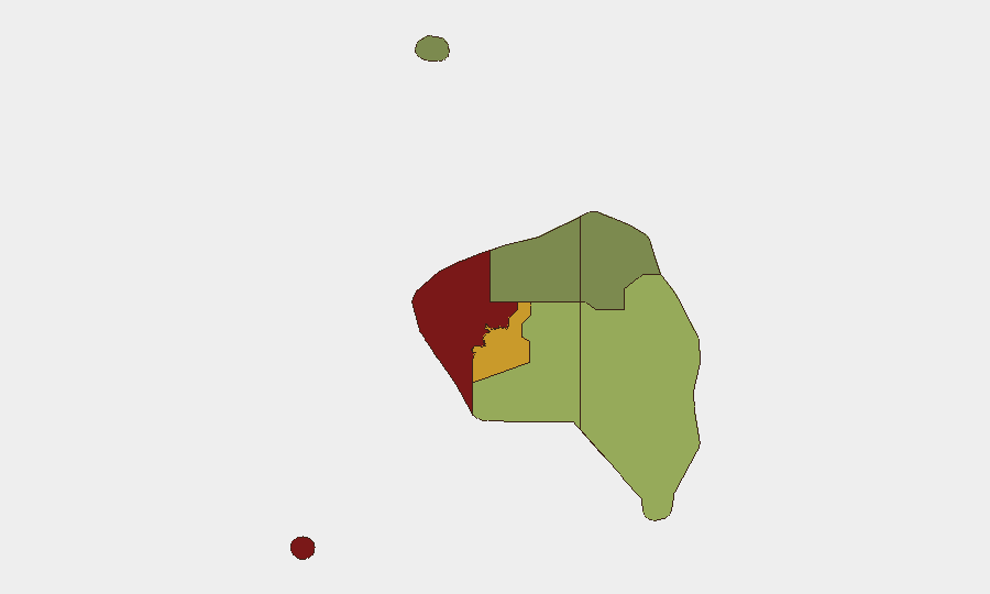
Western Division (risk 85) and Central Division (risk 72) drive the national risk profile, substantially exceeding Eastern (45), Northern (38), and Rotuma (12). The Western region's elevated score reflects crime density, infrastructure vulnerability, and historical incident clustering in urban centers such as Tavua and Lautoka; Central Division risk is anchored in Suva's population density and prevalence of property crime and burglary. Eastern and Northern divisions show moderate residual risk tied to transport incidents and maritime vulnerability. Rotuma remains lowest-risk, reflecting isolation and lower population concentration.
How GeoBit Would Assist
Security teams with personnel or assets in Fiji should deploy AOI Monitoring & Early Warning on high-risk urban precincts (Suva, Lautoka, Nadi) to detect cluster shifts in burglary, robbery, or civil unrest before they impact operations. Maritime & Aviation Tracking combined with conflict and crime intelligence feeds provide real-time visibility on port activity, vessel movements, and transnational crime activity relevant to supply-chain or travel security. GIS & Spatial Analysis of incident hotspots by division and sub-region allows risk-proportionate staffing and movement planning, particularly in Western and Central divisions.
7-Day Outlook
No major escalation is anticipated in the near term. Routine crime, maritime enforcement, and infrastructure investment are likely to continue at current tempo. Natural hazard risk (seismic and cyclone seasonality) remains baseline for the region; organizations should maintain standard disaster-continuity protocols.
Highest-Risk Areas — Ranked
| # | State / Region | Risk |
|---|---|---|
| 1 | Western | 85 |
| 2 | Central | 72 |
| 3 | Eastern | 45 |
| 4 | Northern | 38 |
| 5 | Rotuma | 12 |
Sources
Previous Daily Briefs
A new Fiji brief is written every day — each with its own risk map and downloadable CSV. Here's the last week; use the calendar to go further back.
- August 20, 2026
- August 18, 2026
- August 17, 2026
- August 16, 2026
- August 15, 2026
- August 14, 2026
- August 13, 2026
📅 Browse every day by calendar →
Highlighted days have a brief. Tap a day for that day's map & analysis, or “csv” for that day's dataset ($5).
Atlas — our AI intelligence desk — emails them this snapshot personally. Nothing else, no list.