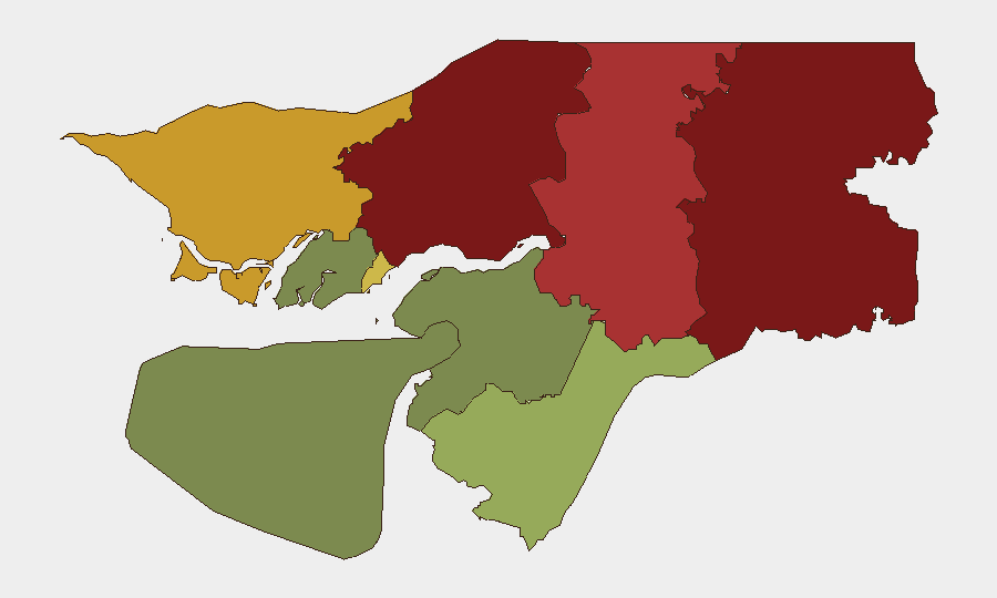
Situation Summary
Guinea-Bissau remains at composite threat level 8 (rank #135 globally) with no confirmed acute security incidents in the last 24–48 hours. The country continues to experience underlying political tension ahead of a scheduled 30 August referendum, and historical military-judicial friction persists in institutional channels. Regional risk remains concentrated in the northern and central border zones, where governance capacity and security force presence are weakest.
Key Developments
No discrete security or civil unrest incidents were independently confirmed in Guinea-Bissau during 19–20 August 2026. Available reporting from the last 24–48 hours does not surface armed clashes, major public disorder, or localized violence requiring immediate duty-of-care escalation. Political activity—campaign messaging and referendum logistics—continues in advance of the 30 August vote, but has not triggered observable street-level disruption or security force mobilization as of this window. Monitoring of social media and local news feeds (18–20 Aug) shows no evidence of coordinated unrest, blockades, or cross-regional incident clustering that would indicate emerging flashpoints.
Highest-Risk Areas
Gabu Region (risk 92), Oio Region (risk 85), and Bafatá Region (risk 78) drive the country's sub-national risk profile, reflecting historical gaps in state capacity, cross-border smuggling networks, and limited security-force density in Guinea-Bissau's northern and central interior. These zones have historically experienced trafficking, informal arms movement, and occasional communal disputes; absence of robust governance institutions amplifies friction resolution timelines. Bissau Autonomous Sector (risk 68) ranks fifth but merits attention as the capital and seat of political/military institutions where electoral tensions and factional dynamics carry widest consequence. Southern and eastern regions (Bolama, Quinara, Biombo) present substantially lower risk profiles.
How GeoBit Would Assist
Teams operating in or transiting Guinea-Bissau should employ AOI Monitoring & Early Warning on Gabu, Oio, and Bafatá regions to detect emerging unrest, security-force movement, or trafficking activity before operational impact; OSINT Fusion (X/Telegram/local media) to cross-confirm political developments and avoid reliance on single-source rumor; and Election Monitoring capabilities to track referendum-related incidents, inflammatory rhetoric, and potential post-vote flashpoints through 31 August and beyond. Routing & Network Analysis supports contingency planning for personnel movement in higher-risk northern zones.
7-Day Outlook
The 30 August referendum represents the primary near-term political event; absent major institutional breakdown or mass unrest in the coming week, current threat trajectory remains stable. Security teams should maintain baseline monitoring intensity through referendum day and the 48–72 hours following, when post-vote friction (if any) would most likely surface. No intelligence signals at present suggest imminent violence, but the historically fragile civil-military equilibrium and limited institutional transparency warrant continued passive watch on Bissau and northern border regions.
Highest-Risk Areas — Ranked
| # | State / Region | Risk |
|---|---|---|
| 1 | Gabu Region | 92 |
| 2 | Oio Region | 85 |
| 3 | Bafatá Region | 78 |
| 4 | Cacheu Region | 72 |
| 5 | Bissau Autonomous Sector | 68 |
| 6 | Tombali Region | 45 |
| 7 | Quinara Region | 38 |
| 8 | Biombo Region | 32 |
| 9 | Bolama Region | 15 |
Sources
Previous Daily Briefs
A new Guinea-Bissau brief is written every day — each with its own risk map and downloadable CSV. Here's the last week; use the calendar to go further back.
- August 17, 2026
- August 15, 2026
- August 13, 2026
- August 11, 2026
- August 10, 2026
- August 8, 2026
- August 6, 2026
📅 Browse every day by calendar →
Highlighted days have a brief. Tap a day for that day's map & analysis, or “csv” for that day's dataset ($5).
Atlas — our AI intelligence desk — emails them this snapshot personally. Nothing else, no list.