Situation Summary
Iran faces acute escalation risk as military, diplomatic, and cyber threats converge simultaneously. The central military command's announced closure of the Strait of Hormuz (June 23) stands in direct contradiction to parallel Omani–Iranian statements that the waterway will remain open, creating immediate uncertainty for maritime commerce and signalling fractured decision-making or deliberate ambiguity. Elevated US–Iran rhetoric, ongoing Israeli operations in southern Lebanon, cyberattacks on Iranian banks, and confirmed drone strikes against commercial shipping underscore a security environment that has transitioned from chronic tension to acute operational risk. Without rapid de-escalation or clearer enforcement of the US–Iran memorandum, further military action is probable within days.
Key Developments
- Strait of Hormuz (June 23): Iran's central military command announced closure of the strategic waterway in response to alleged US violations of a memorandum and ongoing Israeli strikes in southern Lebanon. Hours later, Omani and Iranian officials contradicted this, stating the Strait will remain open, creating severe uncertainty for shipping insurers and operators.
- Bürgenstock, Switzerland (June 23): Iran's chief negotiator publicly warned via social media that armed forces are "ready to respond" after President Trump threatened to take control of Iran and the Strait of Hormuz, elevating signalled military posture.
- Strait of Hormuz maritime corridor (June 22–23): US Central Command reported Iran launched multiple one-way attack drones against commercial vessels transiting the Strait, confirming direct hostile action against civilian shipping.
- Tehran (June 23): Iranian officials restated via state and social media that Lebanon ceasefire status and Hormuz access are integral to the US–Iran memorandum, framing further Israeli or perceived US non-compliance as potential triggers for additional Iranian military measures.
- Iranian banking sector, nationwide (June 22–23): Multiple Iranian banks suffered cyberattacks days after President Trump announced frozen Iranian funds would be returned, raising concerns about financial stability and potential escalatory cyber operations.
- Diplomatic signals (June 22–23): Rapid sequence of threats, demands, and rejections between Iranian and US officials, Lebanese public statements regarding Mashhad, and Qatari public positioning indicate active regional diplomatic fracturing and coalition realignment.
Highest-Risk Areas
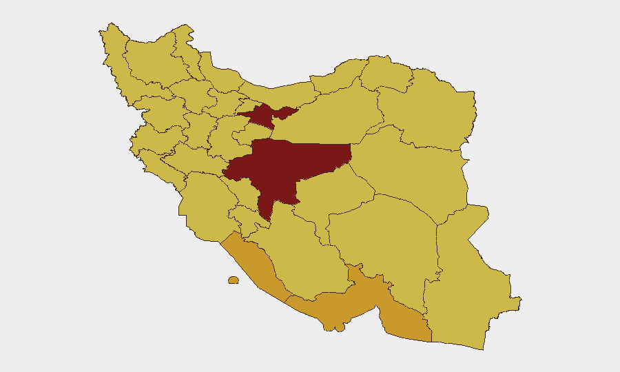
Tehran Province (risk 100) and Isfahan Province (93.6) drive Iran's composite threat score, reflecting concentration of political authority, security force density, protest activity, and state/media infrastructure in the capital and central regions. Bushehr, Hormozgan, and Ilam provinces (72–73 range) pose acute maritime and border risk due to proximity to the Strait of Hormuz, Persian Gulf shipping lanes, and Iraq border; drone and small-arms activity there directly threatens regional commerce and can trigger wider escalation. The remaining ranked provinces (70–71) remain elevated due to ongoing protest dynamics, security force presence, and Kurdish and Baloch minority areas with persistent sectarian or separatist tension. Maritime risk is geographically concentrated but operationally highest-consequence.
How GeoBit Would Assist
Security teams should deploy AOI Monitoring & Early Warning on Tehran, Isfahan, Hormozgan, and the Strait of Hormuz corridor to detect shifts in military activity, protest clustering, and maritime incidents in real time. Conflict & Military tracking—including force structure, drone capabilities, and naval positioning—combined with Maritime & Aviation tracking will provide early warning of Iranian military operations before they impact staff or assets. Intel Sweep across state media, Telegram, and X/Twitter, paired with Network & Actor Analysis, will clarify contradictions between official statements (e.g., Hormuz closure vs. openness) and identify which decision-makers control operational directives.
7-Day Outlook
Probability of further Iranian drone or naval activity against shipping in the Strait remains elevated (>60%) without immediate diplomatic breakthrough. Israeli military operations in southern Lebanon and US compliance with memorandum terms are the primary triggering variables; any new strike or perceived US default will likely provoke Iranian response within 48–72 hours. Commercial shipping delays, insurance premium spikes, and potential staff evacuation from southern provinces are foreseeable within one week if current trajectory persists.
Highest-Risk Areas — Ranked
| # | State / Region | Risk |
|---|---|---|
| 1 | Tehran Province | 100 |
| 2 | Isfahan Province | 93.6 |
| 3 | Bushehr Province | 72.6 |
| 4 | Hormozgan Province | 72.5 |
| 5 | Ilam Province | 70.9 |
| 6 | West Azerbaijan Province | 70.9 |
| 7 | East Azerbaijan Province | 70.7 |
| 8 | Chaharmahal and Bakhtiyari Province | 70.5 |
| 9 | Fars Province | 70.5 |
| 10 | South Khorasan Province | 70.5 |
| 11 | Sistan and Baluchestan Province | 70.4 |
| 12 | Razavi Khorasan | 70.2 |
Sources
Previous Daily Briefs
A new Iran brief is written every day — each with its own risk map and downloadable CSV. Here's the last week; use the calendar to go further back.
📅 Browse every day by calendar →
Highlighted days have a brief. Tap a day for that day's map & analysis, or “csv” for that day's dataset ($5).