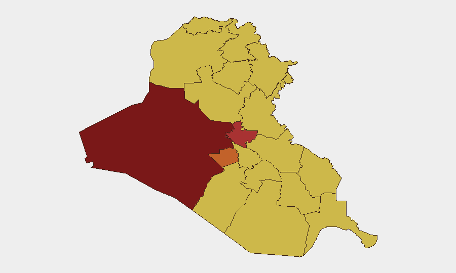
Situation Summary
Iraq remains at elevated composite threat level (#11 globally, risk score 100) with 523 tracked events. The security environment is driven by layered instability: localized militant and criminal activity in western and central governorates, periodic civil unrest over essential services, and recurring cross-border pressure from Iranian and U.S.-aligned actors. Near-term trajectory reflects chronic governance gaps and sectarian fault lines rather than imminent major escalation, though flashpoints remain volatile.
Key Developments
- Wasit Governorate (Kut) – 27 June 2026: Iraqi security forces conducted arrests during civil demonstrations over chronic power shortages. The incident reflects ongoing civil unrest tied to electricity supply failures and signals potential expansion of protest activity beyond Baghdad and major cities into secondary urban centers.
- Internal Iraqi Political Statements – 27 June 2026: Multiple public statements and rejections recorded between Iraqi state and non-state actors, alongside military demonstrations and political dissent signals. These suggest active internal friction over governance, military posture, or resource allocation, though specific trigger and actors require clarification from secondary sources.
- Iran–Iraq Cross-Border Signals – 27 June 2026: Threat statements attributed to Iran toward Iraqi targets reflect ongoing proxy and diplomatic tension. This aligns with historical patterns of Iranian leverage over Iraqi Shiite-aligned militias and political factions but does not indicate imminent kinetic escalation at this time.
- OPEC–Iraq Commercial/Political Dispute – 27 June 2026: Threat signal recorded between OPEC and Iraq, likely tied to oil production quotas or revenue disputes. Such friction can affect state resources available for security and public services, indirectly widening governance and civil unrest risks.
- International Diplomatic Friction – 25–27 June 2026: Public statements and disapproval from Western figures (David Petraeus) and Australian/other diplomatic actors signal renewed international scrutiny of Iraqi governance or military/security conduct. Does not directly indicate imminent threat to civilians or assets but reflects reputational and diplomatic stress.
Data Caveat: Open-source confirmation for additional specific incidents within the 24–48 hour window remains limited. Corroboration via mainstream news wires (Rudaw, Reuters, AFP Arabic) and real-time social OSINT is recommended before escalating operational decisions.
Highest-Risk Areas
Al-Anbar Governorate dominates the risk ranking (99.6), reflecting persistent militant presence, tribal instability, and proximity to Syrian border—a long-standing sanctuary and weapons-smuggling corridor. Baghdad (76.7) combines high population density, symbolic importance, and recurring sectarian and political violence. Karbala (75.3) and southern governorates (Basra, Maysan, Dhi Qar at 69.6–69.9) face compounded risks from civil unrest over services, criminal networks, and Iranian militia influence. Central governorates (Babil, Wasit, Qadisiyah) represent an emerging secondary-risk band, now visible in protest activity.
How GeoBit Would Assist
Security teams should deploy AOI Monitoring & Early Warning on high-risk governorates (Al-Anbar, Baghdad, Karbala) with alerting for protest activity, security force movements, and cross-border incursions. Intel Sweep and multi-language OSINT fusion (X/Twitter, Telegram, local news wires) will track political dissent, militia signaling, and civil unrest in near-real time. Routing & Network Analysis supports alternative journey planning and safe-passage assessment for personnel and supply convoys, particularly in Al-Anbar and central regions. Conflict & Military force-structure tracking will monitor Iraqi security forces, militia alignment, and Iranian/U.S. posture shifts.
7-Day Outlook
Expect continued civil unrest over electricity and services, particularly in secondary cities (Kut, Nasiriyah, Diwaniyah). No immediate spike in militant kinetic activity is indicated, though Al-Anbar remains prone to sudden incidents. Monitor Iranian and U.S. signaling for any escalatory shift; diplomatic friction and internal Iraqi political dispute suggest medium-term governance stress but not imminent destabilization.
Highest-Risk Areas — Ranked
| # | State / Region | Risk |
|---|---|---|
| 1 | Al-Anbar Governorate | 99.6 |
| 2 | Baghdad Governorate | 76.7 |
| 3 | Karbala | 75.3 |
| 4 | Al-Basra Governorate | 69.9 |
| 5 | Sulaymaniyah Governorate | 69.9 |
| 6 | Babil Governorate | 69.6 |
| 7 | Wasit Governorate | 69.6 |
| 8 | Al-Qadisiyah Governorate | 69.6 |
| 9 | Dhi Qar Governorate | 69.6 |
| 10 | Al-Muthanna Governorate | 69.6 |
| 11 | Maysan Governorate | 69.6 |
| 12 | Al-Najaf Governorate | 69.6 |
Sources
Previous Daily Briefs
A new Iraq brief is written every day — each with its own risk map and downloadable CSV. Here's the last week; use the calendar to go further back.
📅 Browse every day by calendar →
Highlighted days have a brief. Tap a day for that day's map & analysis, or “csv” for that day's dataset ($5).