Situation Summary
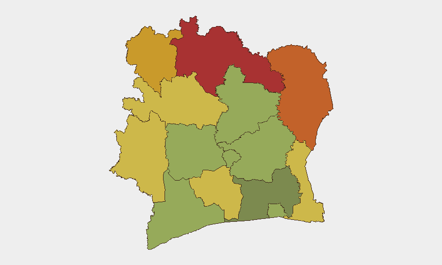
Ivory Coast remains at composite threat rank #67 globally, with a relatively calm security environment over the past 24–48 hours in terms of reported violent incidents, civil unrest, or infrastructure disruptions. The most significant activity has been an ongoing demolition and forced-relocation campaign in Abidjan's Attécoubé district targeting informal housing in flood- and landslide-risk zones, generating local humanitarian concerns but no large-scale violent response. Northern districts—particularly Savanes, Zanzan, and Denguélé—continue to carry substantially higher risk profiles, reflecting persistent exposure to trafficking, cross-border activity, and militia presence; however, no acute triggering events have been detected in the last 48 hours.
Key Developments
- Abidjan (Attécoubé district) – 20–22 July 2026 – Large-scale demolition and forced-eviction campaign continued in flood- and landslide-risk zones. Authorities destroyed informal housing on public land; residents reported inadequate notice and limited relocation alternatives, generating tension but no reported large-scale violent unrest.
- Abidjan (Marcory commune) – 21 July 2026 – Abidjan Tribunal handed down severe sentences against multiple defendants, including prominent local figures, in a high-profile criminal case. Judicial move reflects tougher stance on urban crime; no immediate retaliatory disturbances reported.
- Abidjan – 20 July 2026 – Anti-terrorism court released six opposition PDCI officials after months in custody. Release followed hearing regarding alleged state-security threats; no corroborated protests or political clashes linked to the decision in subsequent 24–48 hours.
- No acute security incidents (attacks, riots, major protests, or infrastructure disruptions) timestamped to 21–23 July 2026 have been corroborated in open-source reporting or social-media monitoring as of time of writing.
Highest-Risk Areas
The northern and northeastern districts—Savanes (risk 78), Zanzan (75), and Denguélé (72)—drive the country's overall threat profile, reflecting chronic exposure to organized crime, cross-border trafficking networks, and armed-group activity linked to the Mali–Burkina Faso border region. These areas remain persistently difficult to monitor and control; security presence is limited, and transient populations facilitate illicit movement. Comoé and Montagnes districts (70 and 68 respectively) carry elevated risk from similar dynamics. By contrast, Abidjan (45) and southern coastal districts rank lower despite urban crime and recent demolition-driven displacement; infrastructure and state capacity are comparatively stronger in these zones.
How GeoBit Would Assist
Security teams should deploy AOI Monitoring & Early Warning on Savanes, Zanzan, and Denguélé districts to detect emerging armed-group activity, trafficking flows, or militant-staging operations before acute incidents occur. Intel Sweep, multi-language OSINT, and X/Twitter & Telegram OSINT would capture local political sentiment, judicial developments, and displacement pressures (e.g., from the Attécoubé demolitions) that may signal downstream civil-unrest risk. For personnel or asset movements in-country, Routing & Network Analysis can identify safe transit corridors around high-risk northern zones, while GIS & Spatial Analysis combined with satellite imagery supports real-time site assessment in remote or contested areas.
7-Day Outlook
The current lull in acute incidents is unlikely to reflect fundamental improvement in underlying risk drivers; rather, it reflects normal variation in observable event frequency. The Attécoubé demolition operation may continue to generate localized tension and humanitarian issues, while northern border zones will remain subject to low-visibility trafficking and militia activity. No major triggering events (elections, high-profile arrests, or external shocks) are scheduled in the immediate 7-day window; security posture should remain steady but vigilant.
Highest-Risk Areas — Ranked
| # | State / Region | Risk |
|---|---|---|
| 1 | Savanes District | 78 |
| 2 | Zanzan District | 75 |
| 3 | Denguélé District | 72 |
| 4 | Comoé District | 70 |
| 5 | Montagnes District | 68 |
| 6 | Woroba District | 65 |
| 7 | Gôh-Djiboua District | 60 |
| 8 | Sassandra-Marahoué District | 58 |
| 9 | Vallée du Bandama District | 55 |
| 10 | Bas-Sassandra District | 52 |
| 11 | Lacs District | 48 |
| 12 | Abidjan | 45 |
Previous Daily Briefs
A new Ivory Coast brief is written every day — each with its own risk map and downloadable CSV. Here's the last week; use the calendar to go further back.
📅 Browse every day by calendar →
Highlighted days have a brief. Tap a day for that day's map & analysis, or “csv” for that day's dataset ($5).
Atlas — our AI intelligence desk — emails them this snapshot personally. Nothing else, no list.