Situation Summary
Lithuania remains a low-threat operating environment (global rank #140) with no significant security incidents recorded in the current reporting week. The country's proximity to Belarus and Russia creates persistent border-security exposure, most recently highlighted by an unmanned aerial vehicle incursion on September 14–15. NATO air-defense mechanisms remain active and responsive; overall trajectory is stable with manageable, localized risk concentrated in border and urban zones.
Key Developments
- Pratkūnai village, Kaišiadorys District — September 14–15 (response September 16): Italian NATO fighter jets operating under Baltic Air Policing mission shot down an unmanned drone that violated Lithuanian airspace. Lithuanian officials assessed the aircraft as likely Russian-made, originating from Belarus, and potentially carrying explosives intended for Ukraine. NATO's air-defense posture prevented further airspace penetration.
- Vilnius — September 16: Lithuania's Foreign Ministry summoned a Belarusian Embassy representative and lodged a formal diplomatic protest over the airspace violation. The ministry demanded explanation and commitment to preventive measures; incident underscores persistent cross-border air-traffic risk despite NATO presence.
Highest-Risk Areas
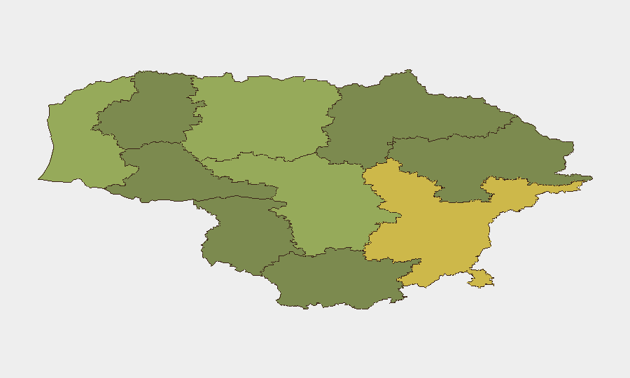
Vilnius County (risk 68) and Kaunas County (risk 58) drive the national composite threat score, reflecting urban-density exposure, administrative concentration, and proximity to transportation/commercial chokepoints. Klaipėda County (52) and Šiauliai County (42) carry elevated risk tied to border contiguity with Belarus and Russia; northern and eastern border zones show persistent vulnerability to incursion, reconnaissance, and transnational activity. Risk diminishes westward and southward (Telšiai, Marijampolė at 25–28), though no zone is categorized as secure. Diplomatic and NATO infrastructure concentration in Vilnius elevates stakes for any security incident in the capital.
How GeoBit Would Assist
Organizations with personnel or assets in Lithuania should deploy AOI Monitoring & Early Warning on border zones (Kaišiadorys, northern Šiauliai) to detect cross-border air or ground activity before NATO interception; Aviation Tracking to correlate civilian and military flight patterns with incident clusters; and Intel Sweep (X/Telegram OSINT, multi-language media) to identify emerging diplomatic tensions or technical warnings of repeat airspace violations. Conflict & Military capability would support real-time force-posture assessment of NATO rotation schedules and Lithuanian air-defense readiness. Network & Actor Analysis can map state and non-state actors conducting reconnaissance or hybrid operations in border regions.
7-Day Outlook
No imminent escalation is forecast. The September 14–15 drone incident is likely a routing error or reconnaissance probe from ongoing Ukraine-conflict activity; it does not signal an operational shift toward Lithuania. NATO's rapid response reinforces deterrence. Monitor diplomatic channels for Belarusian statements or further border violations; sustained quiet suggests the incident will remain isolated. Risk trajectory remains stable unless Russian or Belarusian military posture changes materially—an outcome not currently signaled in available intelligence.
Report prepared: 22 September 2026
Next update: 29 September 2026 (standard weekly cadence)
Highest-Risk Areas — Ranked
| # | State / Region | Risk |
|---|---|---|
| 1 | Vilnius County | 68 |
| 2 | Kaunas County | 58 |
| 3 | Klaipeda County | 52 |
| 4 | Siauliai County | 42 |
| 5 | Panevezys County | 38 |
| 6 | Taurage County | 35 |
| 7 | Utena County | 33 |
| 8 | Alytus County | 32 |
| 9 | Telsiai County | 28 |
| 10 | Marijampole County | 25 |
Sources
Previous Weekly Briefs
A new Lithuania brief is written every Monday, covering the week — each with its own risk map and downloadable CSV. Use the calendar to go further back.
- September 15, 2026
- September 8, 2026
- September 1, 2026
- August 30, 2026
- August 28, 2026
- August 25, 2026
- August 23, 2026
📅 Browse past briefs by calendar →
Highlighted days have a brief. Tap a day for that day's map & analysis, or “csv” for that day's dataset ($5).
Atlas — our AI intelligence desk — emails them this snapshot personally. Nothing else, no list.