Situation Summary
Mali remains Africa's 11th-highest-threat environment (composite score 100) with persistent jihadist activity, state-insurgent conventional clashes, and foreign military presence across the Sahel. No independently verified incident-level security events—attacks, armed clashes, major arrests, or infrastructure damage—were confirmed in the last 24–48 hours by credible open sources. Unconfirmed signals of aerial weapons activity near Bamako and military force engagements involving state and Moscow-linked actors on June 23 require field corroboration and do not yet establish ground truth. The operating environment remains volatile, particularly in Bamako and the northern/central regions.
Key Developments
- Russian Africa Corps force posture expansion (Kayes & Diéma, western Mali; June 22). Africa Intelligence reported a Russian Africa Corps re-equipment and security deployment plan at Kayes and Diéma military camps, including planned installation of a drone signal-jamming station, aimed at countering escalating jihadist threats. This represents an ongoing infrastructure and force-posture development rather than a discrete tactical incident.
- Unconfirmed aerial weapons activity near Bamako (June 23; requires verification). GeoBit event signals flagged aerial weapons activity involving Bamako and insurgent actors on June 23, but the signal lacks independent field or secondary-source corroboration and does not qualify as a verified incident at this time.
- No verified incident-level events in high-risk northern/central regions (past 48 hours). Despite traditionally elevated threat levels in Timbuktu, Ménaka, Gao, and Mopti, no independently confirmed attacks, clashes, or civil unrest events were reported in the last 24–48 hours by credible monitoring sources.
Highest-Risk Areas
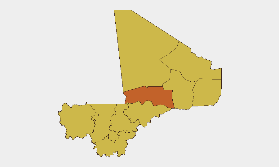
Bamako dominates the sub-national threat ranking (risk score 100), driven by its role as the capital, seat of government, and presence of foreign military advisors, diplomatic staff, and commercial activity—making it a priority target for both state security operations and insurgent activity. Northern and central Mali—Timbuktu (73.5), Ménaka, Gao, Kidal, Taoudénit, and Mopti (all 70)—remain persistently high-risk due to jihadist presence, weak state control, trafficking networks, and ongoing conventional military operations. Kayes (70, western Mali) has risen in tactical significance following announced Russian Africa Corps deployments. Southern regions including Koulikoro, Ségou, and Sikasso (70) face secondary but measurable risk from insurgent infiltration and criminal networks.
How GeoBit Would Assist
Security teams with personnel or assets in Mali should use AOI Monitoring & Early Warning on Bamako and the northern regions (Timbuktu, Gao, Ménaka) to receive real-time alerting on verified incident-level activity and avoid reliance on unconfirmed signals. OSINT fusion and corroboration across GeoBit's 100+ live feeds and multi-language search, combined with sentiment and temporal analysis, allows teams to distinguish verified incidents from unconfirmed event signals and assess information reliability. Conflict & Military battle mapping and force-structure tracking help corporate teams monitor Russian Africa Corps deployments, state military operations, and jihadist movements affecting route security and compound safety.
7-Day Outlook
No acute escalation has been confirmed since June 21, but the unverified signals of aerial and conventional military activity on June 23 suggest ongoing state-insurgent operations that may intensify. Russian Africa Corps re-equipment and positioning in western Mali is expected to continue, potentially shifting tactical focus and creating secondary displacement or recruitment pressures. Duty-of-care teams should maintain heightened monitoring of Bamako and northern zones and expect intermittent unconfirmed reports requiring rapid verification.
Highest-Risk Areas — Ranked
| # | State / Region | Risk |
|---|---|---|
| 1 | Bamako | 100 |
| 2 | Timbuktu | 73.5 |
| 3 | Ménaka | 70 |
| 4 | Kayes | 70 |
| 5 | Taoudénit Region | 70 |
| 6 | Kidal | 70 |
| 7 | Gao | 70 |
| 8 | Koulikoro | 70 |
| 9 | Ségou Region | 70 |
| 10 | Sikasso Region | 70 |
| 11 | Mopti | 70 |
Sources
Previous Daily Briefs
A new Mali brief is written every day — each with its own risk map and downloadable CSV. Here's the last week; use the calendar to go further back.
📅 Browse every day by calendar →
Highlighted days have a brief. Tap a day for that day's map & analysis, or “csv” for that day's dataset ($5).