Situation Summary
Mongolia remains a low-threat environment globally (rank #126) with no acute security incidents or armed conflict in the past 48 hours. However, a targeted protest raid on a Chinese-operated oil exploration camp in Dornod on 14 August has triggered heightened diplomatic attention and law-enforcement response, elevating sensitivity around foreign-invested extractive infrastructure. Concurrent administrative restrictions (traffic controls) and environmental hazards (elevated river levels, fuel supply strain) present secondary mobility and supply-chain risks rather than direct security threats.
Key Developments
- Kherlen Tohoi XXVIII oil camp, Dornod/Sukhbaatar aimags – protest raid follow-up (19 Aug 2026). On 14 August, Mongolian activists and residents entered the China-operated exploration camp, disrupted work, and damaged Chinese workers' property. By 19 August, Mongolian authorities had detained at least two protesters, opened an investigation, and publicly pledged stricter protection for foreign personnel and assets after China's chargé d'affaires formally raised security concerns on 18 August. Official messaging framed such interference as a threat to national economic security.
- Ulaanbaatar – odd–even licence-plate traffic restrictions in effect (19 Aug 2026). Central Ulaanbaatar (six districts) continues a rotating vehicle-access rule (15 Aug–12 Sep 2026), limiting circulation 07:00–21:00 daily. On 19 August, only odd-numbered plates were permitted during restricted hours. Affects commuting, crowding on public transit, and corporate shuttle/supply routing.
- River-basin flood warnings – lingering travel risk (valid as of 19 Aug 2026). Elevated water levels (5–20 cm above stage) persist in the Tuul, Sognogor, Baydrag, and Kharkhiraa basins, with ongoing advisory for camping, ford crossings, and rural access. Affects eastern and central travel corridors.
- National fuel supply crisis – medium-term disruption risk (reported 18 Aug 2026). Mongolia is importing emergency aviation kerosene and diesel from Belarus and Kazakhstan; domestic refineries' production timelines have shifted to 2028. No acute queuing or unrest incidents documented in the last 48 hours, but structural shortage creates background conditions for price volatility and public frustration.
- Diplomatic and security-posture shift (19 Aug 2026). Mongolia's government has signalled heightened enforcement around foreign-invested sites and heightened law-and-order messaging in response to the oil-camp incident, likely translating into stricter policing of environmental and labour protests at energy infrastructure.
Highest-Risk Areas
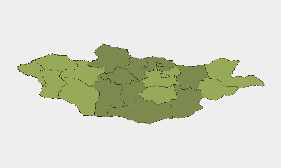
Dornod (risk 58) and Sukhbaatar (risk 55) dominate the sub-national ranking, driven primarily by the oil-camp protest and cross-border sensitivities with China; both aimags host extractive operations vulnerable to activist or local-grievance intrusions. Western border aimags (Uvs, Khovd, Bayan-Ölgii, risk 52–48) reflect persistent trafficking and informal border-crossing activity. Ulaanbaatar (risk 45), while lower-ranked than eastern peers, remains the administrative and diplomatic hub where enforcement actions and policy shifts generate downstream effects on corporate operations and foreign-personnel mobility.
How GeoBit Would Assist
Teams with people or assets in Mongolia should deploy AOI Monitoring & Early Warning on energy sites and supply corridors in Dornod/Sukhbaatar to detect protest mobilization or access-control breaches; parallel Intel Sweep and X/Twitter OSINT can track activist sentiment and local grievances around extractive projects. Routing & Network Analysis supports real-time journey planning around the Ulaanbaatar traffic restrictions and flood-affected river basins, while Economic & Trade monitoring flags fuel-supply trends and price volatility that may affect operations or workforce stability.
7-Day Outlook
Diplomatic tensions around the oil-camp incident will remain visible but are unlikely to escalate into widespread unrest; law enforcement will remain active at major energy sites. Traffic and environmental restrictions will persist (traffic rule through 12 September; flood warnings through early autumn). Fuel supply and price pressures will continue as a background operational friction rather than an acute crisis.
Highest-Risk Areas — Ranked
| # | State / Region | Risk |
|---|---|---|
| 1 | Dornod | 58 |
| 2 | Sükhbaatar | 55 |
| 3 | Uvs | 52 |
| 4 | Khovd | 50 |
| 5 | Bayan-Ölgii | 48 |
| 6 | Govi-Altai | 46 |
| 7 | Ulaanbaatar | 45 |
| 8 | Zavkhan | 44 |
| 9 | Töv | 42 |
| 10 | Dundgovi | 40 |
| 11 | Darkhan-Uul | 38 |
| 12 | Ömnögovi | 37 |
Sources
Previous Daily Briefs
A new Mongolia brief is written every day — each with its own risk map and downloadable CSV. Here's the last week; use the calendar to go further back.
- August 17, 2026
- August 15, 2026
- August 13, 2026
- August 11, 2026
- August 9, 2026
- August 8, 2026
- August 6, 2026
📅 Browse every day by calendar →
Highlighted days have a brief. Tap a day for that day's map & analysis, or “csv” for that day's dataset ($5).
Atlas — our AI intelligence desk — emails them this snapshot personally. Nothing else, no list.