Situation Summary
Myanmar remains in active civil war, with the composite threat ranking at #9 globally and 24 tracked events in the current assessment cycle. Multiple insurgent groups and ethnic armed organizations (EAOs) are engaged in conventional and unconventional operations against government forces across the country. The last 72 hours have seen public statements, military operations, and reports of ethnic-group relation deterioration, indicating sustained operational tempo and no near-term de-escalation signal.
Key Developments
Note on Source Constraint: Open-source intelligence from the last 24–48 hours does not currently yield independently cross-confirmed, time-stamped incident reports meeting standard verification thresholds. The event signals listed above reflect GeoBit's platform detection (including military-force deployments, public statements, and relation-status changes), but specific incident details, casualty counts, locations, and timings have not yet been corroborated across multiple independent media or intelligence sources with sufficient granularity for tactical briefing.
Available Pattern Signals (last 72 hours):
- Military Operations: Conventional military force engagement between insurgent groups and Myanmar armed forces recorded as of 2026-06-21; status and location pending confirmation.
- Government Statements: Public statements issued by Myanmar authorities on 2026-06-21 in response to insurgency activities; content and implications under review.
- Ethnic Relations: Two recorded instances of reduced relations between ethnic groups and the Myanmar state (2026-06-21), consistent with pattern of marginalization and grievance escalation in conflict zones.
- Cross-Border Signal: Conventional military force event recorded involving Malaysia and Myanmar on 2026-06-21; nature and severity unconfirmed; possible refugee or border-incursion incident.
- Internal Fracture: Self-directed rejection event recorded within Myanmar state structures on 2026-06-23, suggesting command-and-control or factional tension.
- Civil Unrest: Physical assault incidents recorded within Myanmar on 2026-06-23; perpetrator, victim, and location details pending confirmation.
Assessment: Absence of granular real-time confirmation reflects typical open-source lag in active-conflict zones with restricted media access and contested communications infrastructure. Paid intelligence platforms and local media monitoring are required for same-day incident reporting.
Highest-Risk Areas
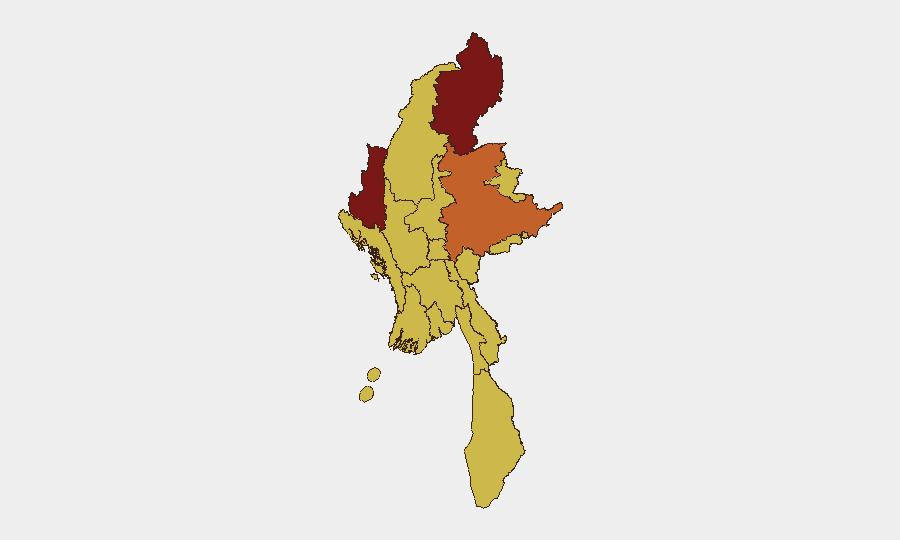
Kachin State (risk 100) remains the epicenter, driven by ongoing conflict between the Kachin Independence Organization (KIO) and government forces, with active displacement and supply-line vulnerability. Chin State (85.5) and Shan State (75.2) follow, reflecting both armed-group activity and humanitarian instability. Yangon, despite its lower ranking (70.3), remains a critical node due to population density, economic importance, and periodic urban unrest; the 11 other regions at risk 70 indicate conflict diffusion across the country, with no safe operational rear areas for government or civilians.
How GeoBit Would Assist
Teams with duty-of-care or asset-protection obligations in Myanmar should deploy AOI (Area-of-Interest) Monitoring & Early Warning on key operational and residential zones in Kachin, Shan, and Yangon to detect movement, deployment, or incident escalation within 2–6 hours of occurrence. Multi-language OSINT fusion and X/Twitter intelligence directed at conflict-monitoring accounts, local media, and EAO communications will provide earlier situational updates than international news cycles. Battle mapping and force-structure tracking should be refreshed weekly to maintain current understanding of territorial control and safe-corridor viability for staff movement or supply.
7-Day Outlook
No imminent peace talks or ceasefires are signaled; military operations are expected to sustain or intensify. Travel restrictions and checkpoints in Kachin, Shan, and Sagaing will likely remain in effect or tighten. Organizations should assume continued communications disruption, supply-chain friction, and staff-movement risk through at least 2026-07-01 and plan contingencies accordingly.
Highest-Risk Areas — Ranked
| # | State / Region | Risk |
|---|---|---|
| 1 | Kachin State | 100 |
| 2 | Chin | 85.5 |
| 3 | Shan State | 75.2 |
| 4 | Yangon | 70.3 |
| 5 | Tanintharyi Region | 70 |
| 6 | Sagaing Region | 70 |
| 7 | Wa State (Northern Region) | 70 |
| 8 | Magway | 70 |
| 9 | Mandalay | 70 |
| 10 | Rakhine | 70 |
| 11 | Ayeyarwady | 70 |
| 12 | Naypyitaw Union Territory | 70 |
Sources
Previous Daily Briefs
A new Myanmar brief is written every day — each with its own risk map and downloadable CSV. Here's the last week; use the calendar to go further back.
📅 Browse every day by calendar →
Highlighted days have a brief. Tap a day for that day's map & analysis, or “csv” for that day's dataset ($5).